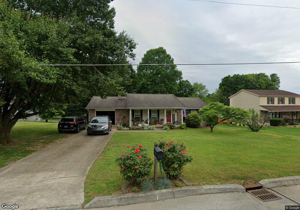
729 Montvue Ave Kingston, TN 37763
Estimated Value: $254,906 - $352,000
--
Bed
2
Baths
1,735
Sq Ft
$186/Sq Ft
Est. Value
About This Home
This home is located at 729 Montvue Ave, Kingston, TN 37763 and is currently estimated at $322,977, approximately $186 per square foot. 729 Montvue Ave is a home located in Roane County with nearby schools including Kingston Elementary School, Midtown Elementary School, and Midway Elementary School.
Ownership History
Date
Name
Owned For
Owner Type
Purchase Details
Closed on
Aug 8, 2001
Sold by
Timothy Theiss
Bought by
Harold Ochs
Current Estimated Value
Home Financials for this Owner
Home Financials are based on the most recent Mortgage that was taken out on this home.
Original Mortgage
$25,000
Interest Rate
7.19%
Purchase Details
Closed on
Apr 2, 1992
Bought by
Affadavit
Purchase Details
Closed on
Sep 4, 1987
Bought by
Theiss Timothy John and Ange La B
Purchase Details
Closed on
Sep 10, 1985
Bought by
Woody Elizabeth A
Create a Home Valuation Report for This Property
The Home Valuation Report is an in-depth analysis detailing your home's value as well as a comparison with similar homes in the area
Home Values in the Area
Average Home Value in this Area
Purchase History
| Date | Buyer | Sale Price | Title Company |
|---|---|---|---|
| Harold Ochs | $110,000 | -- | |
| Affadavit | -- | -- | |
| Theiss Timothy John | $55,000 | -- | |
| Woody Elizabeth A | -- | -- |
Source: Public Records
Mortgage History
| Date | Status | Borrower | Loan Amount |
|---|---|---|---|
| Closed | Woody Elizabeth A | $25,000 |
Source: Public Records
Tax History Compared to Growth
Tax History
| Year | Tax Paid | Tax Assessment Tax Assessment Total Assessment is a certain percentage of the fair market value that is determined by local assessors to be the total taxable value of land and additions on the property. | Land | Improvement |
|---|---|---|---|---|
| 2024 | -- | $36,750 | $5,875 | $30,875 |
| 2023 | $1,341 | $36,750 | $5,875 | $30,875 |
| 2022 | $1,341 | $36,750 | $5,875 | $30,875 |
| 2021 | $1,368 | $36,750 | $5,875 | $30,875 |
| 2020 | $1,366 | $36,750 | $5,875 | $30,875 |
| 2019 | $1,445 | $35,550 | $7,500 | $28,050 |
| 2018 | $1,409 | $35,550 | $7,500 | $28,050 |
| 2017 | $1,409 | $35,550 | $7,500 | $28,050 |
| 2016 | $1,409 | $35,550 | $7,500 | $28,050 |
| 2015 | $894 | $35,550 | $7,500 | $28,050 |
| 2013 | -- | $40,075 | $7,500 | $32,575 |
Source: Public Records
Map
Nearby Homes
- 121 Bailey Rd
- 708 Calvin St
- 709 Calvin St
- 722 Paint Rock Ferry Rd
- 732 Paint Rock Ferry Rd
- 947 Lawnville Rd
- 137 Scott Ln
- 208 Scott Ln
- 107 Hillcrest Ln
- 143 Shubert St
- 213 Willowbrook Dr
- 52 Paint Rock Ferry Rd
- 314 Woodlawn Dr
- 121 Highland Dr
- 907 Paint Rock Ferry Rd
- 303 Lynn St
- 108 Chestnut View Dr
- 155 Bowsprit Ln
- 610 E Race St
- 165 Newport Way
- 733 Montvue Ave
- 725 Montvue Ave
- 737 Montvue Ave
- 721 Montvue Ave
- 724 Montvue Ave
- 505 Calvin St
- 720 Montvue Ave
- 741 Montvue Ave
- 717 Montvue Ave
- 716 Montvue Ave
- 732 Montvue Ave
- 501 Calvin St
- 712 Montvue Ave
- 736 Montvue Ave
- 713 Montvue Ave
- 509 Calvin St
- 725 Eblen Cir
- 740 Montvue Ave
- 729 Eblen Cir
- 708 Montvue Ave