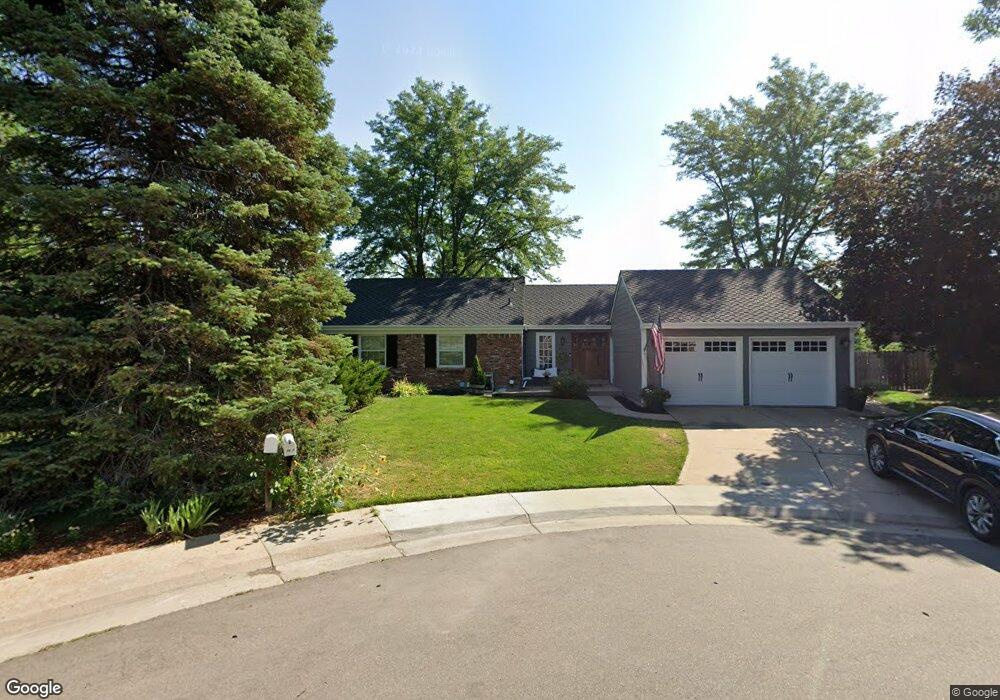
7291 E Davies Place Centennial, CO 80112
Homestead In The Willows NeighborhoodEstimated Value: $699,829 - $847,000
4
Beds
4
Baths
1,388
Sq Ft
$577/Sq Ft
Est. Value
About This Home
This home is located at 7291 E Davies Place, Centennial, CO 80112 and is currently estimated at $800,457, approximately $576 per square foot. 7291 E Davies Place is a home located in Arapahoe County with nearby schools including Homestead Elementary School, West Middle School, and Cherry Creek High School.
Ownership History
Date
Name
Owned For
Owner Type
Purchase Details
Closed on
Jul 17, 2006
Sold by
Thornquist Eugene and Thornquist Laura
Bought by
Maloney John
Current Estimated Value
Home Financials for this Owner
Home Financials are based on the most recent Mortgage that was taken out on this home.
Original Mortgage
$268,800
Outstanding Balance
$156,777
Interest Rate
6.62%
Mortgage Type
Purchase Money Mortgage
Estimated Equity
$643,680
Purchase Details
Closed on
Apr 4, 2000
Sold by
Associates Relocation Management Co Inc
Bought by
Thornquist Eugene and Thornquist Laura
Home Financials for this Owner
Home Financials are based on the most recent Mortgage that was taken out on this home.
Original Mortgage
$249,750
Interest Rate
8%
Purchase Details
Closed on
Jul 31, 1995
Sold by
Keslin Joseph A and Keslin Carmen M
Bought by
Belnap Craig S and Belnap Michelle L
Home Financials for this Owner
Home Financials are based on the most recent Mortgage that was taken out on this home.
Original Mortgage
$156,500
Interest Rate
6.25%
Purchase Details
Closed on
Aug 29, 1993
Sold by
Skinner Rebecca J Skinner Richard C
Bought by
Keslin Carmen M Keslin Joseph A
Home Financials for this Owner
Home Financials are based on the most recent Mortgage that was taken out on this home.
Original Mortgage
$88,800
Interest Rate
6.96%
Purchase Details
Closed on
Oct 14, 1987
Sold by
Conversion Arapco
Bought by
Skinner Rebecca J Skinner Richard C
Purchase Details
Closed on
Aug 1, 1977
Sold by
Conversion Arapco
Bought by
Conversion Arapco
Purchase Details
Closed on
Jul 4, 1776
Bought by
Conversion Arapco
Create a Home Valuation Report for This Property
The Home Valuation Report is an in-depth analysis detailing your home's value as well as a comparison with similar homes in the area
Home Values in the Area
Average Home Value in this Area
Purchase History
| Date | Buyer | Sale Price | Title Company |
|---|---|---|---|
| Maloney John | $336,000 | Utc Colorado | |
| Thornquist Eugene | $242,500 | -- | |
| Associates Relocation Management Co Inc | -- | -- | |
| Belnap Craig S | $178,500 | -- | |
| Keslin Carmen M Keslin Joseph A | -- | -- | |
| Keslin Joseph A | $178,800 | Land Title | |
| Skinner Rebecca J Skinner Richard C | -- | -- | |
| Conversion Arapco | -- | -- | |
| Conversion Arapco | -- | -- |
Source: Public Records
Mortgage History
| Date | Status | Borrower | Loan Amount |
|---|---|---|---|
| Open | Maloney John | $268,800 | |
| Previous Owner | Thornquist Eugene | $249,750 | |
| Previous Owner | Belnap Craig S | $156,500 | |
| Previous Owner | Keslin Joseph A | $88,800 |
Source: Public Records
Tax History
| Year | Tax Paid | Tax Assessment Tax Assessment Total Assessment is a certain percentage of the fair market value that is determined by local assessors to be the total taxable value of land and additions on the property. | Land | Improvement |
|---|---|---|---|---|
| 2025 | $5,102 | $50,375 | -- | -- |
| 2024 | $5,058 | $47,610 | -- | -- |
| 2023 | $5,058 | $47,610 | $0 | $0 |
| 2022 | $4,554 | $41,624 | $0 | $0 |
| 2021 | $4,215 | $41,624 | $0 | $0 |
| 2020 | $3,791 | $33,891 | $0 | $0 |
| 2019 | $3,269 | $33,891 | $0 | $0 |
| 2018 | $4,116 | $40,903 | $0 | $0 |
| 2017 | $4,069 | $40,903 | $0 | $0 |
| 2016 | $4,209 | $36,234 | $0 | $0 |
| 2015 | $4,059 | $36,234 | $0 | $0 |
| 2014 | $3,592 | $29,500 | $0 | $0 |
| 2013 | -- | $27,590 | $0 | $0 |
Source: Public Records
Map
Nearby Homes
- 7596 E Davies Ct
- 7105 E Briarwood Dr
- 7047 E Briarwood Dr Unit 166
- 7165 S Oneida Cir
- 7243 S Olive Way
- 7244 E Briarwood Cir Unit 2510
- 7178 E Bentley Cir Unit 196
- 7584 E Costilla Blvd
- 7513 E Costilla Blvd
- 6836 E Briarwood Dr Unit 22
- 7964 E Costilla Blvd
- 7007 E Hinsdale Ave
- 6809 S Niagara Ct
- 7405 E Fremont Dr
- 6622 S Olive Ct
- 6740 E Heritage Place S
- 7233 S Niagara Cir
- 6613 S Pontiac Ct
- 7359 S Syracuse Ct
- 6320 E Costilla Place
- 7271 E Davies Place
- 7266 E Davies Ave
- 7292 E Davies Place
- 7296 E Davies Ave
- 7272 E Davies Place
- 7251 E Davies Place
- 7246 E Davies Ave
- 7013 S Quince Cir
- 7262 E Davies Place
- 7009 S Quince Cir
- 7329 E Easter Ave
- 7216 E Davies Ave
- 7221 E Davies Place
- 7242 E Davies Place
- 7295 E Davies Ave
- 7143 S Poplar St
- 7132 S Poplar St
- 7142 S Poplar St
- 7017 S Quince Cir
- 7255 E Davies Ave
Your Personal Tour Guide
Ask me questions while you tour the home.