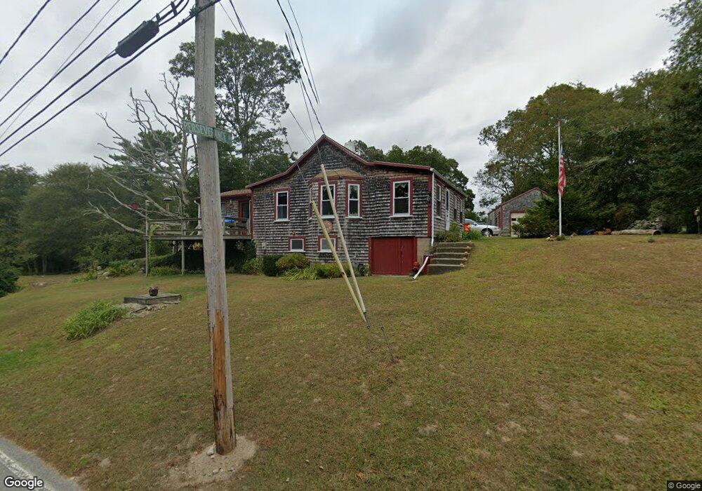
73 Cornell Rd Westport, MA 02790
Westport Point NeighborhoodEstimated Value: $400,000 - $804,000
2
Beds
--
Bath
1,188
Sq Ft
$494/Sq Ft
Est. Value
About This Home
This home is located at 73 Cornell Rd, Westport, MA 02790 and is currently estimated at $586,900, approximately $494 per square foot. 73 Cornell Rd is a home located in Bristol County with nearby schools including Alice A. Macomber Primary School, Westport Elementary School, and Westport Middle-High School.
Ownership History
Date
Name
Owned For
Owner Type
Purchase Details
Closed on
May 19, 1985
Bought by
Taylor John A and Taylor Toni Ann
Current Estimated Value
Create a Home Valuation Report for This Property
The Home Valuation Report is an in-depth analysis detailing your home's value as well as a comparison with similar homes in the area
Home Values in the Area
Average Home Value in this Area
Purchase History
| Date | Buyer | Sale Price | Title Company |
|---|---|---|---|
| Taylor John A | $50,000 | -- |
Source: Public Records
Mortgage History
| Date | Status | Borrower | Loan Amount |
|---|---|---|---|
| Open | Taylor John A | $70,000 | |
| Closed | Taylor John A | $50,000 | |
| Closed | Taylor John A | $46,000 | |
| Closed | Taylor John A | $25,000 |
Source: Public Records
Tax History Compared to Growth
Tax History
| Year | Tax Paid | Tax Assessment Tax Assessment Total Assessment is a certain percentage of the fair market value that is determined by local assessors to be the total taxable value of land and additions on the property. | Land | Improvement |
|---|---|---|---|---|
| 2025 | $3,631 | $487,400 | $317,000 | $170,400 |
| 2024 | $3,465 | $448,200 | $279,400 | $168,800 |
| 2023 | $2,964 | $363,200 | $210,300 | $152,900 |
| 2022 | $2,894 | $341,300 | $210,300 | $131,000 |
| 2021 | $2,787 | $323,300 | $191,500 | $131,800 |
| 2020 | $2,629 | $311,900 | $184,000 | $127,900 |
| 2019 | $2,528 | $305,700 | $177,900 | $127,800 |
| 2018 | $2,266 | $277,300 | $181,500 | $95,800 |
| 2017 | $2,192 | $275,000 | $181,500 | $93,500 |
| 2016 | $2,175 | $275,000 | $181,500 | $93,500 |
| 2015 | $2,074 | $261,600 | $181,500 | $80,100 |
Source: Public Records
Map
Nearby Homes
- 1346 Main Rd Unit B
- 1580 Main Rd
- 1749 Main Rd
- 17 Quail Trail
- 101 Adamsville Rd
- 225 Hixbridge Rd
- 920 Drift Rd
- 1702J Drift Rd
- 1881 Main Rd
- 837 Main Rd
- 1702 Drift Rd
- 245 John Dyer Rd
- 19 Seabury Ln
- 99 Sylvia Ln
- 8 Village Way
- 7 Village Way
- 15 Village Way
- 255 John Dyer Rd
- 116 Amy Hart Path
- 184 Field Stone Ln
- 67 Cornell Rd
- 70 Cornell Rd
- 4 Perseverance Ln
- 62 Cornell Rd
- 10 Perseverance Ln
- 95 Cornell Rd
- 65 Cornell Rd
- 55 Cornell Rd
- 63 Cornell Rd
- 49 Cornell Rd
- 43 Cornell Rd
- 105 Cornell Rd
- 18 Perseverance Ln
- 115 Cornell Rd
- 35 Cornell Rd
- 33 Cornell Rd
- 24 Perseverance Ln
- 121 Cornell Rd
- 29 Cornell Rd
- 33 Perseverance Ln