Estimated Value: $197,000 - $257,000
3
Beds
2
Baths
1,296
Sq Ft
$174/Sq Ft
Est. Value
About This Home
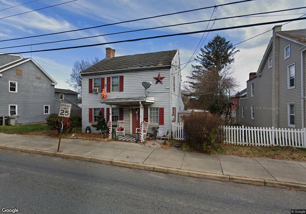
This home is located at 73 N Main St, Dover, PA 17315 and is currently estimated at $226,147, approximately $174 per square foot. 73 N Main St is a home located in York County with nearby schools including Dover Area High School and Lighthouse Christian School.
Ownership History
Date
Name
Owned For
Owner Type
Purchase Details
Closed on
May 20, 2009
Sold by
Funke William P and Wallace Autumn M
Bought by
Hernley Dennis and Hernley Angela
Current Estimated Value
Home Financials for this Owner
Home Financials are based on the most recent Mortgage that was taken out on this home.
Original Mortgage
$80,000
Interest Rate
4.87%
Mortgage Type
Purchase Money Mortgage
Purchase Details
Closed on
May 9, 2006
Sold by
Wolf Patricia A and Wolf Timothy A
Bought by
Funke William P
Home Financials for this Owner
Home Financials are based on the most recent Mortgage that was taken out on this home.
Original Mortgage
$76,665
Interest Rate
9.25%
Mortgage Type
Purchase Money Mortgage
Create a Home Valuation Report for This Property
The Home Valuation Report is an in-depth analysis detailing your home's value as well as a comparison with similar homes in the area
Home Values in the Area
Average Home Value in this Area
Purchase History
| Date | Buyer | Sale Price | Title Company |
|---|---|---|---|
| Hernley Dennis | $82,000 | None Available | |
| Funke William P | $80,700 | None Available |
Source: Public Records
Mortgage History
| Date | Status | Borrower | Loan Amount |
|---|---|---|---|
| Closed | Hernley Dennis | $80,000 | |
| Previous Owner | Funke William P | $76,665 |
Source: Public Records
Tax History Compared to Growth
Tax History
| Year | Tax Paid | Tax Assessment Tax Assessment Total Assessment is a certain percentage of the fair market value that is determined by local assessors to be the total taxable value of land and additions on the property. | Land | Improvement |
|---|---|---|---|---|
| 2025 | $3,128 | $88,990 | $27,120 | $61,870 |
| 2024 | $3,128 | $88,990 | $27,120 | $61,870 |
| 2023 | $3,128 | $88,990 | $27,120 | $61,870 |
| 2022 | $3,075 | $88,990 | $27,120 | $61,870 |
| 2021 | $2,915 | $88,990 | $27,120 | $61,870 |
| 2020 | $2,891 | $88,990 | $27,120 | $61,870 |
| 2019 | $2,835 | $88,990 | $27,120 | $61,870 |
| 2018 | $2,796 | $88,990 | $27,120 | $61,870 |
| 2017 | $2,796 | $88,990 | $27,120 | $61,870 |
| 2016 | $0 | $88,990 | $27,120 | $61,870 |
| 2015 | -- | $88,990 | $27,120 | $61,870 |
| 2014 | -- | $88,990 | $27,120 | $61,870 |
Source: Public Records
Map
Nearby Homes
- 33 S Main St
- 0 W Canal Rd
- 4013 Somerset Rd
- 1841 Wyatt Cir
- 2063 Wyatt Cir
- 4008 Country Dr
- 3975 Craig Ave
- 3960 Sheppard Dr
- 2856 W Canal Rd
- 2041 Shaffer Cir
- 86 Cherokee Ave
- 2689 Victorian Dr
- 2697 Victorian Dr
- 2653 Victorian Dr
- 2637 Victorian Dr
- 2645 Victorian Dr
- 2641 Victorian Dr
- 2673 Victorian Dr
- 2685 Victorian Dr
- 2670 Victorian Dr