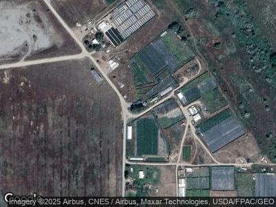
73 Pit Rd Unit 2 parcels Brewster, WA 98812
Estimated Value: $247,000 - $304,000
2
Beds
1
Bath
820
Sq Ft
$337/Sq Ft
Est. Value
About This Home
This home is located at 73 Pit Rd Unit 2 parcels, Brewster, WA 98812 and is currently estimated at $276,683, approximately $337 per square foot. 73 Pit Rd Unit 2 parcels is a home located in Okanogan County with nearby schools including Brewster Elementary School and Brewster High School.
Ownership History
Date
Name
Owned For
Owner Type
Purchase Details
Closed on
Sep 4, 2018
Sold by
Taylor Timothy A
Bought by
Taylor Terry
Current Estimated Value
Purchase Details
Closed on
Mar 10, 2010
Sold by
Jenkins Ruth S
Bought by
Barack Robert J and Barack Priscilla M
Purchase Details
Closed on
Apr 27, 2007
Sold by
Taylor David S and Taylor Nancy M
Bought by
Jenkins Ruth S
Purchase Details
Closed on
Jul 26, 2006
Sold by
Turner Kendall D and Turner Vicki A
Bought by
Taylor David S and Taylor Nancy M
Home Financials for this Owner
Home Financials are based on the most recent Mortgage that was taken out on this home.
Original Mortgage
$90,000
Interest Rate
6.76%
Mortgage Type
Purchase Money Mortgage
Purchase Details
Closed on
Nov 22, 2005
Sold by
Dammann Nancy Lillie
Bought by
Turner Kendall
Create a Home Valuation Report for This Property
The Home Valuation Report is an in-depth analysis detailing your home's value as well as a comparison with similar homes in the area
Home Values in the Area
Average Home Value in this Area
Purchase History
| Date | Buyer | Sale Price | Title Company |
|---|---|---|---|
| Taylor Terry | -- | None Available | |
| Barack Robert J | -- | None Available | |
| Jenkins Ruth S | $2,500 | None Available | |
| Taylor David S | $140,000 | Baines Title Co | |
| Turner Kendall | $55,000 | None Available |
Source: Public Records
Mortgage History
| Date | Status | Borrower | Loan Amount |
|---|---|---|---|
| Previous Owner | Taylor David S | $90,000 |
Source: Public Records
Tax History Compared to Growth
Tax History
| Year | Tax Paid | Tax Assessment Tax Assessment Total Assessment is a certain percentage of the fair market value that is determined by local assessors to be the total taxable value of land and additions on the property. | Land | Improvement |
|---|---|---|---|---|
| 2025 | $1,955 | $203,200 | $56,200 | $147,000 |
| 2024 | $1,955 | $184,000 | $56,200 | $127,800 |
| 2022 | $1,538 | $113,900 | $20,200 | $93,700 |
| 2021 | $1,318 | $113,900 | $20,200 | $93,700 |
| 2020 | $1,246 | $98,300 | $20,200 | $78,100 |
| 2019 | $1,206 | $98,300 | $20,200 | $78,100 |
| 2018 | $1,351 | $98,300 | $20,200 | $78,100 |
| 2017 | $1,324 | $102,900 | $27,800 | $75,100 |
| 2016 | $1,059 | $102,900 | $27,800 | $75,100 |
| 2015 | $1,092 | $102,900 | $27,800 | $75,100 |
| 2013 | -- | $102,900 | $27,800 | $75,100 |
Source: Public Records
Map
Nearby Homes
- 626 Monse River Rd
- 624 Monse River Rd
- 616 Monse River Rd
- 608 Monse River Rd
- 27061 U S 97
- 26 Hadley Rd
- 24 Hadley Rd
- 0 Plata Rd Unit NWM2328415
- 417 Plata Rd
- 0 Lot 2 Tennessee Walker
- 614 Monse River Rd
- 0 Lot 1 Lipizzan
- 175 Plata Rd
- 0 Lipizzan Lot 3 Unit NWM2362719
- 0 lot 3 Trigger Dr
- 13 Little Spur Ln
- 306 Monse River Rd
- 0 Soap Lake Rd Unit NWM2067871
- 284 Monse Bridge Rd
- 490 Valley Rd
- 73 Pit Rd
- 73 Pit Rd Unit 2 parcels
- 75 Pit Rd
- 91 Pit Rd
- 53 Pit Rd
- 74 Pit Rd
- 45 Pit Rd
- 54 Pit Rd
- 628 Monse River Rd
- 39 Pit Rd
- 0 Pit Rd
- 27129 U S 97
- 630 Monse River Rd
- 1 Monse River Rd
- 2 Monse River Rd
- 0 Tbd Monse River Rd Unit 1505734
- 0 Tbd Monse River Rd Unit 1505732
- 0 Tbd Monse River Rd Unit 1505712
- 0 Tbd Monse River Rd Unit 1505704
- 23 Pit Rd
