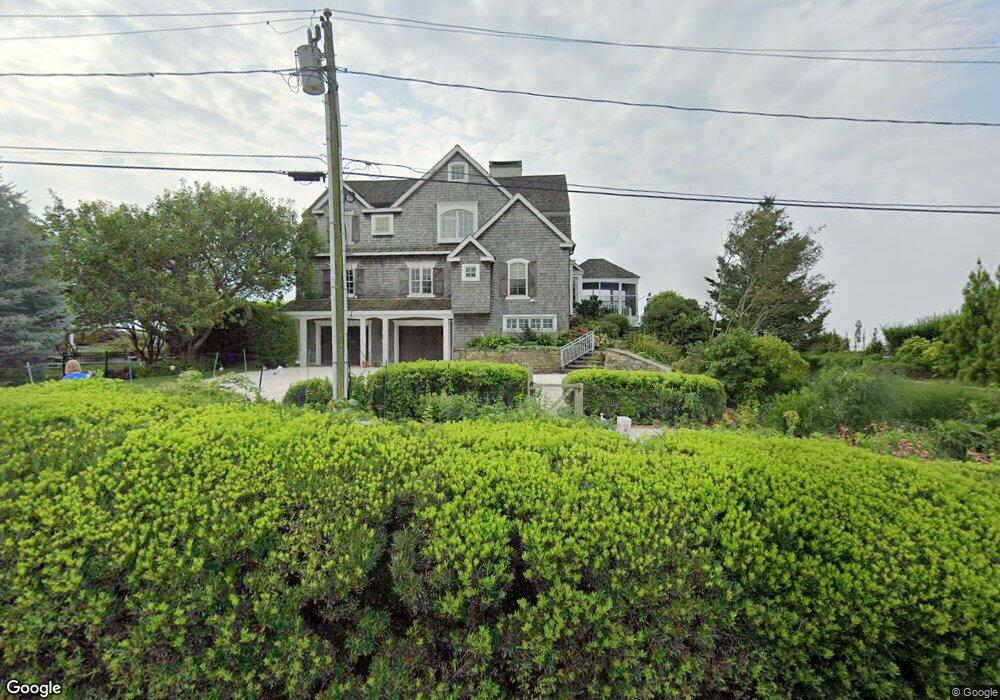
73 Stone Rd Madison, CT 06443
Estimated Value: $2,434,000 - $4,367,000
3
Beds
4
Baths
3,623
Sq Ft
$908/Sq Ft
Est. Value
About This Home
This home is located at 73 Stone Rd, Madison, CT 06443 and is currently estimated at $3,291,048, approximately $908 per square foot. 73 Stone Rd is a home located in New Haven County with nearby schools including Walter C. Polson Upper Middle School, Daniel Hand High School, and Our Lady of Mercy Preparatory Academy.
Ownership History
Date
Name
Owned For
Owner Type
Purchase Details
Closed on
May 28, 2014
Sold by
Bradly John F and Isleib Roberta A
Bought by
Roberta A Isleib Lt and Brady John F
Current Estimated Value
Purchase Details
Closed on
Sep 15, 1997
Sold by
Lucas Ian L and Brayton Jane G
Bought by
Brady John F and Isleib Roberta A
Home Financials for this Owner
Home Financials are based on the most recent Mortgage that was taken out on this home.
Original Mortgage
$675,000
Interest Rate
7.25%
Mortgage Type
Unknown
Purchase Details
Closed on
Apr 24, 1996
Sold by
Orvis Kenneth G
Bought by
Gordon Kenneth and Brayton Jane G
Create a Home Valuation Report for This Property
The Home Valuation Report is an in-depth analysis detailing your home's value as well as a comparison with similar homes in the area
Home Values in the Area
Average Home Value in this Area
Purchase History
| Date | Buyer | Sale Price | Title Company |
|---|---|---|---|
| Roberta A Isleib Lt | -- | -- | |
| John F Brady Lt | -- | -- | |
| Brady John F | $500,000 | -- | |
| Gordon Kenneth | $60,000 | -- |
Source: Public Records
Mortgage History
| Date | Status | Borrower | Loan Amount |
|---|---|---|---|
| Previous Owner | Gordon Kenneth | $623,000 | |
| Previous Owner | Gordon Kenneth | $675,000 |
Source: Public Records
Tax History
| Year | Tax Paid | Tax Assessment Tax Assessment Total Assessment is a certain percentage of the fair market value that is determined by local assessors to be the total taxable value of land and additions on the property. | Land | Improvement |
|---|---|---|---|---|
| 2025 | $44,723 | $1,993,900 | $1,357,200 | $636,700 |
| 2024 | $43,866 | $1,993,900 | $1,357,200 | $636,700 |
| 2023 | $48,473 | $1,617,400 | $1,252,100 | $365,300 |
| 2022 | $47,568 | $1,617,400 | $1,252,100 | $365,300 |
| 2021 | $7,918 | $1,617,400 | $1,252,100 | $365,300 |
| 2020 | $2,520 | $1,617,400 | $1,252,100 | $365,300 |
| 2019 | $2,298 | $1,617,400 | $1,252,100 | $365,300 |
| 2018 | $47,477 | $1,693,200 | $1,322,800 | $370,400 |
| 2017 | $46,224 | $1,693,200 | $1,322,800 | $370,400 |
| 2016 | $44,853 | $1,693,200 | $1,322,800 | $370,400 |
| 2015 | $43,617 | $1,693,200 | $1,322,800 | $370,400 |
| 2014 | $45,809 | $1,820,000 | $1,359,600 | $460,400 |
Source: Public Records
Map
Nearby Homes
- 61 Hartford Ave
- 24 Ridgewood Ave
- 46A Beach Ave
- 115 Harbor Ave
- 41 Harbor Ave
- 58 Neck Rd
- 42 Neck Rd
- 4 Boston Post Rd
- 505 Old Whitfield St
- 19 Green Acres Dr
- 80 Seaview Terrace Unit 31
- 80 Seaview Terrace Unit 3
- 31 Stony Lane Lot 3 Rd
- 82 Raymond Rd
- 31 Stony Lane Lot 2 Rd
- 31 Stony Lane Lot 1 Rd
- 6 Rollwood Dr
- 9 Sparrow Bush Ln
- 405 Whitfield St Unit 2
- 395 Boston Post Rd
Your Personal Tour Guide
Ask me questions while you tour the home.