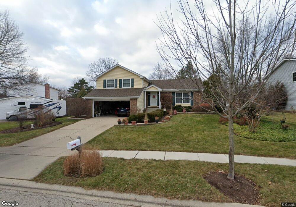
730 Butterfield Dr Algonquin, IL 60102
High Hill Farms NeighborhoodEstimated Value: $335,055 - $403,000
--
Bed
1
Bath
1,420
Sq Ft
$269/Sq Ft
Est. Value
About This Home
This home is located at 730 Butterfield Dr, Algonquin, IL 60102 and is currently estimated at $381,764, approximately $268 per square foot. 730 Butterfield Dr is a home located in McHenry County with nearby schools including Westfield Community School, Kenneth E Neubert Elementary School, and United Junior High School.
Ownership History
Date
Name
Owned For
Owner Type
Purchase Details
Closed on
Dec 16, 2009
Sold by
Glogowski Jerrold S and Glogowski Elizabeth L
Bought by
Glogowski Jerrold S and Glogowski Elizabeth L
Current Estimated Value
Home Financials for this Owner
Home Financials are based on the most recent Mortgage that was taken out on this home.
Original Mortgage
$118,271
Interest Rate
4.84%
Mortgage Type
New Conventional
Purchase Details
Closed on
May 22, 1997
Sold by
Scheurer Steven W and Scheurer Rita E
Bought by
Glogowski Jerrold S and Drover Elizabeth L
Home Financials for this Owner
Home Financials are based on the most recent Mortgage that was taken out on this home.
Original Mortgage
$116,800
Interest Rate
8%
Create a Home Valuation Report for This Property
The Home Valuation Report is an in-depth analysis detailing your home's value as well as a comparison with similar homes in the area
Home Values in the Area
Average Home Value in this Area
Purchase History
| Date | Buyer | Sale Price | Title Company |
|---|---|---|---|
| Glogowski Jerrold S | -- | Mortgage Information Service | |
| Glogowski Jerrold S | $146,000 | Attorneys Natl Title Network |
Source: Public Records
Mortgage History
| Date | Status | Borrower | Loan Amount |
|---|---|---|---|
| Closed | Glogowski Jerrold S | $118,271 | |
| Closed | Glogowski Jerrold S | $116,800 |
Source: Public Records
Tax History Compared to Growth
Tax History
| Year | Tax Paid | Tax Assessment Tax Assessment Total Assessment is a certain percentage of the fair market value that is determined by local assessors to be the total taxable value of land and additions on the property. | Land | Improvement |
|---|---|---|---|---|
| 2024 | $7,514 | $104,052 | $22,359 | $81,693 |
| 2023 | $7,121 | $93,061 | $19,997 | $73,064 |
| 2022 | $5,998 | $75,937 | $21,044 | $54,893 |
| 2021 | $5,745 | $70,744 | $19,605 | $51,139 |
| 2020 | $5,589 | $68,240 | $18,911 | $49,329 |
| 2019 | $5,446 | $65,314 | $18,100 | $47,214 |
| 2018 | $5,179 | $60,337 | $16,721 | $43,616 |
| 2017 | $5,063 | $56,841 | $15,752 | $41,089 |
| 2016 | $4,975 | $53,312 | $14,774 | $38,538 |
| 2013 | -- | $54,892 | $13,783 | $41,109 |
Source: Public Records
Map
Nearby Homes
- 721 Brentwood Ct
- 1235 Fairmont Ct
- 615 Harper Dr
- 266 Grandview Ct
- 16 Brian Ct
- 909 Roger St
- 1431 Essex St
- 102 Center St
- 1426 Grandview Ct Unit 1
- 700 Fairfield Ln
- 809 Menominee Dr
- 807 Menominee Dr
- 1 N Hubbard St
- SWC Talaga and Algonquin Rd
- LOT 3 Blackhawk Dr
- 937 Mesa Dr
- 900 Windstone Ct
- 921 Cynthia Ln
- 0 River Dr N Unit MRD12473279
- 135 Arquilla Dr
- 720 Butterfield Dr
- 740 Butterfield Dr
- 711 Brentwood Ct
- 710 Butterfield Dr
- 731 Butterfield Dr
- 741 Butterfield Dr
- 721 Butterfield Dr
- 701 Brentwood Ct
- 751 Butterfield Dr
- 700 Butterfield Dr
- 711 Butterfield Dr
- 811 Butterfield Dr
- 821 Butterfield Dr
- 831 Butterfield Dr
- 801 Butterfield Dr
- 761 Butterfield Dr
- 700 Brentwood Ct
- 730 Chestnut Ct
- 720 Chestnut Ct
- 701 Butterfield Dr