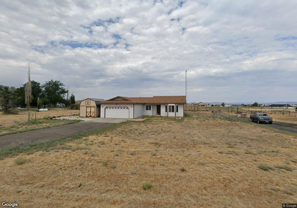
731 Devon Dr Spring Creek, NV 89815
Estimated Value: $350,000 - $363,000
3
Beds
2
Baths
1,430
Sq Ft
$248/Sq Ft
Est. Value
About This Home
This home is located at 731 Devon Dr, Spring Creek, NV 89815 and is currently estimated at $354,507, approximately $247 per square foot. 731 Devon Dr is a home located in Elko County with nearby schools including Spring Creek Elementary School, Spring Creek Middle School, and Spring Creek High School.
Ownership History
Date
Name
Owned For
Owner Type
Purchase Details
Closed on
May 2, 2018
Sold by
Schooley Daniel
Bought by
Ahrens Tyler M and Ahrens Krista A
Current Estimated Value
Home Financials for this Owner
Home Financials are based on the most recent Mortgage that was taken out on this home.
Original Mortgage
$198,850
Outstanding Balance
$171,413
Interest Rate
4.45%
Mortgage Type
New Conventional
Estimated Equity
$183,094
Purchase Details
Closed on
Nov 26, 2007
Sold by
Ruth Charlie G and Ruth Wilma F
Bought by
Schooley Daniel
Home Financials for this Owner
Home Financials are based on the most recent Mortgage that was taken out on this home.
Original Mortgage
$200,000
Interest Rate
6.3%
Mortgage Type
Purchase Money Mortgage
Purchase Details
Closed on
Jun 13, 2005
Sold by
Ruth Charlie G
Bought by
Ruth Charlie G and Ruth Wilma F
Create a Home Valuation Report for This Property
The Home Valuation Report is an in-depth analysis detailing your home's value as well as a comparison with similar homes in the area
Purchase History
| Date | Buyer | Sale Price | Title Company |
|---|---|---|---|
| Ahrens Tyler M | $205,000 | Stewart Title Elko | |
| Schooley Daniel | $225,000 | Stewart Title | |
| Ruth Charlie G | $95,915 | None Available |
Source: Public Records
Mortgage History
| Date | Status | Borrower | Loan Amount |
|---|---|---|---|
| Open | Ahrens Tyler M | $198,850 | |
| Previous Owner | Schooley Daniel | $200,000 |
Source: Public Records
Tax History
| Year | Tax Paid | Tax Assessment Tax Assessment Total Assessment is a certain percentage of the fair market value that is determined by local assessors to be the total taxable value of land and additions on the property. | Land | Improvement |
|---|---|---|---|---|
| 2025 | $1,792 | $77,508 | $21,000 | $56,508 |
| 2024 | $1,792 | $78,953 | $21,000 | $57,953 |
| 2023 | $1,587 | $65,489 | $11,200 | $54,289 |
| 2022 | $1,534 | $57,226 | $11,200 | $46,026 |
| 2021 | $1,570 | $56,109 | $11,200 | $44,909 |
| 2020 | $1,533 | $56,801 | $11,200 | $45,601 |
| 2019 | $1,479 | $52,352 | $8,750 | $43,602 |
| 2018 | $1,483 | $52,675 | $8,750 | $43,925 |
| 2017 | $1,369 | $53,327 | $8,750 | $44,577 |
| 2016 | $1,380 | $52,326 | $8,750 | $43,576 |
| 2015 | $1,340 | $51,834 | $8,750 | $43,084 |
| 2014 | $1,302 | $49,925 | $8,750 | $41,175 |
Source: Public Records
Map
Nearby Homes
- 787 Clover Dr
- 709 Parkridge Pkwy
- 611 Westcott Dr
- 686 Westcott Dr
- 751 Bronco Dr
- 768 Alpine Dr
- 728 Parkridge Pkwy
- 726 Bronco Dr
- 647 Abarr Dr
- 584 Thistle Dr
- 565 Abarr Dr
- 663 Willington Dr
- 629 Palace Pkwy
- 936 Buckskin Place
- 539 Palace Pkwy
- 515 Foxridge Dr
- 598 Palace Pkwy
- 891 Eastlake Dr
- 899 Eastlake Dr
- 472 Foxridge Dr
Your Personal Tour Guide
Ask me questions while you tour the home.