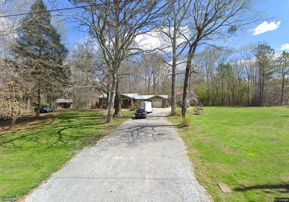
731 Jones Rd La Fayette, GA 30728
Noble NeighborhoodEstimated Value: $215,769 - $228,000
2
Beds
2
Baths
1,248
Sq Ft
$178/Sq Ft
Est. Value
About This Home
This home is located at 731 Jones Rd, La Fayette, GA 30728 and is currently estimated at $221,942, approximately $177 per square foot. 731 Jones Rd is a home located in Walker County with nearby schools including Rock Spring Elementary School, Lafayette High School, and Alice M Daley Adventist School.
Ownership History
Date
Name
Owned For
Owner Type
Purchase Details
Closed on
Oct 19, 2006
Sold by
Not Provided
Bought by
Blaylock Charles T and Blaylock Lisa L
Current Estimated Value
Purchase Details
Closed on
May 2, 2006
Sold by
Not Provided
Bought by
Blaylock Charles T and Blaylock Lisa L
Purchase Details
Closed on
Oct 8, 1998
Sold by
Edwards Charles
Bought by
Morgan Roy
Purchase Details
Closed on
Mar 1, 1988
Bought by
Edwards Charles
Create a Home Valuation Report for This Property
The Home Valuation Report is an in-depth analysis detailing your home's value as well as a comparison with similar homes in the area
Home Values in the Area
Average Home Value in this Area
Purchase History
| Date | Buyer | Sale Price | Title Company |
|---|---|---|---|
| Blaylock Charles T | -- | -- | |
| Blaylock Charles T | -- | -- | |
| Blaylock Charles T | -- | -- | |
| Morgan Roy | $68,000 | -- | |
| Edwards Charles | -- | -- |
Source: Public Records
Tax History Compared to Growth
Tax History
| Year | Tax Paid | Tax Assessment Tax Assessment Total Assessment is a certain percentage of the fair market value that is determined by local assessors to be the total taxable value of land and additions on the property. | Land | Improvement |
|---|---|---|---|---|
| 2024 | $1,703 | $77,238 | $6,606 | $70,632 |
| 2023 | $1,631 | $72,289 | $5,242 | $67,047 |
| 2022 | $1,514 | $61,767 | $3,784 | $57,983 |
| 2021 | $1,204 | $43,972 | $3,784 | $40,188 |
| 2020 | $1,036 | $36,146 | $3,784 | $32,362 |
| 2019 | $1,054 | $36,146 | $3,784 | $32,362 |
| 2018 | $956 | $36,146 | $3,784 | $32,362 |
| 2017 | $1,155 | $36,146 | $3,784 | $32,362 |
| 2016 | $966 | $36,146 | $3,784 | $32,362 |
| 2015 | $827 | $28,773 | $5,544 | $23,229 |
| 2014 | $740 | $28,773 | $5,544 | $23,229 |
| 2013 | -- | $28,773 | $5,544 | $23,229 |
Source: Public Records
Map
Nearby Homes
- 10180 Us Highway 27
- 0 Veeler Rd Unit 1522679
- 0 Veeler Rd Unit 10628696
- 23 Willow Cir
- 16 Willow Cir
- 11 Willow Cir
- The Pearson Plan at Laurel Ridge
- The Benson II Plan at Laurel Ridge
- The Langford Plan at Laurel Ridge
- The Lawson Plan at Laurel Ridge
- The Coleman Plan at Laurel Ridge
- The McGinnis Plan at Laurel Ridge
- The Caldwell Plan at Laurel Ridge
- 5602 Georgia 95
- 00 Georgia 95
- 1003 Highway N Old 27
- 1370 Old Highway 27
- 701 Bicentennial Trail
- 0 Tarvin Rd Unit 1523862
- 329 Lynn Trail