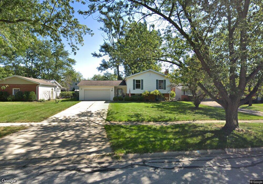
7317 Bunker Rd Darien, IL 60561
Estimated Value: $381,312 - $569,000
Studio
--
Bath
1,302
Sq Ft
$361/Sq Ft
Est. Value
About This Home
This home is located at 7317 Bunker Rd, Darien, IL 60561 and is currently estimated at $470,078, approximately $361 per square foot. 7317 Bunker Rd is a home located in DuPage County with nearby schools including Mark Delay School, Lace Elementary School, and Eisenhower Jr High School.
Ownership History
Date
Name
Owned For
Owner Type
Purchase Details
Closed on
Aug 22, 2017
Sold by
Erdmann Mark J and Erdmann Jenny L
Bought by
Erdmann Jenny L and Erdmann Mark J
Current Estimated Value
Purchase Details
Closed on
Jun 30, 1995
Sold by
Zmrhal Roger G and Zmrhal Joan
Bought by
Erdmann Mark J and Timpf Jenny
Home Financials for this Owner
Home Financials are based on the most recent Mortgage that was taken out on this home.
Original Mortgage
$142,400
Interest Rate
7.9%
Create a Home Valuation Report for This Property
The Home Valuation Report is an in-depth analysis detailing your home's value as well as a comparison with similar homes in the area
Home Values in the Area
Average Home Value in this Area
Purchase History
| Date | Buyer | Sale Price | Title Company |
|---|---|---|---|
| Erdmann Jenny L | -- | Attorney | |
| Erdmann Mark J | $178,000 | Intercounty Title |
Source: Public Records
Mortgage History
| Date | Status | Borrower | Loan Amount |
|---|---|---|---|
| Closed | Erdmann Mark J | $142,400 |
Source: Public Records
Tax History
| Year | Tax Paid | Tax Assessment Tax Assessment Total Assessment is a certain percentage of the fair market value that is determined by local assessors to be the total taxable value of land and additions on the property. | Land | Improvement |
|---|---|---|---|---|
| 2024 | $7,632 | $126,446 | $44,959 | $81,487 |
| 2023 | $7,346 | $116,240 | $41,330 | $74,910 |
| 2022 | $7,220 | $113,850 | $40,480 | $73,370 |
| 2021 | $6,945 | $112,560 | $40,020 | $72,540 |
| 2020 | $6,852 | $110,330 | $39,230 | $71,100 |
| 2019 | $6,622 | $105,860 | $37,640 | $68,220 |
| 2018 | $6,184 | $100,000 | $37,370 | $62,630 |
| 2017 | $6,122 | $96,230 | $35,960 | $60,270 |
| 2016 | $5,874 | $91,840 | $34,320 | $57,520 |
| 2015 | $5,788 | $86,410 | $32,290 | $54,120 |
| 2014 | $5,480 | $81,030 | $31,390 | $49,640 |
| 2013 | $5,298 | $80,650 | $31,240 | $49,410 |
Source: Public Records
Map
Nearby Homes
- 7525 Nantucket Dr Unit 210
- 714 Walnut Dr Unit 205
- 18W025 73rd St
- 7209 Grant St
- 7706 Warwick Ave
- 6808 Scotch Pine Trail
- 18W089 Claremont Dr
- 7700 Apple Tree Ln
- 7800 Dorchester Ln
- 7802 Warwick Ave
- 310 Sheridan Dr Unit 1D
- 7725 Sawyer Rd
- 7816 Dorchester Ln
- 1013 Torrey Pines Ct
- 321 Janet Ave
- 709 79th St Unit 408
- 6925 Clarendon Hills Rd
- 1109 Ponderosa Ct
- 1117 Bristlecone Ct
- 1156 Bristlecone Ct
- 7321 Bunker Rd
- 7313 Bunker Rd
- 7318 Richmond Ave
- 7325 Bunker Rd
- 7322 Richmond Ave
- 7309 Bunker Rd
- 7314 Richmond Ave
- 7318 Bunker Rd
- 7310 Richmond Ave
- 7326 Richmond Ave
- 7314 Bunker Rd
- 7322 Bunker Rd
- 7329 Bunker Rd
- 7310 Bunker Rd
- 7305 Bunker Rd
- 7330 Richmond Ave
- 7326 Bunker Rd
- 7306 Richmond Ave
- 7306 Bunker Rd
- 7333 Bunker Rd
Your Personal Tour Guide
Ask me questions while you tour the home.