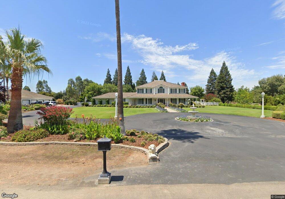
7345 N Paula Ave Clovis, CA 93611
Woodward Park NeighborhoodEstimated Value: $1,301,000 - $1,318,496
4
Beds
4
Baths
5,002
Sq Ft
$262/Sq Ft
Est. Value
About This Home
This home is located at 7345 N Paula Ave, Clovis, CA 93611 and is currently estimated at $1,309,748, approximately $261 per square foot. 7345 N Paula Ave is a home located in Fresno County with nearby schools including Mountain View Elementary School, Granite Ridge Intermediate School, and Clovis North High School.
Ownership History
Date
Name
Owned For
Owner Type
Purchase Details
Closed on
Oct 24, 2005
Sold by
Buchheim Arthur D and Buchheim Kay L
Bought by
Buchheim Arthur D and Buchheim Kay L
Current Estimated Value
Home Financials for this Owner
Home Financials are based on the most recent Mortgage that was taken out on this home.
Original Mortgage
$741,300
Interest Rate
5.87%
Mortgage Type
Unknown
Purchase Details
Closed on
Oct 13, 1998
Sold by
Buchheim Arthur D and Buchheim Kay L
Bought by
Buchheim Arthur D and Buchheim Kay L
Create a Home Valuation Report for This Property
The Home Valuation Report is an in-depth analysis detailing your home's value as well as a comparison with similar homes in the area
Home Values in the Area
Average Home Value in this Area
Purchase History
| Date | Buyer | Sale Price | Title Company |
|---|---|---|---|
| Buchheim Arthur D | -- | Financial Title Company | |
| Buchheim Arthur D | -- | Financial Title Company | |
| Buchheim Arthur D | -- | -- |
Source: Public Records
Mortgage History
| Date | Status | Borrower | Loan Amount |
|---|---|---|---|
| Closed | Buchheim Arthur D | $741,300 |
Source: Public Records
Tax History
| Year | Tax Paid | Tax Assessment Tax Assessment Total Assessment is a certain percentage of the fair market value that is determined by local assessors to be the total taxable value of land and additions on the property. | Land | Improvement |
|---|---|---|---|---|
| 2025 | $11,269 | $942,771 | $206,408 | $736,363 |
| 2023 | $10,801 | $906,164 | $198,394 | $707,770 |
| 2022 | $10,579 | $888,397 | $194,504 | $693,893 |
| 2021 | $10,279 | $870,979 | $190,691 | $680,288 |
| 2020 | $10,236 | $862,049 | $188,736 | $673,313 |
| 2019 | $10,034 | $845,147 | $185,036 | $660,111 |
| 2018 | $9,812 | $828,576 | $181,408 | $647,168 |
| 2017 | $9,641 | $812,330 | $177,851 | $634,479 |
| 2016 | $9,301 | $796,403 | $174,364 | $622,039 |
| 2015 | $9,159 | $784,441 | $171,745 | $612,696 |
| 2014 | $8,990 | $769,076 | $168,381 | $600,695 |
Source: Public Records
Map
Nearby Homes
- 2669 E Sean Ave
- 2625 E Sean Ave
- 2549 E Jenny Ave
- 2658 E Alluvial Ave Unit 120
- 2658 E Alluvial Ave Unit 220
- 7236 N Bonadelle Ave
- 2991 E Cromwell Ave
- 684 W Chennault Ave
- 2873 E El Paso Ave
- 2740 E El Paso Ave
- 7634 N Dearing Ave
- 2324 E Fir Ave
- 602 W Mahogany Ln
- 2845 E Goshen Ave
- 7305 N Woodrow Ave
- 2545 E Goshen Ave
- 2404 E El Paso Ave
- 7835 N Matus Ave
- 2189 E Pinedale Ave
- 7396 N Price Ave
- 2660 E Birch Ave
- 7405 N Paula Ave
- 7305 N Paula Ave
- 7344 N Paula Ave
- 2644 E Birch Ave
- 2673 E Birch Ave
- 7304 N Paula Ave
- 7404 N Paula Ave
- 7232 N Stacia Ave
- 7465 N Paula Ave
- 7221 N Stacia Ave
- 2626 E Birch Ave
- 7212 N Stacia Ave
- 7464 N Paula Ave
- 7224 N Chris Ave
- 2717 E Alluvial Ave
- 7234 N Chris Ave
- 7251 N Willow Ave
- 7211 N Stacia Ave
- 7202 N Stacia Ave
Your Personal Tour Guide
Ask me questions while you tour the home.