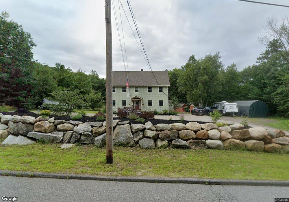
736 Ross Corner Rd Shapleigh, ME 04076
Shapleigh NeighborhoodEstimated Value: $323,813 - $570,000
4
Beds
3
Baths
2,700
Sq Ft
$169/Sq Ft
Est. Value
About This Home
This home is located at 736 Ross Corner Rd, Shapleigh, ME 04076 and is currently estimated at $455,703, approximately $168 per square foot. 736 Ross Corner Rd is a home located in York County with nearby schools including Massabesic High School.
Ownership History
Date
Name
Owned For
Owner Type
Purchase Details
Closed on
Apr 26, 2007
Sold by
Fleishman Carol
Bought by
Delapp Linda J and Delapp David S
Current Estimated Value
Home Financials for this Owner
Home Financials are based on the most recent Mortgage that was taken out on this home.
Original Mortgage
$177,200
Outstanding Balance
$107,844
Interest Rate
6.18%
Mortgage Type
Unknown
Estimated Equity
$347,859
Create a Home Valuation Report for This Property
The Home Valuation Report is an in-depth analysis detailing your home's value as well as a comparison with similar homes in the area
Home Values in the Area
Average Home Value in this Area
Purchase History
| Date | Buyer | Sale Price | Title Company |
|---|---|---|---|
| Delapp Linda J | -- | -- |
Source: Public Records
Mortgage History
| Date | Status | Borrower | Loan Amount |
|---|---|---|---|
| Open | Delapp Linda J | $35,000 | |
| Open | Delapp Linda J | $177,200 |
Source: Public Records
Tax History Compared to Growth
Tax History
| Year | Tax Paid | Tax Assessment Tax Assessment Total Assessment is a certain percentage of the fair market value that is determined by local assessors to be the total taxable value of land and additions on the property. | Land | Improvement |
|---|---|---|---|---|
| 2024 | $3,160 | $262,218 | $48,060 | $214,158 |
| 2023 | $2,780 | $262,218 | $48,060 | $214,158 |
| 2022 | $2,701 | $262,218 | $48,060 | $214,158 |
| 2021 | $2,688 | $262,218 | $48,060 | $214,158 |
| 2020 | $2,688 | $262,218 | $48,060 | $214,158 |
| 2019 | $2,662 | $262,218 | $48,060 | $214,158 |
| 2018 | $2,575 | $233,060 | $33,034 | $200,026 |
| 2017 | $2,489 | $233,060 | $33,034 | $200,026 |
| 2016 | $2,401 | $233,060 | $33,034 | $200,026 |
| 2015 | $2,331 | $233,060 | $33,034 | $200,026 |
| 2014 | $2,249 | $233,060 | $33,034 | $200,026 |
Source: Public Records
Map
Nearby Homes
- 1310 West Rd
- 52 Long Causeway
- 32 Northeast Rd
- 69 Bernier Ln
- 205 Blueberry Rd
- 255 Ross Corner Rd
- Lot 14 Milk Rd
- 350 Pine Springs Rd
- 48A Blueberry Rd
- 471 Owls Nest Rd
- 9 Restful Way
- Lot 35A Norton Ridge Rd
- 585 Newfield Rd
- 30 Swan Cir
- 92 Perch
- 282 Granny Kent Pond Rd
- 1304 Middle Rd
- 152 Hanson Rd
- M13L30 Clarks Bridge Rd
- 19 White Tail Ln
- 1788 Gore Rd
- 0 Lot B Newfield
- 0 Lot C Newfield
- 733 Ross Corner Rd
- 14 Newfield Rd
- 0 Newfield Rd Unit 665089
- 0 Newfield Rd Unit 548575
- 0 Newfield Rd Unit 226666
- 0 Newfield Rd Unit 630521
- 0 Newfield Rd Unit 469729
- 0 Newfield Rd Unit 546045
- 0 Newfield Rd Unit 254191
- 0 Newfield Rd Unit 254190
- 0 Newfield Rd Unit 207255
- 0 Newfield Rd Unit 227836
- 0 Newfield Rd Unit 200800
- 0 Newfield Rd Unit 382075
- 0 Newfield Rd Unit 263915
- 0 Newfield Rd Unit 262932
- 0 Newfield Rd Unit 153888