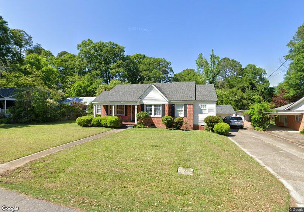
737 N Park St Laurel, MS 39440
Estimated Value: $153,776 - $210,000
Studio
1
Bath
1,555
Sq Ft
$120/Sq Ft
Est. Value
About This Home
This home is located at 737 N Park St, Laurel, MS 39440 and is currently estimated at $186,944, approximately $120 per square foot. 737 N Park St is a home located in Jones County with nearby schools including Mason Elementary School, Laurel Middle School, and Laurel High School.
Ownership History
Date
Name
Owned For
Owner Type
Purchase Details
Closed on
Oct 3, 2019
Sold by
Johnson Luke Sumrall and Johnson Donna Lauren
Bought by
Walters Zachary Tyler and Walters Brittni Elaine
Current Estimated Value
Home Financials for this Owner
Home Financials are based on the most recent Mortgage that was taken out on this home.
Original Mortgage
$108,080
Outstanding Balance
$94,277
Interest Rate
3.4%
Mortgage Type
Unknown
Estimated Equity
$92,667
Purchase Details
Closed on
Aug 3, 2011
Sold by
Ainsworth John H and Ainsworth Elizabeth Anne
Bought by
Johnson Luke Sumrall and Johnson Donna Lauren
Home Financials for this Owner
Home Financials are based on the most recent Mortgage that was taken out on this home.
Original Mortgage
$66,500,000
Interest Rate
4.52%
Create a Home Valuation Report for This Property
The Home Valuation Report is an in-depth analysis detailing your home's value as well as a comparison with similar homes in the area
Purchase History
| Date | Buyer | Sale Price | Title Company |
|---|---|---|---|
| Walters Zachary Tyler | -- | -- | |
| Johnson Luke Sumrall | -- | -- |
Source: Public Records
Mortgage History
| Date | Status | Borrower | Loan Amount |
|---|---|---|---|
| Open | Walters Zachary Tyler | $108,080 | |
| Previous Owner | Johnson Luke Sumrall | $66,500,000 |
Source: Public Records
Tax History
| Year | Tax Paid | Tax Assessment Tax Assessment Total Assessment is a certain percentage of the fair market value that is determined by local assessors to be the total taxable value of land and additions on the property. | Land | Improvement |
|---|---|---|---|---|
| 2025 | $1,028 | $7,543 | $0 | $0 |
| 2024 | $941 | $7,005 | $0 | $0 |
| 2023 | $941 | $7,005 | $0 | $0 |
| 2022 | $921 | $6,962 | $0 | $0 |
| 2021 | $928 | $6,962 | $0 | $0 |
| 2020 | $938 | $6,961 | $0 | $0 |
| 2019 | $943 | $6,961 | $0 | $0 |
| 2018 | $916 | $6,961 | $0 | $0 |
| 2017 | $916 | $6,961 | $0 | $0 |
| 2016 | $867 | $6,958 | $0 | $0 |
| 2015 | $826 | $6,958 | $0 | $0 |
| 2014 | $826 | $6,958 | $0 | $0 |
Source: Public Records
Map
Nearby Homes
- 2503 Old Bay Springs Rd
- 852, 848 N 7th Ave
- 2335 N 7th Ave
- 45 Broadmoor Dr
- 2732 Carter Ave
- 2820 Old Bay Springs Rd
- 2140 N 7th Ave
- 2216 Old Bay Springs Rd
- 617 W 21st St
- 2230 Ridgewood Dr
- 1332 Parker Dr
- 1159 W 20th St
- 3231 Pinehaven Dr
- 2270 N 1st Ave
- 1524 Parker
- 2228 N 1st Ave
- 3227 Audubon Dr
- 1242 W 18th St
- 11 & 12 Shamroque Dr
- 1428 33rd St
Your Personal Tour Guide
Ask me questions while you tour the home.