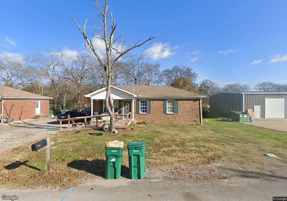
738 Crestland St Lewisburg, TN 37091
Estimated Value: $192,000 - $228,000
--
Bed
1
Bath
1,008
Sq Ft
$208/Sq Ft
Est. Value
About This Home
This home is located at 738 Crestland St, Lewisburg, TN 37091 and is currently estimated at $209,948, approximately $208 per square foot. 738 Crestland St is a home located in Marshall County with nearby schools including Marshall Elementary School, Oak Grove Elementary School, and Westhills Elementary School.
Ownership History
Date
Name
Owned For
Owner Type
Purchase Details
Closed on
Feb 21, 2013
Sold by
Bank Of Frankewing
Bought by
Perryman Investments Llc
Current Estimated Value
Purchase Details
Closed on
Mar 19, 2012
Sold by
Love Gary Wayne
Bought by
Bank Of Frankewing
Purchase Details
Closed on
Jun 11, 2008
Bought by
Love Gary Wayne and Love Elizabeth Clair
Purchase Details
Closed on
Dec 7, 2007
Sold by
Patrick Smith
Bought by
Bank Of Frankewing
Purchase Details
Closed on
Apr 16, 2002
Bought by
Pat Smith and Smith Patirck E
Purchase Details
Closed on
Sep 8, 1998
Sold by
William Carter
Bought by
Patrick Smith and Patrick Annette
Create a Home Valuation Report for This Property
The Home Valuation Report is an in-depth analysis detailing your home's value as well as a comparison with similar homes in the area
Home Values in the Area
Average Home Value in this Area
Purchase History
| Date | Buyer | Sale Price | Title Company |
|---|---|---|---|
| Perryman Investments Llc | $15,000 | -- | |
| Bank Of Frankewing | $675,000 | -- | |
| Love Gary Wayne | $1,100,000 | -- | |
| Bank Of Frankewing | $115,400 | -- | |
| Pat Smith | -- | -- | |
| Patrick Smith | $4,200 | -- |
Source: Public Records
Tax History Compared to Growth
Tax History
| Year | Tax Paid | Tax Assessment Tax Assessment Total Assessment is a certain percentage of the fair market value that is determined by local assessors to be the total taxable value of land and additions on the property. | Land | Improvement |
|---|---|---|---|---|
| 2024 | -- | $37,325 | $4,000 | $33,325 |
| 2023 | $1,159 | $37,325 | $4,000 | $33,325 |
| 2022 | $1,159 | $37,325 | $4,000 | $33,325 |
| 2021 | $985 | $21,175 | $2,000 | $19,175 |
| 2020 | $985 | $21,175 | $2,000 | $19,175 |
| 2019 | $953 | $21,175 | $2,000 | $19,175 |
| 2018 | $943 | $21,175 | $2,000 | $19,175 |
| 2017 | $943 | $21,175 | $2,000 | $19,175 |
| 2016 | $557 | $10,875 | $1,950 | $8,925 |
| 2015 | $91 | $1,950 | $1,950 | $0 |
| 2014 | $91 | $1,950 | $1,950 | $0 |
Source: Public Records
Map
Nearby Homes
- 301 East Ave
- 755 Center St
- 224 Hardison Ave
- 126 Armory Dr
- 125 Armory Dr
- 535 Clayton Ave
- 330 Hickory Cir
- 411 Elm Ave
- 391 Elm Ave
- 131 Isabela Dr
- 141 Isabela Dr
- 319 E Hill Ave
- 188 Trey Dr
- 380 Baxter Ave
- 1351 Old Belfast Rd
- 3019 Cambridge Ct
- 3021 Cambridge Ct
- 155 Landon Ln
- 1183 Finley Beech Rd
- 198 Creekside Dr
- 728 Crestland St
- 720 Crestland St
- 725 Crestland St
- 735 Crestland St
- 712 Crestland St
- 719 Crestland St
- 745 Crestland St
- 480 S Ellington Pkwy
- 761 Belfast St
- 755 Belfast St
- 721 Crestland St
- 811 Belfast St
- 693 Crestland St
- 749 Belfast St
- 690 Crestland St
- 743 Belfast St
- 691 Crestland St
- 793 Crestland St
- 686 Crestland St
- 737 Belfast St