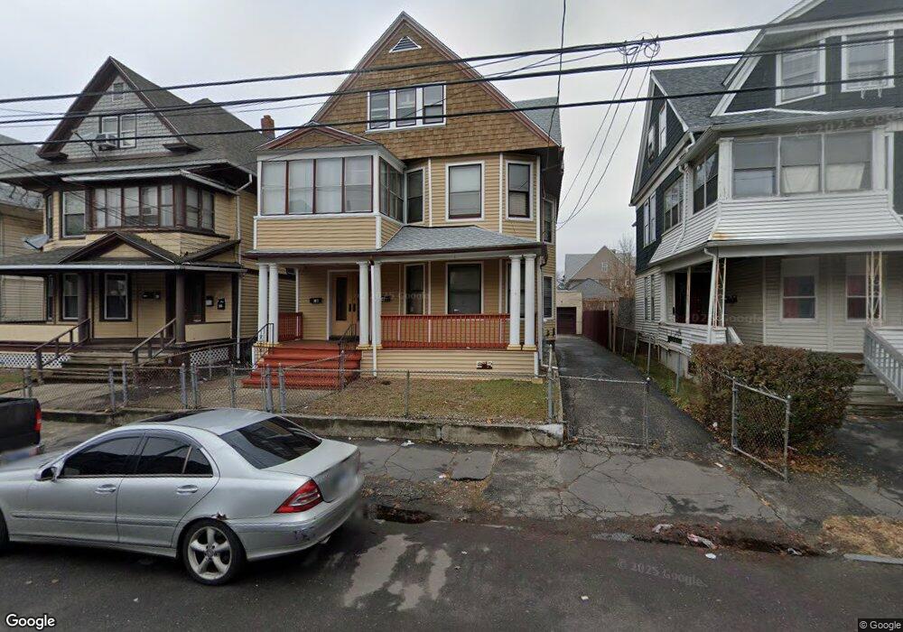
74 Poplar St Bridgeport, CT 06605
West End-West Side NeighborhoodEstimated Value: $485,000 - $618,000
5
Beds
3
Baths
3,403
Sq Ft
$160/Sq Ft
Est. Value
About This Home
This home is located at 74 Poplar St, Bridgeport, CT 06605 and is currently estimated at $543,854, approximately $159 per square foot. 74 Poplar St is a home located in Fairfield County with nearby schools including Bryant Elementary School, Bassick High School, and Park City Prep Charter School.
Ownership History
Date
Name
Owned For
Owner Type
Purchase Details
Closed on
May 5, 2015
Sold by
Oforma Charles
Bought by
Oforma Maurice
Current Estimated Value
Purchase Details
Closed on
Jul 10, 1992
Sold by
Decarlo Gary
Bought by
Oforma Maurice
Home Financials for this Owner
Home Financials are based on the most recent Mortgage that was taken out on this home.
Original Mortgage
$94,400
Interest Rate
8.56%
Mortgage Type
Purchase Money Mortgage
Create a Home Valuation Report for This Property
The Home Valuation Report is an in-depth analysis detailing your home's value as well as a comparison with similar homes in the area
Home Values in the Area
Average Home Value in this Area
Purchase History
| Date | Buyer | Sale Price | Title Company |
|---|---|---|---|
| Oforma Maurice | -- | -- | |
| Oforma Maurice | $118,000 | -- |
Source: Public Records
Mortgage History
| Date | Status | Borrower | Loan Amount |
|---|---|---|---|
| Previous Owner | Oforma Maurice | $14,800 | |
| Previous Owner | Oforma Maurice | $94,400 |
Source: Public Records
Tax History Compared to Growth
Tax History
| Year | Tax Paid | Tax Assessment Tax Assessment Total Assessment is a certain percentage of the fair market value that is determined by local assessors to be the total taxable value of land and additions on the property. | Land | Improvement |
|---|---|---|---|---|
| 2025 | $8,435 | $194,140 | $50,190 | $143,950 |
| 2024 | $8,435 | $194,140 | $50,190 | $143,950 |
| 2023 | $8,435 | $194,140 | $50,190 | $143,950 |
| 2022 | $8,435 | $194,140 | $50,190 | $143,950 |
| 2021 | $8,435 | $194,140 | $50,190 | $143,950 |
| 2020 | $7,698 | $142,580 | $30,420 | $112,160 |
| 2019 | $7,698 | $142,580 | $30,420 | $112,160 |
| 2018 | $7,752 | $142,580 | $30,420 | $112,160 |
| 2017 | $7,752 | $142,580 | $30,420 | $112,160 |
| 2016 | $7,752 | $142,580 | $30,420 | $112,160 |
| 2015 | $7,722 | $182,990 | $46,000 | $136,990 |
| 2014 | $7,722 | $182,990 | $46,000 | $136,990 |
Source: Public Records
Map
Nearby Homes
- 99 Denver Ave Unit 101
- 899 Hancock Ave
- 115 Denver Ave Unit 117
- 468 Colorado Ave
- 47 Lenox Ave
- 255 Poplar St
- 212 Denver Ave
- 195 Lenox Ave Unit 197
- 1059 Hancock Ave Unit 1061
- 533 Clinton Ave
- 203 Lenox Ave Unit 205
- 246 Lenox Ave
- 725 Beechwood Ave Unit 727
- 670 Clinton Ave
- 412 Dewey St
- 368 Lenox Ave
- 500 Dewey St
- 85 Ash St
- 95 Bedford Ave
- 74 Carleton Ave