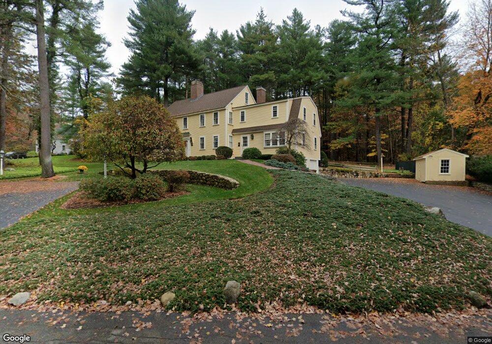
74 Ruddock Rd Sudbury, MA 01776
Estimated Value: $1,223,000 - $1,551,000
5
Beds
3
Baths
3,484
Sq Ft
$412/Sq Ft
Est. Value
About This Home
This home is located at 74 Ruddock Rd, Sudbury, MA 01776 and is currently estimated at $1,436,310, approximately $412 per square foot. 74 Ruddock Rd is a home located in Middlesex County with nearby schools including Josiah Haynes Elementary School, Ephraim Curtis Middle School, and Lincoln-Sudbury Regional High School.
Ownership History
Date
Name
Owned For
Owner Type
Purchase Details
Closed on
Apr 2, 2024
Sold by
Healy Sarah A
Bought by
Sarah A Healy 2006 Ret and Healy
Current Estimated Value
Purchase Details
Closed on
Oct 29, 1968
Bought by
Healy James J and Healy Sarah A
Create a Home Valuation Report for This Property
The Home Valuation Report is an in-depth analysis detailing your home's value as well as a comparison with similar homes in the area
Home Values in the Area
Average Home Value in this Area
Purchase History
| Date | Buyer | Sale Price | Title Company |
|---|---|---|---|
| Sarah A Healy 2006 Ret | -- | None Available | |
| Healy James J | -- | -- |
Source: Public Records
Mortgage History
| Date | Status | Borrower | Loan Amount |
|---|---|---|---|
| Previous Owner | Healy James J | $500,000 | |
| Previous Owner | Healy James J | $250,000 | |
| Previous Owner | Healy James J | $150,000 |
Source: Public Records
Tax History Compared to Growth
Tax History
| Year | Tax Paid | Tax Assessment Tax Assessment Total Assessment is a certain percentage of the fair market value that is determined by local assessors to be the total taxable value of land and additions on the property. | Land | Improvement |
|---|---|---|---|---|
| 2025 | $19,713 | $1,346,500 | $508,000 | $838,500 |
| 2024 | $19,000 | $1,300,500 | $493,600 | $806,900 |
| 2023 | $17,576 | $1,114,500 | $441,600 | $672,900 |
| 2022 | $16,875 | $934,900 | $405,600 | $529,300 |
| 2021 | $15,915 | $845,200 | $405,600 | $439,600 |
| 2020 | $15,594 | $845,200 | $405,600 | $439,600 |
| 2019 | $15,138 | $845,200 | $405,600 | $439,600 |
| 2018 | $14,880 | $829,900 | $431,200 | $398,700 |
| 2017 | $14,588 | $822,300 | $427,600 | $394,700 |
| 2016 | $14,133 | $794,000 | $411,600 | $382,400 |
| 2015 | $13,628 | $774,300 | $400,000 | $374,300 |
| 2014 | $13,490 | $748,200 | $388,400 | $359,800 |
Source: Public Records
Map
Nearby Homes
- 5 Taintor Dr
- 55 Widow Rites Ln
- 45 Widow Rites Ln
- 57 Longfellow Rd
- 166 Parker St Unit 4
- 54 Phillips Rd
- 63 Canterbury Dr
- 589 North Rd
- 12 Camperdown Ln
- 250 Great Rd
- 10 Oak Ridge Dr Unit 5
- 67 Powder Mill Rd
- 5 Oak Ridge Dr Unit 7
- 16 Blacksmith Dr
- 42 Dakin Rd
- 36 Old Forge Ln
- 47 Fairbank Rd
- 24 Goodnow Rd
- 11 Barnet Rd
- 14 Frost Ln