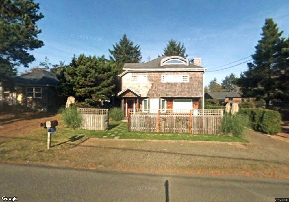
740 F St Gearhart, OR 97138
Estimated Value: $662,247 - $741,000
3
Beds
2
Baths
1,732
Sq Ft
$406/Sq Ft
Est. Value
About This Home
This home is located at 740 F St, Gearhart, OR 97138 and is currently estimated at $703,562, approximately $406 per square foot. 740 F St is a home located in Clatsop County with nearby schools including Seaside High School.
Ownership History
Date
Name
Owned For
Owner Type
Purchase Details
Closed on
Jul 17, 2024
Sold by
Jacobsen David P and Jacobsen Gay B
Bought by
Jacobsen Family Trust and Jacobsen
Current Estimated Value
Purchase Details
Closed on
Oct 17, 2016
Sold by
Jacobsen David and Jacobsen Gay B
Bought by
Second Wind Beach Llc
Purchase Details
Closed on
Sep 1, 2005
Sold by
Jacobsen Gay Burnie
Bought by
Jacobsen David P and Jacobsen Gay Burnie
Create a Home Valuation Report for This Property
The Home Valuation Report is an in-depth analysis detailing your home's value as well as a comparison with similar homes in the area
Home Values in the Area
Average Home Value in this Area
Purchase History
| Date | Buyer | Sale Price | Title Company |
|---|---|---|---|
| Jacobsen Family Trust | -- | None Listed On Document | |
| Jacobsen David P | -- | None Listed On Document | |
| Second Wind Beach Llc | -- | None Available | |
| Jacobsen David P | -- | -- |
Source: Public Records
Tax History Compared to Growth
Tax History
| Year | Tax Paid | Tax Assessment Tax Assessment Total Assessment is a certain percentage of the fair market value that is determined by local assessors to be the total taxable value of land and additions on the property. | Land | Improvement |
|---|---|---|---|---|
| 2025 | $3,704 | $339,091 | -- | -- |
| 2024 | $3,765 | $329,215 | -- | -- |
| 2023 | $3,660 | $319,628 | $0 | $0 |
| 2022 | $3,550 | $310,320 | $0 | $0 |
| 2021 | $3,624 | $301,282 | $0 | $0 |
| 2020 | $3,496 | $292,508 | $0 | $0 |
| 2019 | $3,406 | $283,989 | $0 | $0 |
| 2018 | $3,283 | $275,718 | $0 | $0 |
| 2017 | $3,196 | $267,688 | $0 | $0 |
| 2016 | $2,760 | $259,893 | $74,533 | $185,360 |
| 2015 | $2,654 | $252,325 | $72,363 | $179,962 |
| 2014 | $2,538 | $244,977 | $0 | $0 |
| 2013 | -- | $237,843 | $0 | $0 |
Source: Public Records
Map
Nearby Homes
- 1265 D St
- 782 Woodland Ct
- 0 Wellington Ave Unit 25-48
- 0 Wellington Ave Unit 1202
- 196 Dylan Ct
- 735 3rd St
- 3387-3389 U S 101
- 3389 U S 101
- 2624 Neawanna St
- 000 Neawanna St
- 802 25th Ave
- 1396 N Ocean Ave
- 2657 N Hwy 101 Unit 6
- 1065 Picture Place
- 1054 Picture Place
- 1324 Sea Ridge Ln
- 101 13th St Unit 209
- 856 Neacoxie Blvd
- 856 Neacoxie Blvd Unit 311
- 1146 N Marion Ave Unit 1-606