
Seller's Agent in 2025
Brian Carlson
Windermere West LLC
(503) 686-4396
50 Total Sales
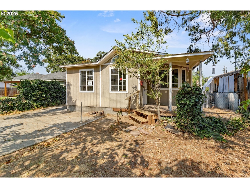


FINAL CALL FOR OFFERS!!! All offers due 9/14/2025 by 5:00 PM Pacific. This 900+ SF bungalow offers classic character and endless potential with 2 bedrooms and 1 bathroom. Featuring a welcoming covered entry and a fenced yard, this property is perfect for those looking to customize their own space. Whether you’re an investor or a buyer with a vision, this home is ready to be transformed into something special. Property sold "As-is". Buyer and/or buyer's agent responsible for verifying all pertinent information deemed relevant by the prospective buyer, including but not limited to square footage, acreage, utilities, taxes, zoning, permitting, condition, school zones, HOAs, etc.
Last Agent to Sell the Property
Windermere West LLC License #841100037 Listed on: 08/26/2025
| Date | Type | Sale Price | Title Company |
|---|---|---|---|
| Special Warranty Deed | $150,000 | Amerititle | |
| Trustee Deed | $170,272 | None Available | |
| Warranty Deed | $151,500 | First American | |
| Warranty Deed | $93,000 | Amerititle |
| Date | Status | Loan Amount | Loan Type |
|---|---|---|---|
| Previous Owner | $149,159 | FHA | |
| Previous Owner | $83,607 | No Value Available |
| Date | Event | Price | List to Sale | Price per Sq Ft |
|---|---|---|---|---|
| 12/11/2025 12/11/25 | Sold | $150,000 | +1.0% | $158 / Sq Ft |
| 09/18/2025 09/18/25 | Pending | -- | -- | -- |
| 08/26/2025 08/26/25 | For Sale | $148,500 | -- | $156 / Sq Ft |
| Year | Tax Paid | Tax Assessment Tax Assessment Total Assessment is a certain percentage of the fair market value that is determined by local assessors to be the total taxable value of land and additions on the property. | Land | Improvement |
|---|---|---|---|---|
| 2026 | $343 | -- | -- | -- |
| 2025 | $2,489 | -- | -- | -- |
| 2024 | $2,489 | $121,380 | $63,540 | $57,840 |
| 2023 | $2,341 | $117,850 | $61,690 | $56,160 |
| 2022 | $1,965 | $117,850 | $61,690 | $56,160 |
| 2021 | $1,909 | $114,420 | $59,900 | $54,520 |
| 2020 | $1,853 | $111,090 | $58,160 | $52,930 |
| 2019 | $1,807 | $104,720 | $54,810 | $49,910 |
| 2018 | $1,752 | $101,670 | $53,210 | $48,460 |
| 2017 | $1,708 | $101,670 | $53,210 | $48,460 |
| 2016 | $1,658 | $95,840 | $50,160 | $45,680 |
| 2015 | $1,589 | $95,840 | $50,160 | $45,680 |
| 2014 | $1,543 | $90,340 | $47,270 | $43,070 |
Seller's Agent in 2025
Brian Carlson
Windermere West LLC
(503) 686-4396
50 Total Sales
Seller Co-Listing Agent in 2025
ADAM JOHNSON
Windermere West LLC, Newberg
(605) 639-5851
108 Total Sales
O
Buyer's Agent in 2025
OR and WA Non Rmls
Non Rmls Broker
Source: Regional Multiple Listing Service (RMLS)
MLS Number: 125248081
APN: 10138434
Disclaimer: Certain information contained herein is derived from information provided by parties other than Homes.com. All information provided is deemed reliable, but is not guaranteed to be accurate and should be independently verified.
![]() The content relating to real estate for sale on this web site comes in part from the IDX program of the RMLS™ of Portland, Oregon. Real estate listings held by brokerage firms other than Ten-X are marked with the RMLS™ logo, and detailed information about these properties includes the names of the listing brokers. Listing content is copyright © 2025 RMLS™, Portland, Oregon. Some properties which appear for sale on this web site may subsequently have sold or may no longer be available. All information provided is deemed reliable but is not guaranteed and should be independently verified.
The content relating to real estate for sale on this web site comes in part from the IDX program of the RMLS™ of Portland, Oregon. Real estate listings held by brokerage firms other than Ten-X are marked with the RMLS™ logo, and detailed information about these properties includes the names of the listing brokers. Listing content is copyright © 2025 RMLS™, Portland, Oregon. Some properties which appear for sale on this web site may subsequently have sold or may no longer be available. All information provided is deemed reliable but is not guaranteed and should be independently verified.