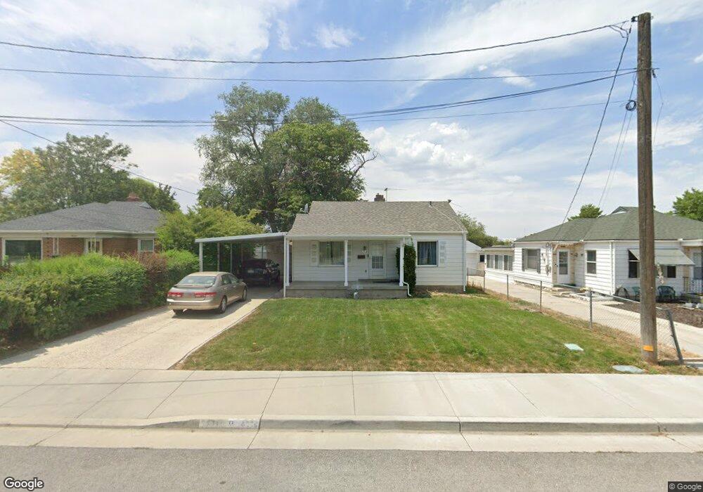
7412 Maple St Midvale, UT 84047
Estimated Value: $412,164 - $437,000
2
Beds
1
Bath
754
Sq Ft
$561/Sq Ft
Est. Value
About This Home
This home is located at 7412 Maple St, Midvale, UT 84047 and is currently estimated at $422,791, approximately $560 per square foot. 7412 Maple St is a home located in Salt Lake County with nearby schools including East Midvale Elementary School, Midvale Middle School, and Hillcrest High School.
Ownership History
Date
Name
Owned For
Owner Type
Purchase Details
Closed on
Nov 9, 2020
Sold by
Motley Judith J
Bought by
Dj Yates Trust and Yates
Current Estimated Value
Purchase Details
Closed on
Nov 6, 2020
Sold by
Motley Judith J
Bought by
Yates David B and Yates Jennifer K
Purchase Details
Closed on
Sep 17, 1999
Sold by
Motley Judith J
Bought by
Motley W Wayne and Motley Judith J
Home Financials for this Owner
Home Financials are based on the most recent Mortgage that was taken out on this home.
Original Mortgage
$82,400
Interest Rate
11.12%
Create a Home Valuation Report for This Property
The Home Valuation Report is an in-depth analysis detailing your home's value as well as a comparison with similar homes in the area
Home Values in the Area
Average Home Value in this Area
Purchase History
| Date | Buyer | Sale Price | Title Company |
|---|---|---|---|
| Dj Yates Trust | -- | None Listed On Document | |
| Yates David B | -- | None Available | |
| Motley W Wayne | -- | Backman Stewart Title Servic | |
| Motley Judith J | -- | Backman Stewart Title Servic |
Source: Public Records
Mortgage History
| Date | Status | Borrower | Loan Amount |
|---|---|---|---|
| Previous Owner | Motley Judith J | $82,400 |
Source: Public Records
Tax History Compared to Growth
Tax History
| Year | Tax Paid | Tax Assessment Tax Assessment Total Assessment is a certain percentage of the fair market value that is determined by local assessors to be the total taxable value of land and additions on the property. | Land | Improvement |
|---|---|---|---|---|
| 2025 | -- | $372,300 | $137,000 | $235,300 |
| 2024 | -- | $318,900 | $130,100 | $188,800 |
| 2023 | $1,833 | $298,200 | $123,600 | $174,600 |
| 2022 | $1,966 | $312,500 | $121,200 | $191,300 |
| 2021 | $1,745 | $237,100 | $111,100 | $126,000 |
| 2020 | $1,656 | $212,900 | $80,800 | $132,100 |
| 2019 | $1,403 | $175,800 | $72,100 | $103,700 |
| 2016 | $1,337 | $157,900 | $72,100 | $85,800 |
Source: Public Records
Map
Nearby Homes
- 7571 S Blisswood Dr #20 Dr Unit 20
- 8136 Cottonwood St
- 72 E 7320 S
- 7373 S Wood Lily Ct Unit 24
- 7369 S Wood Lily Ct Unit 23
- 7365 S Wood Lily Ct Unit 22
- 7361 S Wood Lily Ct Unit 21
- 7357 S Wood Lily Ct Unit 20
- 7353 S Wood Lily Ct Unit 19
- 7331 S Seven Tree Ln Unit 84
- 7333 S Seven Tree Ln Unit 83
- 353 W 6th Ave
- 7370 S Wood Lily Ct Unit 26
- 7366 S Wood Lily Ct Unit 27
- 7362 S Wood Lily Ct Unit 28
- 7358 S Wood Lily Ct Unit 29
- 7354 S Wood Lily Ct Unit 30
- 7332 S Seven Tree Ln Unit 73
- 7330 S Seven Tree Ln Unit 72
- 7588 S Jefferson St