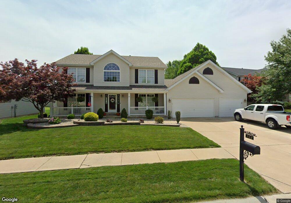
743 Sheffield Chase Dr Saint Peters, MO 63376
Estimated Value: $503,612 - $594,000
4
Beds
3
Baths
2,694
Sq Ft
$200/Sq Ft
Est. Value
About This Home
This home is located at 743 Sheffield Chase Dr, Saint Peters, MO 63376 and is currently estimated at $539,653, approximately $200 per square foot. 743 Sheffield Chase Dr is a home located in St. Charles County with nearby schools including Progress South Elementary School, Fort Zumwalt South Middle School, and Fort Zumwalt South High School.
Ownership History
Date
Name
Owned For
Owner Type
Purchase Details
Closed on
Feb 21, 1997
Sold by
Tom Johnson Construction Company Inc
Bought by
Halterman Eric M and Halterman Deborah L
Current Estimated Value
Home Financials for this Owner
Home Financials are based on the most recent Mortgage that was taken out on this home.
Original Mortgage
$145,400
Outstanding Balance
$16,929
Interest Rate
7.89%
Mortgage Type
Assumption
Estimated Equity
$522,724
Create a Home Valuation Report for This Property
The Home Valuation Report is an in-depth analysis detailing your home's value as well as a comparison with similar homes in the area
Home Values in the Area
Average Home Value in this Area
Purchase History
| Date | Buyer | Sale Price | Title Company |
|---|---|---|---|
| Halterman Eric M | $181,800 | -- |
Source: Public Records
Mortgage History
| Date | Status | Borrower | Loan Amount |
|---|---|---|---|
| Open | Halterman Eric M | $145,400 |
Source: Public Records
Tax History Compared to Growth
Tax History
| Year | Tax Paid | Tax Assessment Tax Assessment Total Assessment is a certain percentage of the fair market value that is determined by local assessors to be the total taxable value of land and additions on the property. | Land | Improvement |
|---|---|---|---|---|
| 2025 | $5,251 | $86,401 | -- | -- |
| 2023 | $5,256 | $79,986 | $0 | $0 |
| 2022 | $4,387 | $62,193 | $0 | $0 |
| 2021 | $4,398 | $62,193 | $0 | $0 |
| 2020 | $4,302 | $58,482 | $0 | $0 |
| 2019 | $4,312 | $58,482 | $0 | $0 |
| 2018 | $3,901 | $50,575 | $0 | $0 |
| 2017 | $3,846 | $50,575 | $0 | $0 |
| 2016 | $3,679 | $46,478 | $0 | $0 |
| 2015 | $3,405 | $46,152 | $0 | $0 |
| 2014 | $3,219 | $43,008 | $0 | $0 |
Source: Public Records
Map
Nearby Homes
- 661 Clifton Hill Dr
- 201 Dardenne Farms Dr
- 213 Black Oak Dr
- 6355 Sprucefield Dr
- 421 Jacobs Place Dr
- 120 Glenallen Dr
- 212 Jacobs Way
- 225 Jacobs Way
- 60 Loganberry Ct
- 1228 Cold Spring Dr
- 1218 Cold Spring Dr
- 1313 Commons Cir
- 1406 Colonial Dr
- 1 Pauley Cir
- 1700 Birdie Hills Rd
- 1017 Windsor Crest Ct
- 511 Roaring Fork Ct
- 0 the Rainier@weiss Rd
- 0 the Indigo@weiss Rd
- 178 Christina Marie Dr
- 741 Sheffield Chase Dr
- 745 Sheffield Chase Dr
- 744 Sheffield Chase Dr
- 742 Sheffield Chase Dr
- 412 Harrington Place
- 414 Harrington Place
- 747 Sheffield Chase Dr
- 740 Sheffield Chase Dr
- 746 Sheffield Chase Dr
- 416 Harrington Place
- 748 Sheffield Chase Dr
- 738 Sheffield Chase Dr
- 749 Sheffield Chase Dr
- 418 Harrington Place
- 411 Harrington Place
- 736 Sheffield Chase Dr
- 413 Harrington Place
- 12 South Trail
- 415 Harrington Place
- 14 South Trail