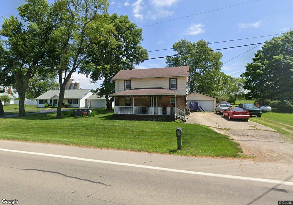
7435 S State Route 202 Tipp City, OH 45371
Estimated Value: $176,000 - $298,000
4
Beds
2
Baths
1,648
Sq Ft
$146/Sq Ft
Est. Value
About This Home
This home is located at 7435 S State Route 202, Tipp City, OH 45371 and is currently estimated at $240,109, approximately $145 per square foot. 7435 S State Route 202 is a home located in Miami County with nearby schools including Bethel Elementary School, Bethel Middle School, and Bethel High School.
Ownership History
Date
Name
Owned For
Owner Type
Purchase Details
Closed on
Jan 29, 2013
Sold by
Gasher William A
Bought by
Bank Of America Na
Current Estimated Value
Purchase Details
Closed on
Dec 10, 2012
Sold by
Gasher William A
Bought by
Bank Of America Na
Purchase Details
Closed on
Apr 3, 2006
Sold by
Hardy George and Hardy Beverly A
Bought by
Gasher William A
Purchase Details
Closed on
Sep 2, 2005
Sold by
Burns Kimberly
Bought by
Hardy George and Hardy Beverly A
Home Financials for this Owner
Home Financials are based on the most recent Mortgage that was taken out on this home.
Original Mortgage
$96,000
Interest Rate
5.82%
Mortgage Type
New Conventional
Purchase Details
Closed on
Mar 8, 2005
Sold by
Burns Christopher S
Bought by
Burns Kimberly L
Purchase Details
Closed on
Jan 1, 1990
Bought by
Burns Kash
Create a Home Valuation Report for This Property
The Home Valuation Report is an in-depth analysis detailing your home's value as well as a comparison with similar homes in the area
Home Values in the Area
Average Home Value in this Area
Purchase History
| Date | Buyer | Sale Price | Title Company |
|---|---|---|---|
| Bank Of America Na | $72,000 | Attorney | |
| Bank Of America Na | -- | None Available | |
| Gasher William A | $149,500 | -- | |
| Hardy George | $120,000 | -- | |
| Burns Kimberly L | -- | -- | |
| Burns Kash | -- | -- |
Source: Public Records
Mortgage History
| Date | Status | Borrower | Loan Amount |
|---|---|---|---|
| Previous Owner | Burns Kimberly L | $96,000 |
Source: Public Records
Tax History Compared to Growth
Tax History
| Year | Tax Paid | Tax Assessment Tax Assessment Total Assessment is a certain percentage of the fair market value that is determined by local assessors to be the total taxable value of land and additions on the property. | Land | Improvement |
|---|---|---|---|---|
| 2024 | $2,054 | $42,040 | $4,410 | $37,630 |
| 2023 | $2,054 | $42,040 | $4,410 | $37,630 |
| 2022 | $2,031 | $42,040 | $4,410 | $37,630 |
| 2021 | $1,816 | $35,040 | $3,680 | $31,360 |
| 2020 | $1,806 | $35,040 | $3,680 | $31,360 |
| 2019 | $1,826 | $35,040 | $3,680 | $31,360 |
| 2018 | $1,889 | $33,150 | $3,640 | $29,510 |
| 2017 | $1,848 | $33,150 | $3,640 | $29,510 |
| 2016 | $1,668 | $33,150 | $3,640 | $29,510 |
| 2015 | $1,660 | $31,890 | $3,500 | $28,390 |
| 2014 | $1,660 | $31,890 | $3,500 | $28,390 |
| 2013 | $1,473 | $31,890 | $3,500 | $28,390 |
Source: Public Records
Map
Nearby Homes
- 4320 Ginghamsburg West Charleston Rd
- 4019 Lupine Way
- 1037 Arbor Dr
- 4207 Forestedge St
- 8415 S State Route 202
- 7337 Ross Rd
- 0 Ohio 202 Unit 23014098
- 0 Ohio 202 Unit 23014095
- 6345 Ohio 202
- 5420 U S 40
- 9091 Jasmine Dr
- 5362 Windbrooke Dr
- 5195 Buttercup Dr
- 5068 Meadowview St
- 3005 Vervain Way
- 2003 Trillium Way
- 1349 Senna St
- 129 Solar Dr
- 4620 Cobblestone Dr Unit 4620
- 1117 Honeydew Dr
- 7435 Ohio 202
- 7445 S State Route 202
- 7415 S State Route 202
- 7467 S State Route 202
- 7430 S State Route 202
- 7460 S State Route 202
- 7485 S State Route 202
- 7485 Ohio 202
- 7385 S State Route 202
- 7470 S State Route 202
- 7487 S State Route 202
- 7390 S State Route 202
- 7480 S State Route 202
- 4490 Gnghmsbrg W Charlston Rd
- 7390 Ohio 202
- 7505 S State Route 202
- 4460 Gnghmsbrg W Charlston Rd
- 7355 S State Route 202
- 7355 Ohio 202
- 7500 S State Route 202