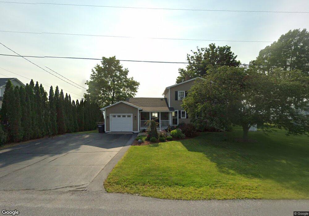
744 Maquam Shore Rd Swanton, VT 05488
Estimated Value: $662,000 - $817,019
3
Beds
3
Baths
2,024
Sq Ft
$368/Sq Ft
Est. Value
About This Home
This home is located at 744 Maquam Shore Rd, Swanton, VT 05488 and is currently estimated at $744,755, approximately $367 per square foot. 744 Maquam Shore Rd is a home located in Franklin County with nearby schools including St. Albans Town Educational Center.
Ownership History
Date
Name
Owned For
Owner Type
Purchase Details
Closed on
Jul 25, 2024
Sold by
Lamm Gayle and Lamm Dennis
Bought by
Mcginn Anne
Current Estimated Value
Purchase Details
Closed on
Oct 27, 2020
Sold by
Farley Billie J and Farley Cheryl M
Bought by
Lamm Dennis S and Lamm Gayle V
Purchase Details
Closed on
Jul 14, 2016
Sold by
Smith Stephen D and Smith Susan M
Bought by
Farley Billie J and Farley Cheryl A
Purchase Details
Closed on
Sep 4, 2014
Sold by
Beaulieu Robert and Beaulieu Sonya
Bought by
Smith Stephen D and Smith Susan M
Purchase Details
Closed on
Jun 22, 2001
Sold by
Needleman Mark A
Bought by
Beaulieu Robert C and Beaulieu Sonya J
Create a Home Valuation Report for This Property
The Home Valuation Report is an in-depth analysis detailing your home's value as well as a comparison with similar homes in the area
Home Values in the Area
Average Home Value in this Area
Purchase History
| Date | Buyer | Sale Price | Title Company |
|---|---|---|---|
| Mcginn Anne | $800,000 | -- | |
| Lamm Dennis S | $579,000 | -- | |
| Lamm Dennis S | $579,000 | -- | |
| Farley Billie J | $400,000 | -- | |
| Farley Billie J | $400,000 | -- | |
| Smith Stephen D | $335,900 | -- | |
| Smith Stephen D | $335,900 | -- | |
| Beaulieu Robert C | $223,000 | -- |
Source: Public Records
Tax History Compared to Growth
Tax History
| Year | Tax Paid | Tax Assessment Tax Assessment Total Assessment is a certain percentage of the fair market value that is determined by local assessors to be the total taxable value of land and additions on the property. | Land | Improvement |
|---|---|---|---|---|
| 2024 | -- | $399,200 | $170,200 | $229,000 |
| 2023 | -- | $399,200 | $170,200 | $229,000 |
| 2022 | $8,186 | $399,200 | $170,200 | $229,000 |
| 2021 | $7,892 | $399,200 | $170,200 | $229,000 |
| 2020 | $6,472 | $352,800 | $170,200 | $182,600 |
| 2019 | $6,239 | $352,800 | $170,200 | $182,600 |
| 2018 | $8,869 | $352,800 | $170,200 | $182,600 |
| 2017 | $6,481 | $352,800 | $170,200 | $182,600 |
| 2016 | $6,199 | $352,800 | $170,200 | $182,600 |
Source: Public Records
Map
Nearby Homes
- 4756 Maquam Shore Rd
- 244 Tranquility Ln
- 4455 Lower Newton Rd
- 2 Andersen Ln
- 1001 Samson Rd
- 4300 Butler Island W
- 437 Lapan Rd
- 570 Lapan Rd
- 1679 Kellogg Rd
- 880 Lakeview Dr
- 480 Lakeview Dr
- 79 Hickory House Rd
- 1 Meadow View Dr
- Lot 7 Bailey's Run
- 600 Fairfax Lot 3 Rd
- 283 N End Rd E
- 162 Maquam Shore Rd
- 499 Lake Rd
- 497 Lake Rd
- 52 Cody Dr
- 744 Maquam Shore Rd
- 4784 Maquam Shore Rd
- 4790 Maquam Shore Rd
- 746 Maquam Shore Rd
- 742 Maquam Shore Rd
- 740 Maquam Shore Rd
- 748 Maquam Shore Rd
- 4799 Maquam Shore Rd
- 750 Maquam Shore Rd
- 738 Maquam Shore Rd
- 741 Maquam Shore Rd
- 736 Maquam Shore Rd
- 752 Maquam Shore Rd
- 21 Adirondak Dr
- 739 Maquam Shore Rd
- 83 Adirondak Dr
- 734 Maquam Shore Rd
- 735 Maquam Shore Rd
- 22 Adirondak Dr
- 732 Maquam Shore Rd