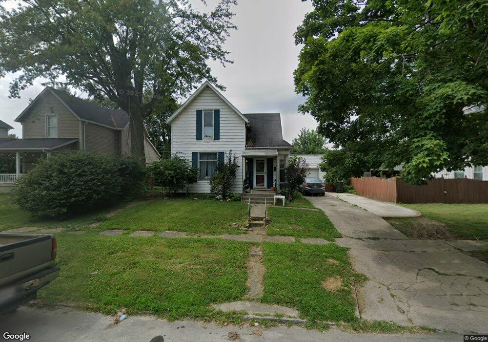
745 N Main St Kenton, OH 43326
Estimated Value: $129,473 - $168,000
3
Beds
2
Baths
1,529
Sq Ft
$96/Sq Ft
Est. Value
About This Home
This home is located at 745 N Main St, Kenton, OH 43326 and is currently estimated at $146,368, approximately $95 per square foot. 745 N Main St is a home located in Hardin County with nearby schools including Kenton Elementary School, Kenton Middle School, and Kenton High School.
Ownership History
Date
Name
Owned For
Owner Type
Purchase Details
Closed on
Jun 23, 2022
Sold by
Cassandra Evans
Bought by
Mullett Derek T
Current Estimated Value
Home Financials for this Owner
Home Financials are based on the most recent Mortgage that was taken out on this home.
Original Mortgage
$121,212
Outstanding Balance
$115,364
Interest Rate
5.3%
Mortgage Type
Balloon
Estimated Equity
$31,004
Purchase Details
Closed on
Sep 7, 2011
Sold by
Headings David L and Headings Susan M
Bought by
Evans Cassandra
Home Financials for this Owner
Home Financials are based on the most recent Mortgage that was taken out on this home.
Original Mortgage
$81,347
Interest Rate
4.59%
Mortgage Type
New Conventional
Purchase Details
Closed on
Jul 31, 1998
Bought by
Headings David L and Headings Susan
Purchase Details
Closed on
Aug 4, 1997
Bought by
Baker Denis M
Purchase Details
Closed on
Nov 7, 1988
Create a Home Valuation Report for This Property
The Home Valuation Report is an in-depth analysis detailing your home's value as well as a comparison with similar homes in the area
Home Values in the Area
Average Home Value in this Area
Purchase History
| Date | Buyer | Sale Price | Title Company |
|---|---|---|---|
| Mullett Derek T | $120,000 | Schwemer Mckinley Seeley And P | |
| Evans Cassandra | $78,000 | None Available | |
| Headings David L | $68,400 | -- | |
| Baker Denis M | $65,000 | -- | |
| -- | $34,000 | -- |
Source: Public Records
Mortgage History
| Date | Status | Borrower | Loan Amount |
|---|---|---|---|
| Open | Mullett Derek T | $121,212 | |
| Previous Owner | Evans Cassandra | $81,347 |
Source: Public Records
Tax History Compared to Growth
Tax History
| Year | Tax Paid | Tax Assessment Tax Assessment Total Assessment is a certain percentage of the fair market value that is determined by local assessors to be the total taxable value of land and additions on the property. | Land | Improvement |
|---|---|---|---|---|
| 2024 | $1,333 | $30,170 | $3,550 | $26,620 |
| 2023 | $1,333 | $30,170 | $3,550 | $26,620 |
| 2022 | $1,752 | $37,060 | $3,110 | $33,950 |
| 2021 | $1,759 | $37,060 | $3,110 | $33,950 |
| 2020 | $1,530 | $37,060 | $3,110 | $33,950 |
| 2019 | $1,264 | $31,500 | $2,960 | $28,540 |
| 2018 | $1,267 | $31,500 | $2,960 | $28,540 |
| 2017 | $1,246 | $31,500 | $2,960 | $28,540 |
| 2016 | $1,072 | $27,920 | $3,700 | $24,220 |
| 2015 | $1,033 | $27,920 | $3,700 | $24,220 |
| 2014 | $1,064 | $27,920 | $3,700 | $24,220 |
| 2013 | $1,173 | $29,890 | $3,700 | $26,190 |
Source: Public Records
Map
Nearby Homes
- 299 Marie Ave
- 416 E Eliza St
- 416 N Cherry St
- 0 Gilmore St
- 503 Jennings St
- 109 Lark Ln
- 777 Maydoll Dr
- 0 N Barron St
- 328 N Detroit St
- 416 Center St
- 104 Oak Ln Unit 15
- 310 N Market St
- 233 N Main St
- 700 N Ida St
- 215 N Main St
- 324 Stone Hedge Ln Unit 324
- 219 W Carrol St
- 424 W Carrol St
- 509 E Carrol St
- 368 N Ida St