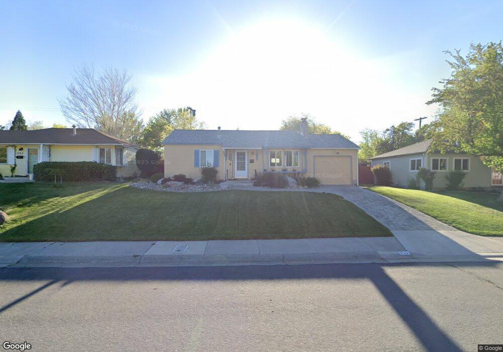
745 Reeves Ave Reno, NV 89503
Kings Row NeighborhoodEstimated Value: $350,000 - $426,000
2
Beds
1
Bath
875
Sq Ft
$455/Sq Ft
Est. Value
About This Home
This home is located at 745 Reeves Ave, Reno, NV 89503 and is currently estimated at $398,211, approximately $455 per square foot. 745 Reeves Ave is a home located in Washoe County with nearby schools including Elmcrest Elementary School, Archie Clayton Pre-AP Academy, and Robert McQueen High School.
Ownership History
Date
Name
Owned For
Owner Type
Purchase Details
Closed on
Jun 20, 2023
Sold by
Webb Cheryl M
Bought by
Cheryl M Webb Living Trust
Current Estimated Value
Purchase Details
Closed on
Aug 23, 2021
Sold by
Margaret Elmore Winifred
Bought by
Richard & Winifred Elmore Trust
Purchase Details
Closed on
Aug 17, 2021
Sold by
Elmore Brian T and Stoltz Lynne E
Bought by
Webb Cheryl
Purchase Details
Closed on
Oct 13, 2000
Sold by
Elmore Richard J
Bought by
Elmore Richard J and Elmore Winifred B
Create a Home Valuation Report for This Property
The Home Valuation Report is an in-depth analysis detailing your home's value as well as a comparison with similar homes in the area
Home Values in the Area
Average Home Value in this Area
Purchase History
| Date | Buyer | Sale Price | Title Company |
|---|---|---|---|
| Cheryl M Webb Living Trust | -- | None Listed On Document | |
| Richard & Winifred Elmore Trust | -- | -- | |
| Webb Cheryl | -- | None Available | |
| Elmore Richard J | -- | -- |
Source: Public Records
Tax History Compared to Growth
Tax History
| Year | Tax Paid | Tax Assessment Tax Assessment Total Assessment is a certain percentage of the fair market value that is determined by local assessors to be the total taxable value of land and additions on the property. | Land | Improvement |
|---|---|---|---|---|
| 2025 | $724 | $53,757 | $39,795 | $13,962 |
| 2024 | $724 | $51,245 | $37,485 | $13,760 |
| 2023 | $704 | $51,926 | $39,200 | $12,726 |
| 2022 | $683 | $41,878 | $31,500 | $10,378 |
| 2021 | $664 | $31,353 | $21,245 | $10,108 |
| 2020 | $643 | $29,905 | $19,985 | $9,920 |
| 2019 | $624 | $29,688 | $20,300 | $9,388 |
| 2018 | $596 | $23,460 | $14,455 | $9,005 |
| 2017 | $572 | $21,767 | $12,915 | $8,852 |
| 2016 | $557 | $20,175 | $11,340 | $8,835 |
| 2015 | $144 | $18,322 | $9,625 | $8,697 |
| 2014 | $541 | $16,822 | $8,575 | $8,247 |
| 2013 | -- | $14,190 | $6,125 | $8,065 |
Source: Public Records
Map
Nearby Homes
- 895 Stoker Ave
- 1801 Carlin St
- 880 Ruby Ave
- 1970 W 6th St
- 1785 Stardust St
- 2100 W 6th St
- 1670 Majestic Dr
- 1600 Majestic Dr
- 2260 W 6th St
- 1510 Majestic Dr Unit one
- 90/100 Arden Cir
- 1415 Kings Row
- 1375 Wesley Dr
- 1540 King Edward Dr
- 2595 W 7th St
- 1217 Keystone Ave
- 2091 W 4th St
- 2718 Powder Dr
- 1765 Harold Dr
- 610 Akard Cir