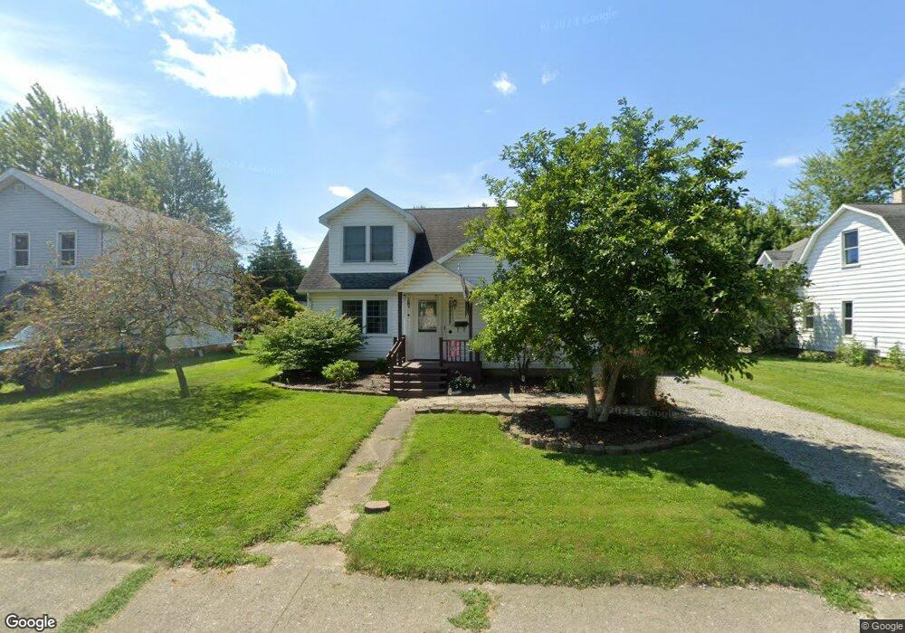
749 Welsted St Napoleon, OH 43545
Estimated Value: $161,000 - $195,000
4
Beds
1
Bath
1,300
Sq Ft
$134/Sq Ft
Est. Value
About This Home
This home is located at 749 Welsted St, Napoleon, OH 43545 and is currently estimated at $174,054, approximately $133 per square foot. 749 Welsted St is a home located in Henry County with nearby schools including Napoleon Elementary School, Napoleon Junior/Senior High School, and St. Paul Lutheran School.
Ownership History
Date
Name
Owned For
Owner Type
Purchase Details
Closed on
May 14, 2004
Sold by
Maassel Patricia L
Bought by
Bensman John C and Bensman Janice E
Current Estimated Value
Home Financials for this Owner
Home Financials are based on the most recent Mortgage that was taken out on this home.
Original Mortgage
$72,000
Interest Rate
5.75%
Mortgage Type
Unknown
Purchase Details
Closed on
Jul 17, 2001
Sold by
Buckmaster Stephen J
Bought by
Maassel Patricia L
Create a Home Valuation Report for This Property
The Home Valuation Report is an in-depth analysis detailing your home's value as well as a comparison with similar homes in the area
Home Values in the Area
Average Home Value in this Area
Purchase History
| Date | Buyer | Sale Price | Title Company |
|---|---|---|---|
| Bensman John C | $90,000 | Vintage Land Title | |
| Maassel Patricia L | $97,000 | -- |
Source: Public Records
Mortgage History
| Date | Status | Borrower | Loan Amount |
|---|---|---|---|
| Previous Owner | Bensman John C | $72,000 | |
| Closed | Maassel Patricia L | -- |
Source: Public Records
Tax History Compared to Growth
Tax History
| Year | Tax Paid | Tax Assessment Tax Assessment Total Assessment is a certain percentage of the fair market value that is determined by local assessors to be the total taxable value of land and additions on the property. | Land | Improvement |
|---|---|---|---|---|
| 2024 | $1,965 | $46,430 | $7,810 | $38,620 |
| 2023 | $1,965 | $47,260 | $7,810 | $39,450 |
| 2022 | $1,444 | $63,000 | $13,280 | $49,720 |
| 2021 | $1,444 | $31,500 | $6,640 | $24,860 |
| 2020 | $1,573 | $33,420 | $6,640 | $26,780 |
| 2019 | $1,321 | $27,210 | $5,820 | $21,390 |
| 2018 | $1,289 | $27,210 | $5,820 | $21,390 |
| 2017 | $1,240 | $27,210 | $5,820 | $21,390 |
| 2016 | $1,209 | $25,750 | $5,820 | $19,930 |
| 2015 | $1,188 | $25,750 | $5,820 | $19,930 |
| 2014 | $1,336 | $25,750 | $5,820 | $19,930 |
| 2013 | $1,336 | $27,020 | $5,820 | $21,200 |
Source: Public Records
Map
Nearby Homes
- 900 Welsted St
- 725 Sheffield Ave
- 551 W Main St
- 825 Old School Dr
- 513 W Washington St
- 432 W Clinton St
- 342 W Clinton St
- 1354 Clairmont Ave
- 1050 Indiana Ave
- 1122 Ohio St
- 1109 Highland Ave
- 1214 Clairmont Ave
- 1124 Highland Ave
- 1081 Scott St
- 1309 Lagrange St
- 1314 Clairmont Ave
- 1113 Clairmont Ave
- 948 Dagget Dr
- 701 S Perry St
- 0 Westmoreland Ave
- 755 Welsted St
- 743 Welsted St
- 737 Welsted St
- 748 Strong St
- 744 Strong St
- 410 Sheffield Ave
- 742 Strong St
- 750 Welsted St
- 729 Welsted St
- 419 Sheffield Ave
- 758 Welsted St
- 744 Welsted St
- 415 Sheffield Ave
- 736 Welsted St
- 730 Strong St
- 401 Sheffield Ave
- 723 Welsted St
- 732 Welsted St
- 728 Welsted St
- 620 Sheffield Ave