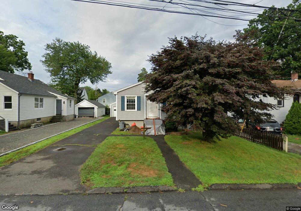
75 May St Fairfield, CT 06825
Tunxis Hill NeighborhoodEstimated Value: $380,000 - $500,000
3
Beds
2
Baths
1,129
Sq Ft
$403/Sq Ft
Est. Value
About This Home
This home is located at 75 May St, Fairfield, CT 06825 and is currently estimated at $454,905, approximately $402 per square foot. 75 May St is a home located in Fairfield County with nearby schools including Mckinley Elementary School, Tomlinson Middle School, and Fairfield Warde High School.
Ownership History
Date
Name
Owned For
Owner Type
Purchase Details
Closed on
Jun 3, 2024
Sold by
Damico Salvatore E Est and Turgeon
Bought by
Damico Stephen M and Damico Ratikarn
Current Estimated Value
Purchase Details
Closed on
Mar 14, 2014
Sold by
Turgeon Sally
Bought by
Damico Salvatore
Purchase Details
Closed on
Mar 6, 2014
Sold by
Damico Salvatore
Bought by
Damico Salvatore
Create a Home Valuation Report for This Property
The Home Valuation Report is an in-depth analysis detailing your home's value as well as a comparison with similar homes in the area
Home Values in the Area
Average Home Value in this Area
Purchase History
| Date | Buyer | Sale Price | Title Company |
|---|---|---|---|
| Damico Stephen M | $375,000 | None Available | |
| Damico Stephen M | $375,000 | None Available | |
| Damico Stephen M | $375,000 | None Available | |
| Damico Salvatore | -- | -- | |
| Damico Salvatore | -- | -- | |
| Damico Salvatore | -- | -- | |
| Damico Salvatore | -- | -- |
Source: Public Records
Mortgage History
| Date | Status | Borrower | Loan Amount |
|---|---|---|---|
| Previous Owner | Damico Salvatore | $420,000 |
Source: Public Records
Tax History
| Year | Tax Paid | Tax Assessment Tax Assessment Total Assessment is a certain percentage of the fair market value that is determined by local assessors to be the total taxable value of land and additions on the property. | Land | Improvement |
|---|---|---|---|---|
| 2025 | $6,163 | $217,070 | $167,580 | $49,490 |
| 2024 | $6,056 | $217,070 | $167,580 | $49,490 |
| 2023 | $5,972 | $217,070 | $167,580 | $49,490 |
| 2022 | $5,913 | $217,070 | $167,580 | $49,490 |
| 2021 | $5,857 | $217,070 | $167,580 | $49,490 |
| 2020 | $5,101 | $190,400 | $139,650 | $50,750 |
| 2019 | $5,101 | $190,400 | $139,650 | $50,750 |
| 2018 | $5,019 | $190,400 | $139,650 | $50,750 |
| 2017 | $4,916 | $190,400 | $139,650 | $50,750 |
| 2016 | $4,846 | $190,400 | $139,650 | $50,750 |
| 2015 | $4,904 | $197,820 | $148,120 | $49,700 |
| 2014 | $4,827 | $197,820 | $148,120 | $49,700 |
Source: Public Records
Map
Nearby Homes
- 45 Sterling St
- 51 Sterling St
- 53 Sterling St
- 47 Sterling St
- 198 Castle Ave
- 206 Sterling St
- 37 Biro St
- 187 Halley Ave
- 145 Brentwood Ave
- 156 Halley Ave
- 130 Brentwood Ave
- 57 Hibiscus St Unit 1
- 118 Berwick Ave
- 1 Overlook Ave
- 652 Black Rock Turnpike
- 65 Benton St
- 1335 Black Rock Turnpike
- 143 Sawyer Rd
- 21 Boroskey Rd
- 240 Sunnyridge Ave Unit 63
Your Personal Tour Guide
Ask me questions while you tour the home.