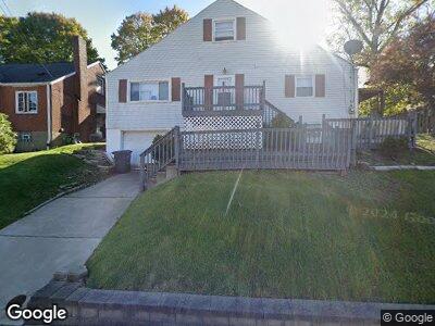
752 7th St Trafford, PA 15085
Trafford NeighborhoodEstimated Value: $59,000 - $194,000
--
Bed
--
Bath
--
Sq Ft
5,968
Sq Ft Lot
About This Home
This home is located at 752 7th St, Trafford, PA 15085 and is currently estimated at $137,667. 752 7th St is a home located in Westmoreland County with nearby schools including Penn Trafford High School.
Ownership History
Date
Name
Owned For
Owner Type
Purchase Details
Closed on
May 3, 2011
Sold by
Us Bank National Association
Bought by
S & T Enterprise Inc
Current Estimated Value
Purchase Details
Closed on
Dec 2, 2010
Sold by
Haberstroh Kevin C and Davis Leigh Ann
Bought by
Us Bank National Association
Create a Home Valuation Report for This Property
The Home Valuation Report is an in-depth analysis detailing your home's value as well as a comparison with similar homes in the area
Home Values in the Area
Average Home Value in this Area
Purchase History
| Date | Buyer | Sale Price | Title Company |
|---|---|---|---|
| S & T Enterprise Inc | $20,000 | None Available | |
| Us Bank National Association | $1,185 | None Available |
Source: Public Records
Mortgage History
| Date | Status | Borrower | Loan Amount |
|---|---|---|---|
| Open | S & T Enterprise Inc | $900,000 | |
| Closed | S & T Enterprises Inc | $85,000 | |
| Closed | S&T Enterprise Inc | $48,000 | |
| Previous Owner | Haberstrroh Kevin C | $19,382 |
Source: Public Records
Tax History Compared to Growth
Tax History
| Year | Tax Paid | Tax Assessment Tax Assessment Total Assessment is a certain percentage of the fair market value that is determined by local assessors to be the total taxable value of land and additions on the property. | Land | Improvement |
|---|---|---|---|---|
| 2025 | $1,533 | $10,170 | $2,730 | $7,440 |
| 2024 | $1,523 | $10,170 | $2,730 | $7,440 |
| 2023 | $1,452 | $10,170 | $2,730 | $7,440 |
| 2022 | $1,436 | $10,170 | $2,730 | $7,440 |
| 2021 | $1,426 | $10,170 | $2,730 | $7,440 |
| 2020 | $1,416 | $10,170 | $2,730 | $7,440 |
| 2019 | $1,386 | $10,170 | $2,730 | $7,440 |
| 2018 | $1,370 | $10,170 | $2,730 | $7,440 |
| 2017 | $1,350 | $10,170 | $2,730 | $7,440 |
| 2016 | $1,315 | $10,170 | $2,730 | $7,440 |
| 2015 | $1,285 | $10,170 | $2,730 | $7,440 |
| 2014 | $1,265 | $10,170 | $2,730 | $7,440 |
Source: Public Records
Map
Nearby Homes
- 841 8th St
- 1804 Forbes Rd
- 735 5th St
- 509 Duquesne Ave
- 438 Cavitt Ave
- 601 Brinton Ave
- 321 3rd St
- 15013 Murrysville Rd
- 204 2nd St
- 179 Kelvington Dr
- . Old Ramsey Rd
- 129 Regal Ct
- 173 Penn Lear Dr
- 109 Regal Ct
- 4390 Brickner St
- 2096 Ramsey Rd
- #15 Mosside Blvd
- 143 Bradford Square Dr
- 113 Saunders Station Rd
- 642 Irwin St