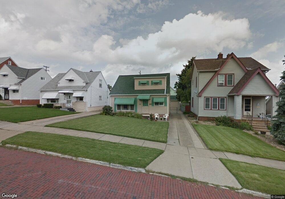
7522 Liberty Ave Cleveland, OH 44129
Estimated Value: $170,000 - $178,000
3
Beds
1
Bath
1,092
Sq Ft
$159/Sq Ft
Est. Value
About This Home
This home is located at 7522 Liberty Ave, Cleveland, OH 44129 and is currently estimated at $173,791, approximately $159 per square foot. 7522 Liberty Ave is a home located in Cuyahoga County with nearby schools including Ridge-Brook Elementary School, Greenbriar Middle School, and Parma High School.
Ownership History
Date
Name
Owned For
Owner Type
Purchase Details
Closed on
Jul 15, 1991
Sold by
Dillon Robert K
Bought by
Mulhall Christopher C
Current Estimated Value
Purchase Details
Closed on
Sep 15, 1986
Sold by
Tenik Joseph N
Bought by
Dillon Robert K
Purchase Details
Closed on
Apr 20, 1978
Sold by
Abraham Carol A
Bought by
Tenik Joseph N
Purchase Details
Closed on
Jul 10, 1975
Sold by
Abraham Jerrett M and Abraham Carol A
Bought by
Abraham Carol A
Purchase Details
Closed on
Jan 1, 1975
Bought by
Abraham Jerrett M and Abraham Carol A
Create a Home Valuation Report for This Property
The Home Valuation Report is an in-depth analysis detailing your home's value as well as a comparison with similar homes in the area
Home Values in the Area
Average Home Value in this Area
Purchase History
| Date | Buyer | Sale Price | Title Company |
|---|---|---|---|
| Mulhall Christopher C | -- | -- | |
| Dillon Robert K | $53,700 | -- | |
| Tenik Joseph N | $40,000 | -- | |
| Abraham Carol A | -- | -- | |
| Abraham Jerrett M | -- | -- |
Source: Public Records
Tax History Compared to Growth
Tax History
| Year | Tax Paid | Tax Assessment Tax Assessment Total Assessment is a certain percentage of the fair market value that is determined by local assessors to be the total taxable value of land and additions on the property. | Land | Improvement |
|---|---|---|---|---|
| 2024 | $2,393 | $47,180 | $9,730 | $37,450 |
| 2023 | $1,934 | $34,660 | $8,020 | $26,640 |
| 2022 | $1,939 | $34,650 | $8,020 | $26,640 |
| 2021 | $1,990 | $34,650 | $8,020 | $26,640 |
| 2020 | $1,605 | $26,640 | $6,160 | $20,480 |
| 2019 | $1,510 | $76,100 | $17,600 | $58,500 |
| 2018 | $1,351 | $26,640 | $6,160 | $20,480 |
| 2017 | $1,323 | $22,960 | $4,340 | $18,620 |
| 2016 | $1,316 | $22,960 | $4,340 | $18,620 |
| 2015 | $1,290 | $22,960 | $4,340 | $18,620 |
| 2014 | $1,290 | $24,430 | $4,620 | $19,810 |
Source: Public Records
Map
Nearby Homes
- 7707 Liberty Ave
- 8206 Newport Ave
- 6606 Theota Ave
- 6211 Luelda Ave
- 6508 Delora Ave
- 8018 Pinegrove Ave
- 6014 Laverne Ave
- 6306 Flowerdale Ave
- 5906 Velma Ave
- 8119 Pinegrove Ave
- 5810 Laverne Ave
- 6209 Archmere Ave
- 6011 Theota Ave
- 6025 Northcliff Ave
- 5901 Delora Ave
- 7609 Wooster Pkwy
- 5618 Bradley Ave
- 5637 Flowerdale Ave
- 4739 Ridge Rd
- 5511 Velma Ave
- 7518 Liberty Ave
- 7602 Liberty Ave
- 7514 Liberty Ave
- 7606 Liberty Ave
- 7523 Brookpark Rd
- 7510 Liberty Ave
- 7610 Liberty Ave
- 7517 Brookpark Rd Unit up
- 7517 Brookpark Rd
- 7614 Liberty Ave
- 7506 Liberty Ave
- 7523 Liberty Ave
- 7519 Liberty Ave
- 7603 Liberty Ave
- 7607 Liberty Ave
- 7515 Liberty Ave
- 7618 Liberty Ave
- 7502 Liberty Ave
- 7511 Liberty Ave
- 7507 Liberty Ave