Estimated Value: $226,000 - $249,000
3
Beds
2
Baths
1,288
Sq Ft
$184/Sq Ft
Est. Value
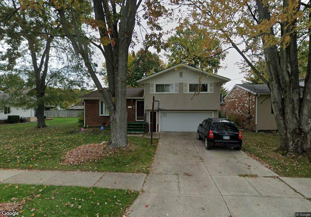
About This Home
This home is located at 755 Edwards Dr, Berea, OH 44017 and is currently estimated at $237,507, approximately $184 per square foot. 755 Edwards Dr is a home located in Cuyahoga County with nearby schools including Grindstone Elementary School, Berea-Midpark Middle School, and Berea-Midpark High School.
Ownership History
Date
Name
Owned For
Owner Type
Purchase Details
Closed on
Aug 28, 1995
Sold by
Oriold Charles A
Bought by
Smith Joyce J
Current Estimated Value
Home Financials for this Owner
Home Financials are based on the most recent Mortgage that was taken out on this home.
Original Mortgage
$103,323
Interest Rate
7.43%
Mortgage Type
FHA
Purchase Details
Closed on
Oct 23, 1986
Sold by
Good Paul E and Good Claire E
Bought by
Oriold Charles A
Purchase Details
Closed on
Oct 27, 1981
Sold by
Stockstad Rodney W
Bought by
Good Paul E and Good Claire E
Purchase Details
Closed on
Mar 10, 1977
Sold by
Witt David A and Mary Jane
Bought by
Stockstad Rodney W
Purchase Details
Closed on
Jan 1, 1975
Bought by
Witt David A and Mary Jane
Create a Home Valuation Report for This Property
The Home Valuation Report is an in-depth analysis detailing your home's value as well as a comparison with similar homes in the area
Home Values in the Area
Average Home Value in this Area
Purchase History
| Date | Buyer | Sale Price | Title Company |
|---|---|---|---|
| Smith Joyce J | $103,500 | -- | |
| Oriold Charles A | $69,500 | -- | |
| Good Paul E | $66,000 | -- | |
| Stockstad Rodney W | $49,900 | -- | |
| Witt David A | -- | -- |
Source: Public Records
Mortgage History
| Date | Status | Borrower | Loan Amount |
|---|---|---|---|
| Closed | Smith Joyce J | $103,323 |
Source: Public Records
Tax History
| Year | Tax Paid | Tax Assessment Tax Assessment Total Assessment is a certain percentage of the fair market value that is determined by local assessors to be the total taxable value of land and additions on the property. | Land | Improvement |
|---|---|---|---|---|
| 2024 | $4,462 | $68,775 | $8,750 | $60,025 |
| 2023 | $4,468 | $56,350 | $8,680 | $47,670 |
| 2022 | $4,627 | $56,350 | $8,680 | $47,670 |
| 2021 | $5,080 | $56,350 | $8,680 | $47,670 |
| 2020 | $3,662 | $47,740 | $7,350 | $40,390 |
| 2019 | $3,800 | $136,400 | $21,000 | $115,400 |
| 2018 | $4,096 | $47,740 | $7,350 | $40,390 |
| 2017 | $3,567 | $38,090 | $5,990 | $32,100 |
| 2016 | $3,597 | $38,090 | $5,990 | $32,100 |
| 2015 | $3,571 | $38,090 | $5,990 | $32,100 |
| 2014 | $3,571 | $40,080 | $6,300 | $33,780 |
Source: Public Records
Map
Nearby Homes
- 9003 Prospect Rd
- 8036 Fair Rd
- 21032 Breckenridge Ln
- 10020 Fair Rd
- 275 Quarrystone Ln
- 8902 Lincolnshire Blvd
- 49 Monroe St
- 516 Fair St
- 20456 Scotch Pine Way
- 458 Sprague Rd
- 19890 Idlewood Trail
- 21586 Little Brook Way
- 20050 Idlewood Trail
- 647 Tampico Ct Unit 7
- 23004 Chandlers Ln Unit 4-344
- 9384 N Marks Rd
- 18433 Whitney Rd
- 388 Fairwood Cir
- 57 Riverside Dr
- 23002 Chandlers Ln
Your Personal Tour Guide
Ask me questions while you tour the home.