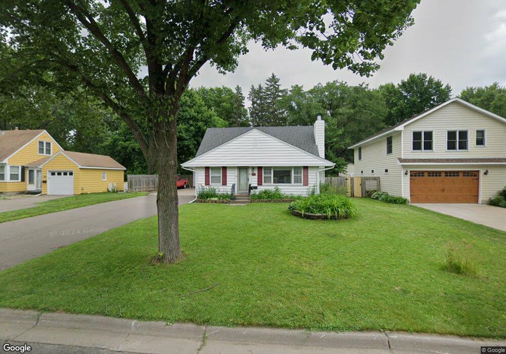
756 Ashland Ave Saint Paul Park, MN 55071
Estimated Value: $307,000 - $330,869
3
Beds
2
Baths
1,085
Sq Ft
$291/Sq Ft
Est. Value
About This Home
This home is located at 756 Ashland Ave, Saint Paul Park, MN 55071 and is currently estimated at $315,717, approximately $290 per square foot. 756 Ashland Ave is a home located in Washington County with nearby schools including Pullman Elementary School, Oltman Middle School, and Park Senior High School.
Ownership History
Date
Name
Owned For
Owner Type
Purchase Details
Closed on
Mar 14, 2022
Sold by
Magnan Darren and Magnan Elizabeth
Bought by
Sanders Kevin and Knapp Kelly
Current Estimated Value
Home Financials for this Owner
Home Financials are based on the most recent Mortgage that was taken out on this home.
Original Mortgage
$252,000
Outstanding Balance
$235,449
Interest Rate
3.92%
Mortgage Type
New Conventional
Estimated Equity
$80,268
Purchase Details
Closed on
Mar 7, 2022
Sold by
Magnan and Elizabeth
Bought by
Sanders Kevin Thomas and Knapp Kelly Dean
Home Financials for this Owner
Home Financials are based on the most recent Mortgage that was taken out on this home.
Original Mortgage
$252,000
Outstanding Balance
$235,449
Interest Rate
3.92%
Mortgage Type
New Conventional
Estimated Equity
$80,268
Purchase Details
Closed on
Jan 23, 2020
Sold by
Magnan Darren Allen and Magnan Elizabeth
Bought by
Magnan Darren and Magnan Elizabeth
Home Financials for this Owner
Home Financials are based on the most recent Mortgage that was taken out on this home.
Original Mortgage
$203,400
Interest Rate
3.6%
Mortgage Type
New Conventional
Purchase Details
Closed on
Jan 9, 2020
Sold by
Fleifel Chris and Oswald Madeline
Bought by
Magnan Darren Allen
Home Financials for this Owner
Home Financials are based on the most recent Mortgage that was taken out on this home.
Original Mortgage
$203,400
Interest Rate
3.6%
Mortgage Type
New Conventional
Purchase Details
Closed on
Feb 14, 2018
Sold by
Tucci William W and Tucci Ingrid
Bought by
Fleifel Chris and Oswald Madeline
Home Financials for this Owner
Home Financials are based on the most recent Mortgage that was taken out on this home.
Original Mortgage
$189,150
Interest Rate
3.99%
Mortgage Type
New Conventional
Purchase Details
Closed on
Oct 19, 2001
Sold by
Schweigert Kathryn M
Bought by
Tucci William W
Purchase Details
Closed on
Dec 17, 1999
Sold by
Machy Michael C and Larson Marie E
Bought by
Schweigert Kathryn M
Purchase Details
Closed on
Dec 31, 1998
Sold by
Hartnett Josephine J
Bought by
Marty Michael C and Larson Marie E
Create a Home Valuation Report for This Property
The Home Valuation Report is an in-depth analysis detailing your home's value as well as a comparison with similar homes in the area
Home Values in the Area
Average Home Value in this Area
Purchase History
| Date | Buyer | Sale Price | Title Company |
|---|---|---|---|
| Sanders Kevin | $335,000 | -- | |
| Sanders Kevin Thomas | $335,000 | None Listed On Document | |
| Magnan Darren | -- | None Available | |
| Magnan Darren Allen | $226,000 | Edgewater Title Group Llc | |
| Fleifel Chris | $195,000 | Title Recording Services Inc | |
| Tucci William W | $147,977 | -- | |
| Schweigert Kathryn M | $120,000 | -- | |
| Marty Michael C | $97,500 | -- |
Source: Public Records
Mortgage History
| Date | Status | Borrower | Loan Amount |
|---|---|---|---|
| Open | Sanders Kevin | $252,000 | |
| Closed | Sanders Kevin Thomas | $252,000 | |
| Previous Owner | Magnan Darren Allen | $203,400 | |
| Previous Owner | Fleifel Chris | $189,150 |
Source: Public Records
Tax History Compared to Growth
Tax History
| Year | Tax Paid | Tax Assessment Tax Assessment Total Assessment is a certain percentage of the fair market value that is determined by local assessors to be the total taxable value of land and additions on the property. | Land | Improvement |
|---|---|---|---|---|
| 2024 | $3,688 | $291,400 | $80,000 | $211,400 |
| 2023 | $3,688 | $293,600 | $92,000 | $201,600 |
| 2022 | $2,942 | $264,900 | $91,300 | $173,600 |
| 2021 | $2,802 | $220,700 | $76,000 | $144,700 |
| 2020 | $2,670 | $214,400 | $76,000 | $138,400 |
| 2019 | $2,646 | $202,800 | $67,000 | $135,800 |
| 2018 | $2,340 | $190,400 | $63,000 | $127,400 |
| 2017 | $2,166 | $161,400 | $54,000 | $107,400 |
| 2016 | $2,200 | $153,300 | $49,000 | $104,300 |
| 2015 | $2,064 | $130,700 | $47,500 | $83,200 |
| 2013 | -- | $107,700 | $37,600 | $70,100 |
Source: Public Records
Map
Nearby Homes
- 801 Summit Ave
- 1033 Portland Ave
- TBD Broadway Ave
- 1200 Summit Ave
- 6444 Genevieve Trail
- 6538 Genevieve Trail
- 1637 Pullman Ave
- 6745 Wildflower Dr S
- 11XX 1st St
- 6283 Highland Hills Ln S
- 6291 Highland Hills Ln S
- 6266 Highland Hills Ln S
- 6295 Highland Hills Ln S
- 6284 Highland Hills Ln S
- 6290 Highland Hills Ln S
- 1142 1st St
- 6296 Highland Hills Ln S
- 1601 14th Ave
- 6219 64th St S
- 6300 Highland Hills Ln S
- 742 Ashland Ave
- 770 Ashland Ave
- 701 Hastings Ave
- 784 Ashland Ave
- 785 785 Ashland Ave
- 757 Ashland Ave
- 798 Ashland Ave
- 743 Ashland Ave
- 715 715 Ashland-Avenue-
- 1011 8th Ave
- 729 Ashland Ave
- 785 Ashland Ave
- 715 Ashland Ave
- 799 799 Ashland Ave
- 700 Hastings Ave
- 1004 1004 8th Ave
- 715 Ashland Ave
- 799 Ashland Ave
- 701 Ashland Ave
- 705 Hastings Ave