NOT LISTED FOR SALE

7574 Ms Highway 569 N Smithdale, MS 39664

Estimated Value: $172,000 - $601,000

210 Acres
$1,661 Price per Acre
9,160,668 Sq Ft Lot

Last Sold May 31, 2023

Current estimated payment $2,016/month

357 Days on Market

Highlights

  • Home fronts a pond
  • Wooded Lot
  • Pasture
  • 210.3 Acre Lot

About This Lot

As of May 2023

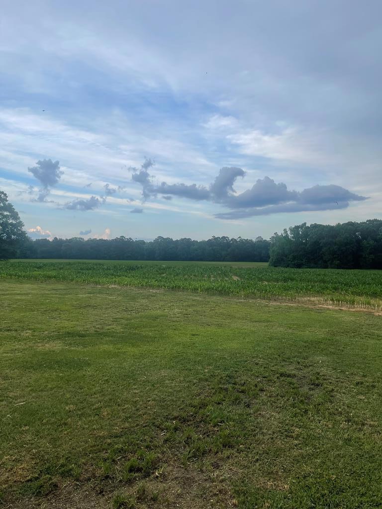
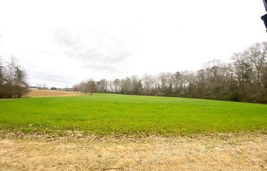
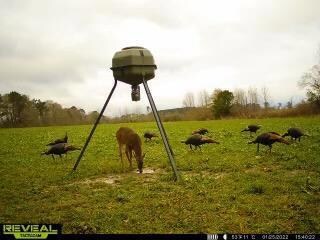
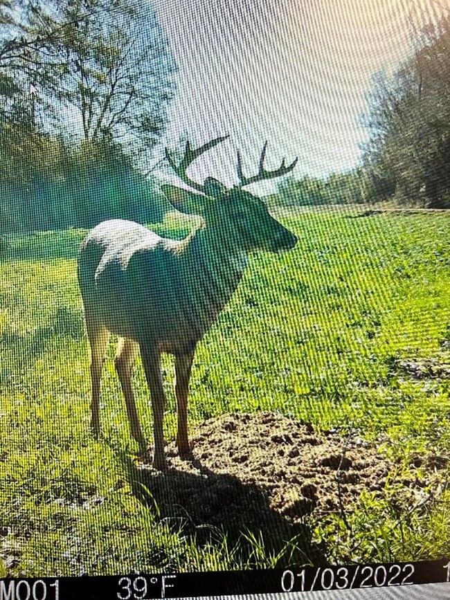
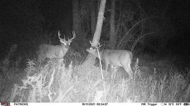
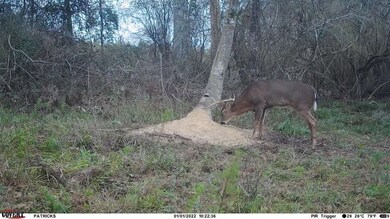
Look no further for some of the best hunting property in the area. This 210 acre tract offers everything a sportsman could ever want. Whitetail deer in the 120 to 140 class taken in the area yearly. There are 15 acres of food plots and box stands on them. There is 40 acres of mature hardwoods and pines timber and the rest of the property is currently being row cropped in corn. The turkey population is abundant on this property. There is a 4.5 acre pond for the fisherman. There is a home site on the front of the property with a electricity, well, and a house slab that could easily become a hunting camp or a home. This is certainly a must see property! Please contact listing agent for a showing of the wonderful property.

Last Listed By

Chris Smith

Black Hawk Real Estate License #S-55105 Listed on: 04/30/2022

Property Details

Property Type

  • Land

Est. Annual Taxes

  • $1,995

Year Built

  • 1982

Lot Details

  • 210.3 Acre Lot
  • Home fronts a pond
  • Sloped Lot
  • Wooded Lot
  • Many Trees

Farming

  • Pasture

Utilities

  • Natural Gas Not Available
  • Well
  • Sewer Not Available

Listing and Financial Details

  • Assessor Parcel Number 46 300080000500

Property Details

Property Type

Land

Est. Annual Taxes

$1,995

Year Built

1982

Lot Details

0

Listing Details

  • Directions: From Summit, MS. take Hwy 98 west __8_miles. Turn left onto Hwy 569 south go __2__miles turn left onto Carl Wilson lane, property will begin on left.( 31.3314459, -90.6341067)
  • Prop. Type: Land
  • Property Sub Type: Unimproved Land
  • Lot Size Acres: 210.3
  • Lot Size: 210 +/-
  • Road Surface Type: Gravel, Paved
  • Subdivision Name: None
  • Special Features: None
  • Year Built (Public Record): 1982

Exterior Features

  • Lot Features: Sloped, Many Trees, Pasture, Wooded
  • Waterfront Features: Pond, Waterfront
  • Waterfront: Yes

Utilities

  • Sewer: None
  • Electric: Magnolia EPA
  • Electricity On Property: Yes
  • Utilities: Electricity Connected
  • Water Source: Well
  • Gas Company: None

Schools

  • Junior High Dist: Liberty/Amite

Lot Info

  • Parcel #: 46 300080000500
  • Current Use: Timber, Fishing, Farm, Hunting, Pasture
  • Lot Size Sq Ft: 9160668
  • Farm Land Area Units: Square Feet
  • Zoning Description: None
  • ResoLotSizeUnits: Acres

Tax Info

  • Tax Annual Amount: 1995.17
  • Tax Map Number: 46 3007 0

Range of Values:

Collateral Analytics

Collateral Analytics Collateral Analytics AVMs (Automated Valuation Model) employ a number of statistical approaches combined with neighborhood-specific comparable selection guarantees the most up-to-date and precise valuations.

Not Available

Collateral Analytics does not have data for the current month. Please view the chart for historical values.

ICE

ICE Mortgage Technology ICE Mortgage Technology’s AVM (Automated Valuation Model) is a state-of-the-art online residential property valuation tool that provides a quick and accurate estimate of the value of almost any home in the U.S.

Not Available

ICE Mortgage Technology does not have data for the current month. Please view the chart for historical values.

First American

First American First American Data & Analytics’ next-generation AVM combines unrivaled data assets with a blended ensemble of valuation models to produce highly accurate, reliable valuations you can trust.

Not Available

First American does not have data for the current month. Please view the chart for historical values.

Quantarium

Quantarium Quantarium’s valuation service, repeatedly proven the industry’s most accurate and comprehensive, is supercharged with a self-learning and auto-tuning AI engine that continually becomes smarter and more accurate as it processes daily inputs from the industry’s leading RE data lake.

Not Available

Quantarium does not have data for the current month. Please view the chart for historical values.

Average Value
Not Available
List Price
Sold Price
Create a Home Valuation Report for This Property
The Home Valuation Report is an in-depth analysis detailing your home's value as well as a comparison with similar homes in the area

Home Values in the Area

Source: Public Records

Average Home Value in this Area


Source: Public Records

Property History

Date Event Price Change Sq Ft Price
05/31/2023 05/31/23 Sold -- -- --
04/25/2023 04/25/23 Pending -- -- --
05/02/2022 05/02/22 For Sale $745,000 -- --
Source: Southwest Mississippi Board of REALTORS®

Tax History Compared to Growth

Source: Public Records

Tax History

Year Tax Paid Tax Assessment Tax Assessment Total Assessment is a certain percentage of the fair market value that is determined by local assessors to be the total taxable value of land and additions on the property. Land Improvement
2024 $956 $18,002 $0 $0
2023 $932 $17,962 $0 $0
2022 $890 $17,983 $0 $0
2021 $901 $18,428 $0 $0
Source: Public Records

Agents Affiliated with this Home

  • Section Image
See All Agents

Map

Source: Southwest Mississippi Board of REALTORS®

MLS Number: 136275

Southwest Mississippi Board of REALTORS®

APN: 46 30008 0000500