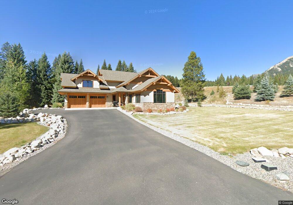
76 Brownstone Big Sky, MT 59716
Estimated Value: $2,248,281 - $2,974,000
4
Beds
4
Baths
2,828
Sq Ft
$944/Sq Ft
Est. Value
About This Home
This home is located at 76 Brownstone, Big Sky, MT 59716 and is currently estimated at $2,668,570, approximately $943 per square foot. 76 Brownstone is a home located in Gallatin County with nearby schools including Ophir Elementary School, Ophir Junior High School, and Lone Peak High School.
Ownership History
Date
Name
Owned For
Owner Type
Purchase Details
Closed on
Oct 9, 2023
Sold by
Steven P Pachel Revocable Living Trust and Heidi S Pachel Revocable Living Trust
Bought by
Stein Properties Llc
Current Estimated Value
Purchase Details
Closed on
Aug 24, 2020
Sold by
Brownstone Development Llp
Bought by
Pachel Steven P and Pachel Heidi S
Home Financials for this Owner
Home Financials are based on the most recent Mortgage that was taken out on this home.
Original Mortgage
$850,000
Interest Rate
3%
Mortgage Type
Credit Line Revolving
Create a Home Valuation Report for This Property
The Home Valuation Report is an in-depth analysis detailing your home's value as well as a comparison with similar homes in the area
Home Values in the Area
Average Home Value in this Area
Purchase History
| Date | Buyer | Sale Price | Title Company |
|---|---|---|---|
| Stein Properties Llc | -- | None Listed On Document | |
| Pachel Steven P | -- | American Land Title Company |
Source: Public Records
Mortgage History
| Date | Status | Borrower | Loan Amount |
|---|---|---|---|
| Previous Owner | Pachel Steven P | $850,000 |
Source: Public Records
Tax History
| Year | Tax Paid | Tax Assessment Tax Assessment Total Assessment is a certain percentage of the fair market value that is determined by local assessors to be the total taxable value of land and additions on the property. | Land | Improvement |
|---|---|---|---|---|
| 2025 | $15,625 | $2,979,900 | $0 | $0 |
| 2024 | $9,478 | $1,999,300 | $0 | $0 |
| 2023 | $9,129 | $2,050,000 | $0 | $0 |
| 2022 | $8,807 | $1,347,600 | $0 | $0 |
| 2021 | $8,635 | $1,354,600 | $0 | $0 |
Source: Public Records
Map
Nearby Homes
- TBD Little Coyote Rd
- 45 Turkey Leg Rd
- 45 Turkey Leg Rd Unit 1049
- 32 Rose Hip Unit N-3
- 372 Chief Joseph Trail
- 15 Spotted Fawn
- 2695 Curly Bear Rd
- 2555 Little Coyote Rd
- TBD Chief Joseph Trail
- 27 Antler Drop Ct
- 85 Spruce Cone Unit 10
- 458 Big Pine Dr
- 80 Aspen Leaf Dr Unit 7
- 148 Crail Creek Ct Unit 631
- 725 Sand Hill Rd
- 313 Spruce Cone Dr
- Lot 16 Upper Whitefish Dr
- Lot 20 Upper Whitefish Dr
- Lot 4 Upper Whitefish Dr
- Lot 19 Upper Whitefish Dr
- 90 Brownstone Loop
- 90 Brownstone Loop
- 112 Brownstone Loop
- 164 Bronco Rd
- 144 Brownstone Loop
- 164 Brownstone Loop
- 3225 Crow King Rd
- 3225 Crow King & Cos 1502a Tr 6 & 7
- 2885 Red Feather Ln
- 128 Moosewood Rd
- TBD Red Feather Ln
- TBD Lot 3 Moosewood Rd
- 28 Red Feather Ln
- 61 Chief Joseph Trail
- L20 Crow King Rd
- 3115 Crow King Rd
- 125 Chief Joseph Trail
- LOT 4 Moosewood Rd
- LOT 3 Moosewood Rd
- Moosewood Moosewood Rd Unit A