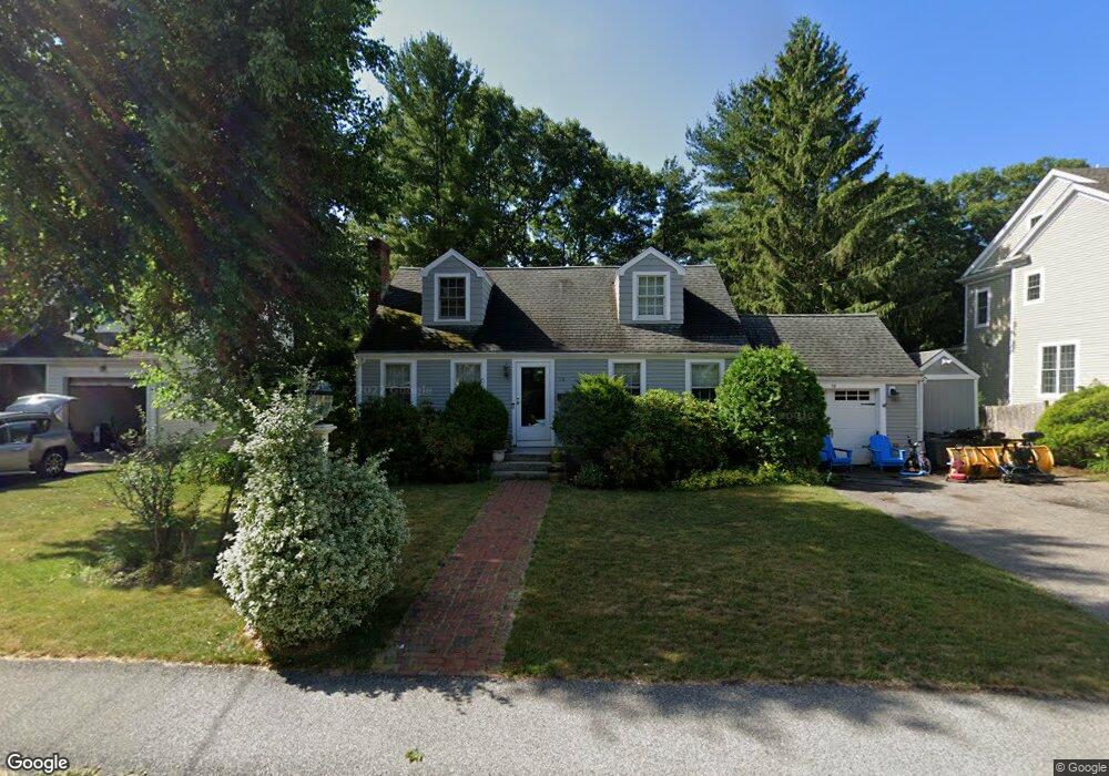
76 Grosvenor Rd Needham, MA 02492
Estimated Value: $1,244,000 - $1,408,000
4
Beds
3
Baths
2,104
Sq Ft
$643/Sq Ft
Est. Value
About This Home
This home is located at 76 Grosvenor Rd, Needham, MA 02492 and is currently estimated at $1,351,867, approximately $642 per square foot. 76 Grosvenor Rd is a home located in Norfolk County with nearby schools including Broadmeadow Elementary School, High Rock Middle School, and Pollard Middle School.
Ownership History
Date
Name
Owned For
Owner Type
Purchase Details
Closed on
May 22, 2000
Sold by
Webber Cynthia
Bought by
Hamburger Stephen
Current Estimated Value
Home Financials for this Owner
Home Financials are based on the most recent Mortgage that was taken out on this home.
Original Mortgage
$200,000
Outstanding Balance
$69,343
Interest Rate
8.19%
Mortgage Type
Purchase Money Mortgage
Estimated Equity
$1,282,524
Purchase Details
Closed on
Apr 26, 1991
Sold by
Ninomiya Yoshifumi and Ninomiya Fumiko
Bought by
Webber Cynthia
Home Financials for this Owner
Home Financials are based on the most recent Mortgage that was taken out on this home.
Original Mortgage
$152,500
Interest Rate
9.41%
Mortgage Type
Purchase Money Mortgage
Create a Home Valuation Report for This Property
The Home Valuation Report is an in-depth analysis detailing your home's value as well as a comparison with similar homes in the area
Home Values in the Area
Average Home Value in this Area
Purchase History
| Date | Buyer | Sale Price | Title Company |
|---|---|---|---|
| Hamburger Stephen | $354,000 | -- | |
| Webber Cynthia | $175,000 | -- |
Source: Public Records
Mortgage History
| Date | Status | Borrower | Loan Amount |
|---|---|---|---|
| Open | Webber Cynthia | $200,000 | |
| Previous Owner | Webber Cynthia | $158,000 | |
| Previous Owner | Webber Cynthia | $152,500 |
Source: Public Records
Tax History Compared to Growth
Tax History
| Year | Tax Paid | Tax Assessment Tax Assessment Total Assessment is a certain percentage of the fair market value that is determined by local assessors to be the total taxable value of land and additions on the property. | Land | Improvement |
|---|---|---|---|---|
| 2025 | $10,901 | $1,028,400 | $678,800 | $349,600 |
| 2024 | $11,945 | $954,100 | $587,900 | $366,200 |
| 2023 | $12,035 | $922,900 | $587,900 | $335,000 |
| 2022 | $11,312 | $846,100 | $520,200 | $325,900 |
| 2021 | $11,025 | $846,100 | $520,200 | $325,900 |
| 2020 | $10,484 | $839,400 | $520,500 | $318,900 |
| 2019 | $9,771 | $788,600 | $473,200 | $315,400 |
| 2018 | $9,369 | $788,600 | $473,200 | $315,400 |
| 2017 | $8,903 | $748,800 | $473,200 | $275,600 |
| 2016 | $8,641 | $748,800 | $473,200 | $275,600 |
| 2015 | $8,454 | $748,800 | $473,200 | $275,600 |
| 2014 | $7,744 | $665,300 | $394,300 | $271,000 |
Source: Public Records
Map
Nearby Homes
- 883 Greendale Ave
- 247 Broad Meadow Rd
- 1052 Greendale Ave
- 107 Valley Rd
- 97 Great Plain Ave
- 201 Valley Rd
- 701 Greendale Ave
- 50 Sterling Rd
- 129 Lawton Rd
- 133 Lawton Rd
- 242 Valley Rd
- 1206 Greendale Ave Unit 201
- 178 South St
- 8 Wilshire Park
- 37 Cottage Cir
- 37 Cottage Cir Unit 37
- 62 Washington Ave
- 26 Pinewood Rd
- 332 Hillcrest Rd
- 42 Otis St Unit R
- 70 Grosvenor Rd
- 82 Grosvenor Rd
- 64 Grosvenor Rd
- 86 Grosvenor Rd
- 77 Grosvenor Rd
- 85 Grosvenor Rd
- 63 Grosvenor Rd
- 92 Grosvenor Rd
- 56 Grosvenor Rd
- 91 Grosvenor Rd
- 4 Doane Ave
- 165 Fairfield St
- 71 Grosvenor Rd
- 98 Grosvenor Rd
- 169 Fairfield St
- 50 Grosvenor Rd
- 159 Fairfield St
- 14 Doane Ave
- 101 Grosvenor Rd
- 3 Doane Ave