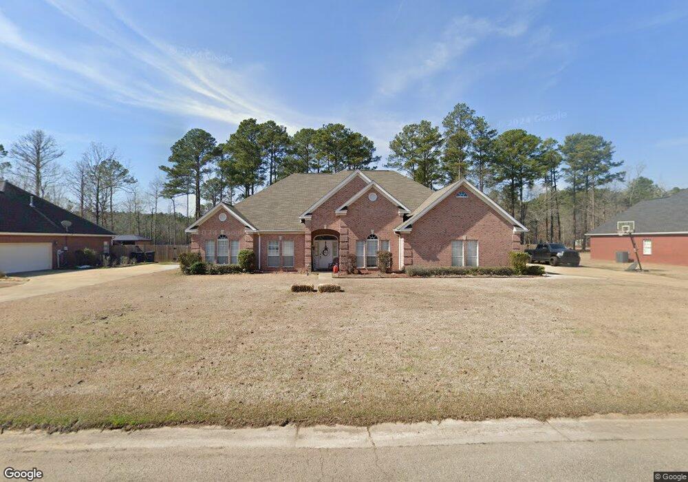
76 Kings Path Columbus, MS 39702
Estimated Value: $319,000 - $373,000
Studio
--
Bath
3,125
Sq Ft
$108/Sq Ft
Est. Value
About This Home
This home is located at 76 Kings Path, Columbus, MS 39702 and is currently estimated at $338,340, approximately $108 per square foot. 76 Kings Path is a home with nearby schools including Annunciation Catholic School.
Ownership History
Date
Name
Owned For
Owner Type
Purchase Details
Closed on
Jun 2, 2017
Sold by
Cartus Financial Corporation
Bought by
Cockrell Tanya S and Cockrell Kevin
Current Estimated Value
Purchase Details
Closed on
Apr 5, 2017
Sold by
Topps Tyronza C and Topps Kimberly Martin
Bought by
Cartus Financial Corporation
Purchase Details
Closed on
Jun 10, 2012
Sold by
Frye Karen Phillips
Bought by
Topps Tyronza C
Purchase Details
Closed on
Mar 6, 2012
Sold by
Phillips Thomas L and Phillips
Bought by
Frye Karen Ann
Create a Home Valuation Report for This Property
The Home Valuation Report is an in-depth analysis detailing your home's value as well as a comparison with similar homes in the area
Purchase History
| Date | Buyer | Sale Price | Title Company |
|---|---|---|---|
| Cockrell Tanya S | -- | None Available | |
| Cartus Financial Corporation | -- | None Available | |
| Topps Tyronza C | -- | -- | |
| Frye Karen Ann | -- | -- |
Source: Public Records
Tax History
| Year | Tax Paid | Tax Assessment Tax Assessment Total Assessment is a certain percentage of the fair market value that is determined by local assessors to be the total taxable value of land and additions on the property. | Land | Improvement |
|---|---|---|---|---|
| 2025 | $1,799 | $21,457 | $0 | $0 |
| 2024 | $1,782 | $21,457 | $0 | $0 |
| 2023 | $1,520 | $18,832 | $0 | $0 |
| 2022 | $1,521 | $18,832 | $0 | $0 |
| 2021 | $1,454 | $18,832 | $0 | $0 |
| 2020 | $1,358 | $18,832 | $0 | $0 |
| 2019 | $1,394 | $18,717 | $0 | $0 |
| 2018 | $1,394 | $18,669 | $0 | $0 |
| 2017 | $1,319 | $28,004 | $0 | $0 |
| 2016 | $1,319 | $18,669 | $0 | $0 |
| 2015 | $1,363 | $19,173 | $0 | $0 |
| 2014 | $1,363 | $19,173 | $0 | $0 |
Source: Public Records
Map
Nearby Homes
- 59 Savannah St
- 9 Monticello Cir
- 394 Pickensville Rd
- 479 Bryant Rd
- 2654 Yorkville Rd E
- 836 Oswalt Rd
- 1553 Hildreth Rd
- 20 Stokes Rd
- 338 Rogers Way
- 178 Rogers Way
- 0 Yorkville Rd E
- 17 Paige Cove
- 0 S Pickensville Rd
- 0 Nashville Ferry Rd E
- 611 Thornton Dr
- 732 Thornton Dr
- 76 Richardson Rd
- 262 Center Rd
- 0 S Lehmberg Rd
- 279 Pandora Dr
- 98 Kings Path
- 56 Kings Path
- 77 Kings Path
- 116 Kings Path
- 32 Kings Path
- 65 Kings Path
- 119 Kings Path
- 35 Kings Path
- 289 First Colony Dr
- 325 First Colony Dr
- 112 Savannah St
- 100 Savannah St
- 86 Savannah St
- 72 Savannah
- 74 Savannah
- 72 Savannah St
- 58 Savannah St
- 245 First Colony Dr
- 120 Savannah St
- 15 Old Swan Ln
Your Personal Tour Guide
Ask me questions while you tour the home.