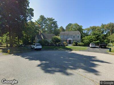
76 Station St Scituate, MA 02066
Estimated Value: $1,036,000 - $1,405,000
5
Beds
3
Baths
2,789
Sq Ft
$445/Sq Ft
Est. Value
About This Home
This home is located at 76 Station St, Scituate, MA 02066 and is currently estimated at $1,240,987, approximately $444 per square foot. 76 Station St is a home located in Plymouth County with nearby schools including Jenkins Elementary School, Lester J. Gates Middle School, and Scituate High School.
Ownership History
Date
Name
Owned For
Owner Type
Purchase Details
Closed on
Mar 22, 2021
Sold by
Cooney Peter H and Cooney Diane M
Bought by
Cooney Ryan and Cooney Alicia
Current Estimated Value
Home Financials for this Owner
Home Financials are based on the most recent Mortgage that was taken out on this home.
Original Mortgage
$724,000
Outstanding Balance
$654,887
Interest Rate
2.7%
Mortgage Type
Purchase Money Mortgage
Estimated Equity
$619,771
Purchase Details
Closed on
Feb 4, 1988
Sold by
Stone Thomas L
Bought by
Cooney Peter H
Create a Home Valuation Report for This Property
The Home Valuation Report is an in-depth analysis detailing your home's value as well as a comparison with similar homes in the area
Home Values in the Area
Average Home Value in this Area
Purchase History
| Date | Buyer | Sale Price | Title Company |
|---|---|---|---|
| Cooney Ryan | $905,000 | None Available | |
| Cooney Peter H | $170,000 | -- |
Source: Public Records
Mortgage History
| Date | Status | Borrower | Loan Amount |
|---|---|---|---|
| Open | Cooney Ryan M | $150,000 | |
| Open | Cooney Ryan | $724,000 | |
| Closed | Cooney Ryan | $724,000 | |
| Previous Owner | Wilson Kelly B | $190,000 | |
| Previous Owner | Cooney Peter H | $473,000 | |
| Previous Owner | Cooney Peter H | $64,000 | |
| Previous Owner | Cooney Peter H | $100,000 | |
| Previous Owner | Cooney Peter H | $30,000 |
Source: Public Records
Tax History Compared to Growth
Tax History
| Year | Tax Paid | Tax Assessment Tax Assessment Total Assessment is a certain percentage of the fair market value that is determined by local assessors to be the total taxable value of land and additions on the property. | Land | Improvement |
|---|---|---|---|---|
| 2025 | $10,137 | $1,014,700 | $391,100 | $623,600 |
| 2024 | $9,761 | $942,200 | $330,700 | $611,500 |
| 2023 | $9,901 | $889,600 | $317,400 | $572,200 |
| 2022 | $9,676 | $766,700 | $283,000 | $483,700 |
| 2021 | $8,792 | $659,600 | $269,500 | $390,100 |
| 2020 | $8,585 | $635,900 | $259,100 | $376,800 |
| 2019 | $8,376 | $609,600 | $254,000 | $355,600 |
| 2018 | $8,179 | $586,300 | $266,600 | $319,700 |
| 2017 | $7,945 | $563,900 | $256,000 | $307,900 |
| 2016 | $7,671 | $542,500 | $234,600 | $307,900 |
| 2015 | $6,968 | $531,900 | $224,000 | $307,900 |
Source: Public Records
Map
Nearby Homes
- 47 Pennfield Rd
- 10 Evangeline Dr
- 9 Vinal Ave
- 67 Greenfield Ln
- 111 Elm St
- Lot 4 Eisenhauer Ln
- 115 Elm St
- 218 Stockbridge Rd
- 17 Clifton Ave
- 0 Branch
- 10 Allen Place
- 260 Beaver Dam Rd
- 72 Satuit Trail
- 288 Central Ave
- 21 Hatherly Rd Unit 21
- 19 Ford Place Unit 3
- 19 Ford Place Unit 4
- 19 Ford Place Unit 1
- 24 Ladds Way Unit 24
- 5 Williamsburg Ln