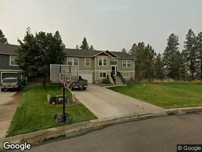
7601 N Ash Ln Spokane, WA 99208
Five Mile Prairie NeighborhoodEstimated Value: $496,588 - $530,000
4
Beds
3
Baths
3,216
Sq Ft
$157/Sq Ft
Est. Value
About This Home
This home is located at 7601 N Ash Ln, Spokane, WA 99208 and is currently estimated at $506,147, approximately $157 per square foot. 7601 N Ash Ln is a home located in Spokane County with nearby schools including Prairie View Elementary School, Northwood Middle School, and Mead Senior High School.
Ownership History
Date
Name
Owned For
Owner Type
Purchase Details
Closed on
Jan 20, 2006
Sold by
Hayden Enterprises Inc
Bought by
Wells Dale E and Wells Betty A
Current Estimated Value
Home Financials for this Owner
Home Financials are based on the most recent Mortgage that was taken out on this home.
Original Mortgage
$162,180
Interest Rate
6.32%
Mortgage Type
Fannie Mae Freddie Mac
Create a Home Valuation Report for This Property
The Home Valuation Report is an in-depth analysis detailing your home's value as well as a comparison with similar homes in the area
Home Values in the Area
Average Home Value in this Area
Purchase History
| Date | Buyer | Sale Price | Title Company |
|---|---|---|---|
| Wells Dale E | $202,730 | Transnation Title Ins Co |
Source: Public Records
Mortgage History
| Date | Status | Borrower | Loan Amount |
|---|---|---|---|
| Open | Wells Dale E | $220,000 | |
| Closed | Wells Dale E | $185,000 | |
| Closed | Wells Dale E | $195,050 | |
| Closed | Wells Dale E | $192,000 | |
| Closed | Wells Dale E | $20,000 | |
| Closed | Wells Dale E | $162,180 |
Source: Public Records
Tax History Compared to Growth
Tax History
| Year | Tax Paid | Tax Assessment Tax Assessment Total Assessment is a certain percentage of the fair market value that is determined by local assessors to be the total taxable value of land and additions on the property. | Land | Improvement |
|---|---|---|---|---|
| 2024 | $4,271 | $437,200 | $110,000 | $327,200 |
| 2023 | $3,969 | $442,600 | $110,000 | $332,600 |
| 2022 | $3,513 | $442,600 | $110,000 | $332,600 |
| 2021 | $3,251 | $300,300 | $54,000 | $246,300 |
| 2020 | $3,175 | $276,700 | $36,800 | $239,900 |
| 2019 | $2,820 | $251,600 | $36,800 | $214,800 |
| 2018 | $2,915 | $222,100 | $36,800 | $185,300 |
| 2017 | $2,783 | $213,700 | $36,800 | $176,900 |
| 2016 | $2,831 | $209,400 | $36,800 | $172,600 |
| 2015 | $2,360 | $179,700 | $36,800 | $142,900 |
| 2014 | -- | $177,700 | $36,800 | $140,900 |
| 2013 | -- | $0 | $0 | $0 |
Source: Public Records
Map
Nearby Homes
- 1512 W Christi Dr
- 1602 W Panorama Ave
- 8604 W Panorama Ave Unit Lot 3
- 8608 W Panorama Ave
- 8612 W Panorama Ave
- 8616 W Panorama Ave
- 7612 N Panorama Dr
- 7415 N Birch Ct
- 7516 N Walnut St
- 7303 N Walnut Ct
- 7520 N Cedar Rd
- 7612 N Cedar Rd
- 2101 W Kammi Ave
- 2108 W Caden Ave
- 7102 N Cannon Ct
- 1XXX W Sylvian Ct
- 2308 W Kingsford Ave
- 6916 N East Bluff Ct
- 7217 N Claney Ct
- 1710 W Rock Bluff Ct
- 7601 N Ash Ln
- 1515 W Christi Dr
- 1513 W Christi Dr
- 0 W Christi Dr
- 1540 W Christi Dr
- 7610 N Ash Ln
- 1514 W Christi Dr
- 1509 W Christi Dr
- 7609 N Ash Ln
- 7614 N Ash Ln
- 1510 W Christi Dr
- 7611 N Ash Ln
- 1507 W Christi Dr
- 7618 N Ash Ln
- 7615 N Ash Ln
- 1505 W Christi Dr
- 1509 W Trinity Ave
- 1610 W Panorama Ave
- 1506 W Christi Dr
- 1608 W Panorama Ave