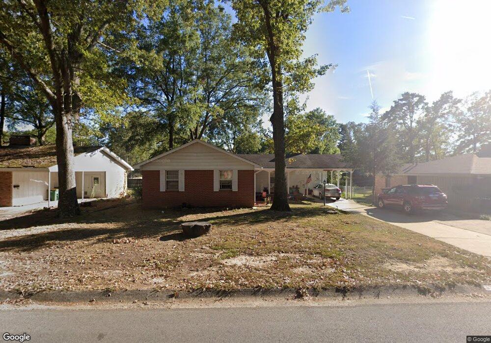
7609 Apache Rd Little Rock, AR 72205
Briarwood NeighborhoodEstimated Value: $168,000 - $191,199
3
Beds
2
Baths
1,317
Sq Ft
$139/Sq Ft
Est. Value
About This Home
This home is located at 7609 Apache Rd, Little Rock, AR 72205 and is currently estimated at $183,550, approximately $139 per square foot. 7609 Apache Rd is a home located in Pulaski County with nearby schools including Brady Elementary School, J.A. Fair K8 Preparatory School, and Central High School.
Ownership History
Date
Name
Owned For
Owner Type
Purchase Details
Closed on
Mar 28, 2011
Sold by
Neely Clarence Edward and Neely Edward
Bought by
Brewer Keith and Brewer Wendy M
Current Estimated Value
Home Financials for this Owner
Home Financials are based on the most recent Mortgage that was taken out on this home.
Original Mortgage
$97,162
Interest Rate
4.5%
Mortgage Type
FHA
Purchase Details
Closed on
Jun 9, 2003
Sold by
Neely Clarence Edward and Neely Juanita B
Bought by
Neely Clarence Edward and Neely Juanita B
Create a Home Valuation Report for This Property
The Home Valuation Report is an in-depth analysis detailing your home's value as well as a comparison with similar homes in the area
Home Values in the Area
Average Home Value in this Area
Purchase History
| Date | Buyer | Sale Price | Title Company |
|---|---|---|---|
| Brewer Keith | $104,000 | American Abstract & Title Co | |
| Neely Clarence Edward | -- | -- |
Source: Public Records
Mortgage History
| Date | Status | Borrower | Loan Amount |
|---|---|---|---|
| Previous Owner | Brewer Keith | $97,162 |
Source: Public Records
Tax History
| Year | Tax Paid | Tax Assessment Tax Assessment Total Assessment is a certain percentage of the fair market value that is determined by local assessors to be the total taxable value of land and additions on the property. | Land | Improvement |
|---|---|---|---|---|
| 2025 | $1,854 | $29,062 | $7,600 | $21,462 |
| 2024 | $1,700 | $29,062 | $7,600 | $21,462 |
| 2023 | $1,700 | $29,062 | $7,600 | $21,462 |
| 2022 | $1,623 | $29,062 | $7,600 | $21,462 |
| 2021 | $1,557 | $22,090 | $4,800 | $17,290 |
| 2020 | $1,171 | $22,090 | $4,800 | $17,290 |
| 2019 | $1,171 | $22,090 | $4,800 | $17,290 |
| 2018 | $1,140 | $22,090 | $4,800 | $17,290 |
| 2017 | $1,072 | $22,090 | $4,800 | $17,290 |
| 2016 | $1,355 | $19,350 | $5,000 | $14,350 |
| 2015 | $1,356 | $19,350 | $5,000 | $14,350 |
| 2014 | $1,356 | $19,350 | $5,000 | $14,350 |
Source: Public Records
Map
Nearby Homes
- 7800 Choctaw Rd
- 7616 Briarwood Cir
- 307 Sunnymeade Dr
- 12 Tomahawk Rd
- 7104 Briarwood Dr
- 316 Brookpark Dr
- 8301 Red Oak Ln
- 6909 Briarwood Dr
- 22 Nob Hill Cove
- 7 Brookfield Cove
- 312 Auburn Dr
- 8508 N Rodney Parham Rd
- 6615 Bluebird Dr
- 7309 Gable Dr
- 4 Pilot Point Place
- 605 N Coolidge St
- 12 Serenity Dr
- 7214 H St
- 8915 Cloverhill Rd
- 8010 Kanis Oaks Dr
- 7615 Apache Rd
- 7618 Choctaw Rd
- 7610 Choctaw Rd
- 500 S Mississippi St
- 7626 Choctaw Rd
- 524 S Mississippi St
- 7608 Apache Rd
- 7612 Apache Rd
- 7604 Apache Rd
- 7702 Choctaw Rd
- 7600 Apache Rd
- 7700 Apache Rd
- 7519 Apache Rd
- 7705 Apache Rd
- 7710 Choctaw Rd
- 7704 Apache Rd
- 7611 Choctaw Rd
- 605 Legato Dr
- 523 S Mississippi St
- 7900 Briarwood Cir
Your Personal Tour Guide
Ask me questions while you tour the home.