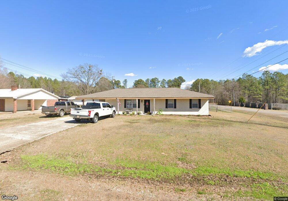
761 Beersheba Rd Columbus, MS 39702
Estimated Value: $139,160 - $205,000
3
Beds
2
Baths
1,679
Sq Ft
$109/Sq Ft
Est. Value
About This Home
This home is located at 761 Beersheba Rd, Columbus, MS 39702 and is currently estimated at $183,290, approximately $109 per square foot. 761 Beersheba Rd is a home located in Lowndes County with nearby schools including Victory Christian Academy.
Ownership History
Date
Name
Owned For
Owner Type
Purchase Details
Closed on
Sep 28, 2020
Sold by
Nester Ralyn
Bought by
Mcconell Nicole K
Current Estimated Value
Home Financials for this Owner
Home Financials are based on the most recent Mortgage that was taken out on this home.
Original Mortgage
$158,462
Outstanding Balance
$140,364
Interest Rate
2.8%
Mortgage Type
New Conventional
Estimated Equity
$42,926
Purchase Details
Closed on
Sep 28, 2018
Sold by
Ruth Steve
Bought by
Nester Ralyn
Home Financials for this Owner
Home Financials are based on the most recent Mortgage that was taken out on this home.
Original Mortgage
$118,181
Interest Rate
4.5%
Mortgage Type
New Conventional
Create a Home Valuation Report for This Property
The Home Valuation Report is an in-depth analysis detailing your home's value as well as a comparison with similar homes in the area
Purchase History
| Date | Buyer | Sale Price | Title Company |
|---|---|---|---|
| Mcconell Nicole K | -- | None Available | |
| Nester Ralyn | -- | -- |
Source: Public Records
Mortgage History
| Date | Status | Borrower | Loan Amount |
|---|---|---|---|
| Open | Mcconell Nicole K | $158,462 | |
| Previous Owner | Nester Ralyn | $118,181 |
Source: Public Records
Tax History
| Year | Tax Paid | Tax Assessment Tax Assessment Total Assessment is a certain percentage of the fair market value that is determined by local assessors to be the total taxable value of land and additions on the property. | Land | Improvement |
|---|---|---|---|---|
| 2025 | $411 | $7,208 | $0 | $0 |
| 2024 | $405 | $7,208 | $0 | $0 |
| 2023 | $357 | $6,364 | $0 | $0 |
| 2022 | $944 | $9,759 | $0 | $0 |
| 2021 | $909 | $9,759 | $0 | $0 |
| 2020 | $309 | $6,506 | $0 | $0 |
| 2019 | $929 | $6,482 | $0 | $0 |
| 2018 | $929 | $6,487 | $0 | $0 |
| 2017 | $0 | $10,245 | $0 | $0 |
| 2016 | $0 | $6,830 | $0 | $0 |
| 2015 | -- | $7,108 | $0 | $0 |
| 2014 | -- | $7,108 | $0 | $0 |
Source: Public Records
Map
Nearby Homes
- 83 Bowling Green Cir
- 127 E Cherry St
- 2746 Phillips Hill Rd
- Lot 3 Lost Lake Hills Rd
- 0 Lost Lake Hills Rd
- 220 Woodridge Place
- 72 N Colby Ln
- 72 Colby Ln
- 291 Muddy Ln
- 2362 Tabernacle Rd
- 0 Fiesta Dr
- 142 Lenox Ln
- 159 Lenox Ln
- 16 Jenny Ln
- 29 Lenox Ln
- 24 Lacy Rd
- 248 Lakeover Dr W
- 262 Center Rd
- 17 Paige Cove
- 0 Hwy Us-82
- 751 Beersheba Rd
- 731 Beersheba Rd
- 36 Beringer Rd
- 773 Mert Rickman Rd
- 786 Beersheba Rd
- 15 Viking Dr
- 747 Mert Rickman Rd
- 350 Viking Dr
- 315 Viking Dr
- 683 Beersheba Rd
- 729 Mert Rickman Rd
- 53 Viking Dr
- 324 Viking Dr
- 40 Viking Dr
- 842 Beersheba Rd
- 295 Viking Dr
- 77 Viking Dr
- 304 Viking Dr
- 275 Viking Dr
- 93 Viking Dr
Your Personal Tour Guide
Ask me questions while you tour the home.