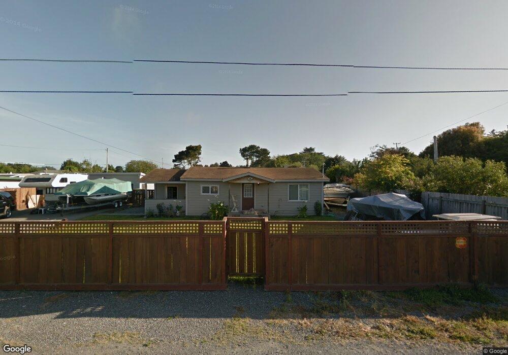
761 Wolf Rd McKinleyville, CA 95519
Estimated Value: $262,000 - $356,156
2
Beds
1
Bath
900
Sq Ft
$364/Sq Ft
Est. Value
About This Home
This home is located at 761 Wolf Rd, McKinleyville, CA 95519 and is currently estimated at $327,539, approximately $363 per square foot. 761 Wolf Rd is a home located in Humboldt County with nearby schools including Morris Elementary School, Dow's Prairie Elementary School, and McKinleyville Middle School.
Ownership History
Date
Name
Owned For
Owner Type
Purchase Details
Closed on
Mar 28, 2006
Sold by
Good Alan L
Bought by
Good Leatrice R
Current Estimated Value
Home Financials for this Owner
Home Financials are based on the most recent Mortgage that was taken out on this home.
Original Mortgage
$176,000
Outstanding Balance
$109,588
Interest Rate
7.85%
Mortgage Type
Fannie Mae Freddie Mac
Estimated Equity
$217,951
Create a Home Valuation Report for This Property
The Home Valuation Report is an in-depth analysis detailing your home's value as well as a comparison with similar homes in the area
Home Values in the Area
Average Home Value in this Area
Purchase History
| Date | Buyer | Sale Price | Title Company |
|---|---|---|---|
| Good Leatrice R | -- | Fidelity National Title Comp | |
| Good Leatrice R | $220,000 | Fidelity National Title Comp |
Source: Public Records
Mortgage History
| Date | Status | Borrower | Loan Amount |
|---|---|---|---|
| Open | Good Leatrice R | $176,000 | |
| Closed | Good Leatrice R | $44,000 |
Source: Public Records
Tax History Compared to Growth
Tax History
| Year | Tax Paid | Tax Assessment Tax Assessment Total Assessment is a certain percentage of the fair market value that is determined by local assessors to be the total taxable value of land and additions on the property. | Land | Improvement |
|---|---|---|---|---|
| 2025 | $3,406 | $300,630 | $184,479 | $116,151 |
| 2024 | $3,406 | $294,736 | $180,862 | $113,874 |
| 2023 | $3,327 | $288,958 | $177,316 | $111,642 |
| 2022 | $3,344 | $283,293 | $173,840 | $109,453 |
| 2021 | $3,188 | $277,739 | $170,432 | $107,307 |
| 2020 | $3,107 | $274,892 | $168,685 | $106,207 |
| 2019 | $3,086 | $269,503 | $165,378 | $104,125 |
| 2018 | $2,968 | $264,220 | $162,136 | $102,084 |
| 2017 | $2,892 | $259,040 | $158,957 | $100,083 |
| 2016 | $2,840 | $253,962 | $155,841 | $98,121 |
| 2015 | $2,785 | $250,149 | $153,501 | $96,648 |
| 2014 | $2,743 | $245,250 | $150,495 | $94,755 |
Source: Public Records
Map
Nearby Homes
- 1133 Chelsea Way
- 1090 Fritz Rd
- 1163 Chelsea Way
- 1181 Chelsea Way
- 2150 Thiel Ave
- 1525 Salmon Ave
- 1250 School Rd
- 2257 Walnut Ave
- 442 Mad River Rd
- 1320 Brady Ct
- 2331 Central Ave
- 2911 Sandpointe Dr
- 2910 Springer Dr
- 2951 Sandpointe Dr
- 3002 Sandpointe Dr
- 2973 Springer Dr
- 1212 Mad River Rd
- 2032 Nelson Rd
- 1050 Seahome Ct
- 3077 Sandpointe Dr
- 753 Wolf Rd
- 1750 Fischer Ave
- 1780 Fischer Ave
- 1770 Fischer Ave
- 1755 Fischer Rd
- 745 Wolf Rd
- 1736 Fischer Ave
- 760 Montana Rd
- 784 Montana Rd
- 733 Wolf Rd
- 1785 Lost Ave
- 734 Wolf Rd
- 1794 Fischer Ave
- 1720 Fischer Ave
- 1761 Fischer Ave
- 1791 Lost Ave
- 1781 Fischer Ave
- 1750 Lost Ave
- 1780 Lost Ave
- 1708 Fischer Ave