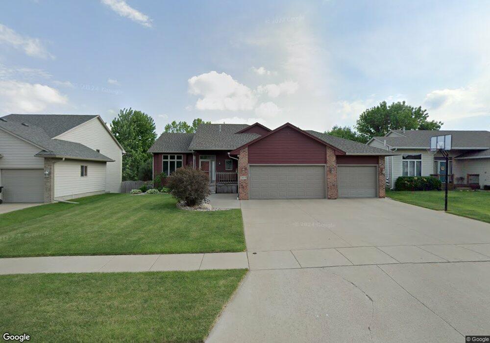
7613 W Emily St Sioux Falls, SD 57106
Northwest Sioux Falls NeighborhoodEstimated Value: $418,000 - $445,000
4
Beds
3
Baths
2,509
Sq Ft
$171/Sq Ft
Est. Value
About This Home
This home is located at 7613 W Emily St, Sioux Falls, SD 57106 and is currently estimated at $429,561, approximately $171 per square foot. 7613 W Emily St is a home located in Minnehaha County with nearby schools including Discovery Elementary School, Memorial Middle School, and Jefferson High School - 67.
Ownership History
Date
Name
Owned For
Owner Type
Purchase Details
Closed on
Sep 1, 2023
Sold by
Parker Roger A and Parker Rebecca R
Bought by
Foltz Noah and Schartz Rachel
Current Estimated Value
Home Financials for this Owner
Home Financials are based on the most recent Mortgage that was taken out on this home.
Original Mortgage
$373,500
Outstanding Balance
$365,489
Interest Rate
6.9%
Estimated Equity
$64,072
Create a Home Valuation Report for This Property
The Home Valuation Report is an in-depth analysis detailing your home's value as well as a comparison with similar homes in the area
Home Values in the Area
Average Home Value in this Area
Purchase History
| Date | Buyer | Sale Price | Title Company |
|---|---|---|---|
| Foltz Noah | $415,000 | Stewart Title Co | |
| Foltz Noah | $415,000 | Stewart Title Co |
Source: Public Records
Mortgage History
| Date | Status | Borrower | Loan Amount |
|---|---|---|---|
| Open | Foltz Noah | $373,500 | |
| Closed | Foltz Noah | $373,500 |
Source: Public Records
Tax History
| Year | Tax Paid | Tax Assessment Tax Assessment Total Assessment is a certain percentage of the fair market value that is determined by local assessors to be the total taxable value of land and additions on the property. | Land | Improvement |
|---|---|---|---|---|
| 2024 | $5,232 | $388,200 | $34,900 | $353,300 |
| 2023 | $4,822 | $343,800 | $30,700 | $313,100 |
| 2022 | $4,534 | $304,600 | $30,700 | $273,900 |
| 2021 | $3,849 | $268,100 | $0 | $0 |
| 2020 | $3,849 | $247,500 | $0 | $0 |
| 2019 | $3,857 | $243,738 | $0 | $0 |
| 2018 | $3,575 | $241,959 | $0 | $0 |
| 2017 | $3,416 | $226,884 | $32,120 | $194,764 |
| 2016 | $3,416 | $216,722 | $32,120 | $184,602 |
| 2015 | $3,334 | $203,176 | $30,429 | $172,747 |
| 2014 | -- | $198,173 | $30,507 | $167,666 |
Source: Public Records
Map
Nearby Homes
- 7508 W Alexandra St
- 7212 W Strabane St
- 1516 S Kinderhook Ave
- 8101 W 24th St
- 8105 W 24th St
- 2010 S Barret Place Unit 46
- 8506 W Lavern Wipf St Unit 12
- 0 S Ellis Rd
- 8509 W Grinn Place Unit 33
- 2409 S Grinnell Ave
- 1400 S Hyde Park Ave
- 1501 S Wheatland Ave
- 8611 W Grinn Place Unit 18
- 2412 S Purdue Ave
- 1301 S Hyannis Port Ln
- 1810 S Campbell Trail
- 2024 S Shaw Ave
- 1201 S Montpelier Ave Ave
- 2601 S Rutgers Ave
- 7409 W Harvard Dr
- 7609 W Emily St
- 7617 W Emily St
- 7605 W Emily St
- 7612 W Regina St
- 7621 W Emily St
- 7616 W Regina St
- 7608 W Emily St
- 7612 W Emily St
- 7608 W Regina St
- 7604 W Emily St
- 7620 W Regina St
- 7601 W Emily St
- 7701 W Emily St
- 7604 W Regina St
- 7616 W Emily St
- 7600 W Emily St
- 7700 W Regina St
- 7700 W Emily St
- 7600 W Regina St
- 7705 W Emily St
Your Personal Tour Guide
Ask me questions while you tour the home.