Estimated payment $1,588/month
Highlights
- Mountain View
- No HOA
- No Heating
- Corner Lot
- Partially Fenced Property
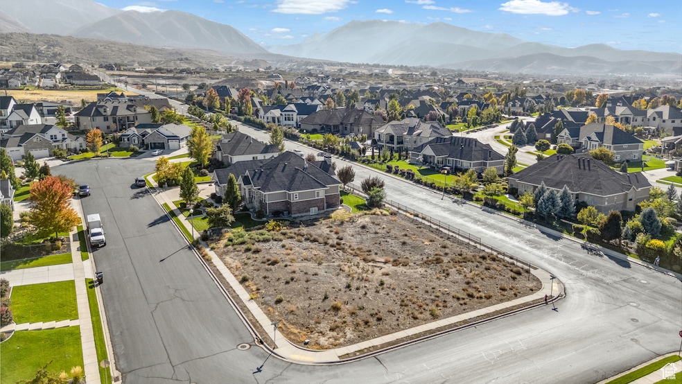
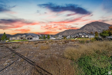
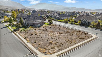
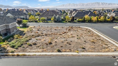
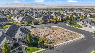
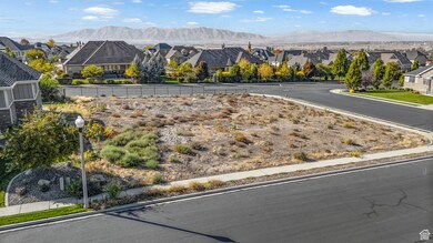
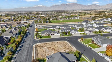
About This Lot
This spectacular 0.34-acre lot offers breathtaking, unobstructed views of Mount Loafer, making it the ideal setting for your dream home. Nestled in a peaceful, well-established community, this parcel provides the perfect balance of privacy and convenience. Don't miss the chance to build your perfect retreat in this exceptional location!
Property Details
Property Type
- Land
Est. Annual Taxes
- $2,306
Lot Details
- 0.34 Acre Lot
- Lot Dimensions are 136.0x137.0x136.0
- East Facing Home
- Partially Fenced Property
- Corner Lot
- Sloped Lot
- Property is zoned Single-Family, R-15
Property Views
- Mountain
- Valley
Schools
- Foothills Elementary School
- Salem Jr Middle School
- Salem Hills High School
Community Details
- No Home Owners Association
- Ridge Subdivision
Listing and Financial Details
- Assessor Parcel Number 55-785-0007
Map
Home Values in the Area
Average Home Value in this Area
Tax History
| Year | Tax Paid | Tax Assessment Tax Assessment Total Assessment is a certain percentage of the fair market value that is determined by local assessors to be the total taxable value of land and additions on the property. | Land | Improvement |
|---|---|---|---|---|
| 2025 | $2,212 | $235,500 | $235,500 | -- |
| 2024 | $2,212 | $224,300 | $0 | $0 |
| 2023 | $2,144 | $217,800 | $0 | $0 |
| 2022 | $2,185 | $218,600 | $218,600 | $0 |
| 2021 | $1,547 | $136,600 | $136,600 | $0 |
| 2020 | $1,446 | $124,200 | $124,200 | $0 |
| 2019 | $1,307 | $114,700 | $114,700 | $0 |
| 2018 | $1,368 | $114,700 | $114,700 | $0 |
| 2017 | $1,197 | $97,300 | $0 | $0 |
| 2016 | $1,131 | $90,900 | $0 | $0 |
| 2015 | $1,051 | $83,000 | $0 | $0 |
Property History
| Date | Event | Price | List to Sale | Price per Sq Ft |
|---|---|---|---|---|
| 02/10/2026 02/10/26 | Price Changed | $268,900 | -3.6% | -- |
| 01/12/2026 01/12/26 | Price Changed | $278,900 | -2.1% | -- |
| 10/06/2025 10/06/25 | For Sale | $284,900 | -- | -- |
Purchase History
| Date | Type | Sale Price | Title Company |
|---|---|---|---|
| Warranty Deed | -- | Gt Title Services | |
| Warranty Deed | -- | Gt Title Svcs Spanish Fork | |
| Warranty Deed | -- | North American Title |
Mortgage History
| Date | Status | Loan Amount | Loan Type |
|---|---|---|---|
| Previous Owner | $916,000 | Purchase Money Mortgage |
Source: UtahRealEstate.com
MLS Number: 2115880
APN: 55-785-0007
Disclaimer: Certain information contained herein is derived from information provided by parties other than Homes.com. All information provided is deemed reliable, but is not guaranteed to be accurate and should be independently verified.
![]() IDX information is provided exclusively for consumers’ personal, non-commercial use, that it may not be used for any purpose other than to identify prospective properties consumers may be interested in purchasing, and that the data is deemed reliable but is not guaranteed accurate by the MLS. Licensor is only providing the MLS Content and not other sources of data provided in the Product.
IDX information is provided exclusively for consumers’ personal, non-commercial use, that it may not be used for any purpose other than to identify prospective properties consumers may be interested in purchasing, and that the data is deemed reliable but is not guaranteed accurate by the MLS. Licensor is only providing the MLS Content and not other sources of data provided in the Product.
Based on information from the Wasatch Front Regional Multiple Listing Service, Inc.. All data, including all measurements and calculations of area, is obtained from various sources and has not been, and will not be, verified by broker or the MLS. All information should be independently reviewed and verified for accuracy. Properties may or may not be listed by the office/agent presenting the information.
- 1312 E 1020 S Unit 1
- 1336 E 1020 S Unit 2
- 1043 S 900 E
- 1072 S 925 E
- 553 Strawberry Rd
- 1137 S 925 E
- 1157 S 925 E
- 1376 E 1280 S Unit 6-22
- 1939 E Dorset Way Unit 306
- 1968 E Dorset Way
- 1962 E Dorset Way
- 1948 E Dorset Way Unit 274
- 1965 E Dorset Way Unit 303
- 1558 E 1010 N Unit 203
- 1562 E 960 N Unit 197
- 1802 E Albion Dr Unit 1142
- 1962 E Dorset Way Unit 276
- 1949 E Dorset Way Unit 305
- 1968 E Dorset Way Unit 277
- 881 E 820 S
- 1744 E Albion Dr
- 1361 E 50 S
- 2243 S 310 W
- 1436 E 820 N
- 1461 E 100 S
- 62 S 1400 E
- 67 W Summit Dr
- 32 E Utah Ave Unit 205
- 2086 E 1480 S
- 952 S 1350 E Unit Daylight Walk-Out Suite
- 752 N 400 W
- 771 S 900 E
- 723 Desert Willow Dr
- 755 E 100 N
- 4655 S Alder Dr Unit H204
- 3331 E 700 S Unit Apartment—3 Beds
- 496 N 500 E
- 368 N Diamond Fork Loop
- 681 N Valley Dr
- 358 N 2810 E

Ask me questions while you tour the home.