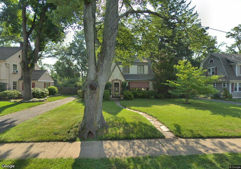
762 Hawthorne Ave Bound Brook, NJ 08805
Estimated Value: $484,474 - $598,000
--
Bed
--
Bath
1,632
Sq Ft
$345/Sq Ft
Est. Value
About This Home
This home is located at 762 Hawthorne Ave, Bound Brook, NJ 08805 and is currently estimated at $562,619, approximately $344 per square foot. 762 Hawthorne Ave is a home located in Somerset County with nearby schools including Adamsville Primary School, Bridgewater-Raritan Middle School, and Hillside Intermediate School.
Ownership History
Date
Name
Owned For
Owner Type
Purchase Details
Closed on
Apr 7, 1998
Sold by
Rarigh Scott Wilson
Bought by
Lathrop Richard and Lathrop Suzanne
Current Estimated Value
Home Financials for this Owner
Home Financials are based on the most recent Mortgage that was taken out on this home.
Original Mortgage
$167,000
Interest Rate
7.05%
Purchase Details
Closed on
Sep 5, 1995
Sold by
Bedell William
Bought by
Rairigh Scott and Rairigh Karen
Home Financials for this Owner
Home Financials are based on the most recent Mortgage that was taken out on this home.
Original Mortgage
$209,000
Interest Rate
7.81%
Create a Home Valuation Report for This Property
The Home Valuation Report is an in-depth analysis detailing your home's value as well as a comparison with similar homes in the area
Home Values in the Area
Average Home Value in this Area
Purchase History
| Date | Buyer | Sale Price | Title Company |
|---|---|---|---|
| Lathrop Richard | $240,000 | -- | |
| Rairigh Scott | $220,000 | -- |
Source: Public Records
Mortgage History
| Date | Status | Borrower | Loan Amount |
|---|---|---|---|
| Previous Owner | Lathrop Richard | $167,000 | |
| Previous Owner | Rairigh Scott | $209,000 |
Source: Public Records
Tax History Compared to Growth
Tax History
| Year | Tax Paid | Tax Assessment Tax Assessment Total Assessment is a certain percentage of the fair market value that is determined by local assessors to be the total taxable value of land and additions on the property. | Land | Improvement |
|---|---|---|---|---|
| 2025 | $7,452 | $382,000 | $213,500 | $168,500 |
| 2024 | $7,452 | $378,100 | $213,500 | $164,600 |
| 2023 | $7,133 | $355,400 | $213,500 | $141,900 |
| 2022 | $6,903 | $330,900 | $208,500 | $122,400 |
| 2021 | $6,574 | $309,300 | $208,500 | $100,800 |
| 2020 | $6,552 | $307,900 | $208,500 | $99,400 |
| 2019 | $6,574 | $305,900 | $208,500 | $97,400 |
| 2018 | $6,505 | $303,400 | $208,500 | $94,900 |
| 2017 | $6,378 | $297,200 | $208,500 | $88,700 |
| 2016 | $5,890 | $278,500 | $193,500 | $85,000 |
| 2015 | $5,853 | $277,000 | $193,500 | $83,500 |
| 2014 | $5,854 | $272,900 | $193,500 | $79,400 |
Source: Public Records
Map
Nearby Homes
- 811 Mountain Ave
- 807 Watchung Rd
- 180 Farm Ln
- 650 Central Ave
- 745 Schoolhouse Ln
- 1891 Middlebrook Rd
- 363 Grant Ave
- 205 Ashland Rd
- 563 Winsor St
- 14 E Maple Ave
- 1820 Woodland Terrace
- 311 Ashland Rd
- 520 Winsor St
- 112 E Union Ave
- 116 Greene Ave
- 149 Mulberry Ln
- 112-114 E Union Ave
- 320 Church St
- 27 Shearn Dr
- 231 Fairview Ave
- 768 Hawthorne Ave
- 756 Hawthorne Ave
- 770 Hawthorne Ave
- 750 Hawthorne Ave
- 778 Hawthorne Ave
- 759 Hawthorne Ave
- 767 Hawthorne Ave
- 744 Hawthorne Ave
- 747 Hawthorne Ave
- 775 Hawthorne Ave
- 740 Hawthorne Ave
- 260 Shepherd Ave
- 248 Shepherd Ave
- 737 Hawthorne Ave
- 736 Hawthorne Ave
- 242 Shepherd Ave
- 762 Park Ave
- 766 Park Ave
- 750 Park Ave
- 733 Hawthorne Ave