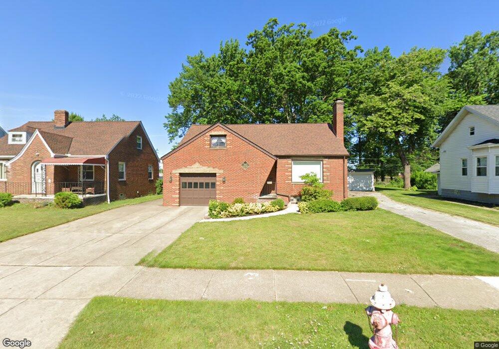
764 E 232nd St Euclid, OH 44123
Estimated Value: $146,486 - $174,000
2
Beds
2
Baths
1,587
Sq Ft
$99/Sq Ft
Est. Value
About This Home
This home is located at 764 E 232nd St, Euclid, OH 44123 and is currently estimated at $156,622, approximately $98 per square foot. 764 E 232nd St is a home located in Cuyahoga County with nearby schools including Arbor Elementary School, Euclid Middle School, and Euclid High School.
Ownership History
Date
Name
Owned For
Owner Type
Purchase Details
Closed on
Aug 2, 1996
Sold by
Caimi Shirley
Bought by
Jansa Thomas
Current Estimated Value
Home Financials for this Owner
Home Financials are based on the most recent Mortgage that was taken out on this home.
Original Mortgage
$76,800
Interest Rate
8.33%
Mortgage Type
New Conventional
Purchase Details
Closed on
Feb 17, 1987
Sold by
Kenneth L Mitchell
Bought by
Lindic Carol Ann
Purchase Details
Closed on
Dec 16, 1980
Sold by
Mitchell Kenneth L
Bought by
Kenneth L Mitchell
Purchase Details
Closed on
Aug 20, 1976
Sold by
Mitchell Kenneth L and Mitchell Beverly
Bought by
Mitchell Kenneth L
Purchase Details
Closed on
Jan 1, 1975
Bought by
Mitchell Kenneth L and Mitchell Beverly
Create a Home Valuation Report for This Property
The Home Valuation Report is an in-depth analysis detailing your home's value as well as a comparison with similar homes in the area
Home Values in the Area
Average Home Value in this Area
Purchase History
| Date | Buyer | Sale Price | Title Company |
|---|---|---|---|
| Jansa Thomas | $96,000 | -- | |
| Lindic Carol Ann | $61,000 | -- | |
| Kenneth L Mitchell | -- | -- | |
| Mitchell Kenneth L | -- | -- | |
| Mitchell Kenneth L | -- | -- |
Source: Public Records
Mortgage History
| Date | Status | Borrower | Loan Amount |
|---|---|---|---|
| Closed | Jansa Thomas | $76,800 |
Source: Public Records
Tax History
| Year | Tax Paid | Tax Assessment Tax Assessment Total Assessment is a certain percentage of the fair market value that is determined by local assessors to be the total taxable value of land and additions on the property. | Land | Improvement |
|---|---|---|---|---|
| 2024 | $3,149 | $45,885 | $10,115 | $35,770 |
| 2023 | $2,156 | $24,510 | $7,950 | $16,560 |
| 2022 | $2,108 | $24,500 | $7,950 | $16,560 |
| 2021 | $2,340 | $24,500 | $7,950 | $16,560 |
| 2020 | $1,969 | $18,550 | $6,020 | $12,530 |
| 2019 | $1,767 | $53,000 | $17,200 | $35,800 |
| 2018 | $893 | $18,550 | $6,020 | $12,530 |
| 2017 | $2,109 | $18,480 | $3,990 | $14,490 |
| 2016 | $2,114 | $18,480 | $3,990 | $14,490 |
| 2015 | $1,927 | $18,480 | $3,990 | $14,490 |
| 2014 | $1,927 | $18,480 | $3,990 | $14,490 |
Source: Public Records
Map
Nearby Homes
- 797 Babbitt Rd Unit 15
- 942 E 236th St
- 442 Clearview Dr Unit U9
- 21971 Crystal Ave
- 22931 Arms Ave
- 22751 Fox Ave
- 521 Kenwood Dr Unit B-5
- 422 Clearview Dr Unit J10
- 21670 Crystal Ave
- 421 Kenwood Dr Unit G
- 450 Kenwood Dr Unit D-12
- 461 Kenwood Dr Unit T3
- 21481 Ball Ave
- 890 E 250th St
- 24431 Hartland Rd
- 21250 Wilmore Ave
- 21170 Wilmore Ave
- 934 E 223rd St
- 21181 Ball Ave
- 336 E 222nd St
Your Personal Tour Guide
Ask me questions while you tour the home.