Estimated Value: $290,000 - $378,000
4
Beds
2
Baths
1,643
Sq Ft
$198/Sq Ft
Est. Value
About This Home
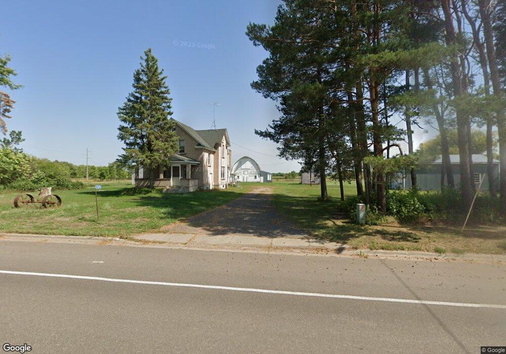
This home is located at 7674 Ronneby Rd NE, Foley, MN 56329 and is currently estimated at $325,430, approximately $198 per square foot. 7674 Ronneby Rd NE is a home located in Benton County with nearby schools including Foley Elementary School, Foley Intermediate Elementary School, and Foley Senior High School.
Ownership History
Date
Name
Owned For
Owner Type
Purchase Details
Closed on
Jun 21, 2024
Sold by
Weaver Allen and Weaver Allen R
Bought by
Porter Susan G
Current Estimated Value
Home Financials for this Owner
Home Financials are based on the most recent Mortgage that was taken out on this home.
Original Mortgage
$186,000
Outstanding Balance
$184,413
Interest Rate
9.06%
Mortgage Type
New Conventional
Estimated Equity
$141,017
Create a Home Valuation Report for This Property
The Home Valuation Report is an in-depth analysis detailing your home's value as well as a comparison with similar homes in the area
Home Values in the Area
Average Home Value in this Area
Purchase History
| Date | Buyer | Sale Price | Title Company |
|---|---|---|---|
| Porter Susan G | $286,000 | Home Security Abstract & Title |
Source: Public Records
Mortgage History
| Date | Status | Borrower | Loan Amount |
|---|---|---|---|
| Open | Porter Susan G | $186,000 |
Source: Public Records
Tax History Compared to Growth
Tax History
| Year | Tax Paid | Tax Assessment Tax Assessment Total Assessment is a certain percentage of the fair market value that is determined by local assessors to be the total taxable value of land and additions on the property. | Land | Improvement |
|---|---|---|---|---|
| 2025 | $1,584 | $189,500 | $101,200 | $88,300 |
| 2024 | $836 | $185,500 | $100,100 | $85,400 |
| 2023 | $832 | $187,100 | $100,100 | $87,000 |
| 2022 | $942 | $173,700 | $92,000 | $81,700 |
| 2021 | $842 | $162,800 | $82,500 | $80,300 |
| 2018 | $974 | $111,000 | $65,471 | $45,529 |
| 2017 | $974 | $106,500 | $64,920 | $41,580 |
| 2016 | $988 | $135,900 | $74,300 | $61,600 |
| 2015 | $874 | $96,600 | $63,486 | $33,114 |
| 2014 | -- | $95,300 | $60,519 | $34,781 |
| 2013 | -- | $103,900 | $64,642 | $39,258 |
Source: Public Records
Map
Nearby Homes
- 142xx 80th St NE
- TBD 90th St NE
- TBD 11th Ave
- 8105 165th Ave NE
- 330 7th Ave
- TBD Field House Rd
- 130 Broadway Ave S
- 191 4th Ave S
- 409 4th Ave N
- 501 4th Ave N
- 709 Norman Ave N
- 17131 65th St NE
- 320 Oak Dr
- 131 Norman Ave N
- 17061 90th St NE
- 52 Glen St Unit 10
- 201 Norman Ave S
- 510 Morgan Dr
- 400 Kathryn Ln
- XXX Hwy 25
- 7636 Ronneby Rd NE
- 7665 Ronneby Rd NE
- 18939 Highway 23 NE
- 14414 78th St NE
- 7595 Ronneby Rd NE
- 14370 77th St NE
- 14478 78th St NE
- 7645 Ronneby Rd NE
- 0000 77th St NE
- 14370 78th St NE
- 14405 78th St NE
- 14405 78th St NE
- 14351 78th St NE
- 7565 Ronneby Rd NE
- 14301 78th St NE
- 14270 77th St NE
- 14276 78th St NE
- 14280 78th St NE
- 7971 Ronneby Rd NE
- 14260 78th St NE