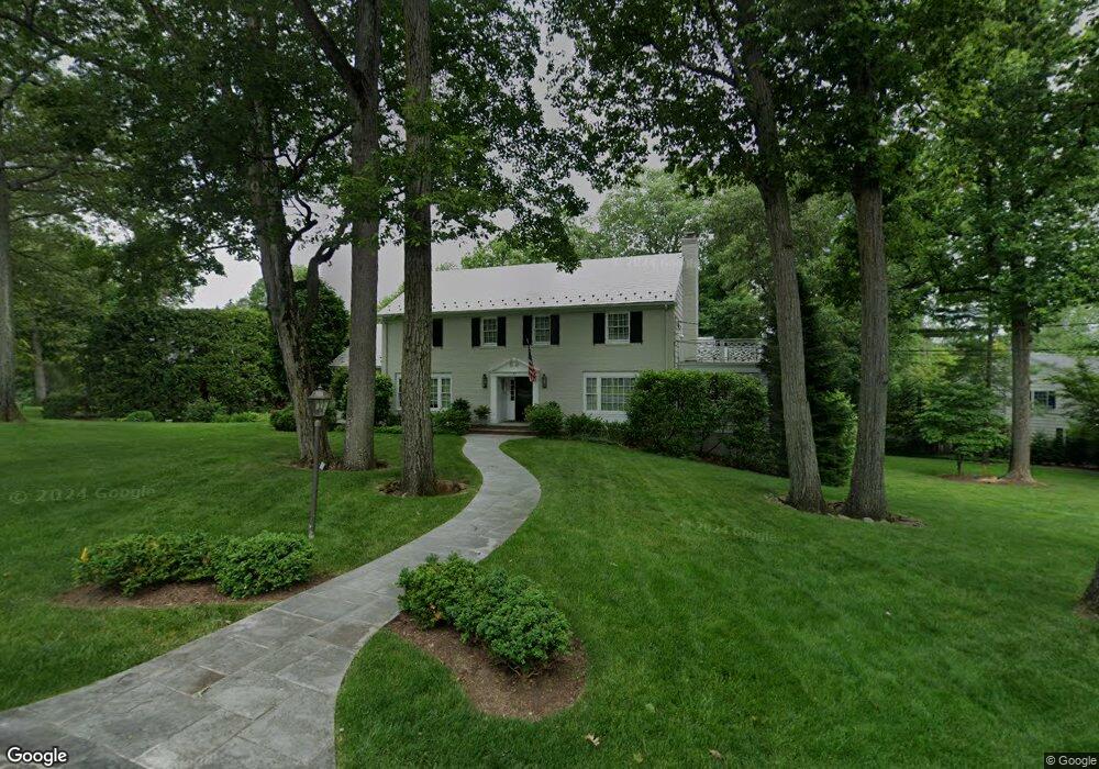
77 Colt Rd Summit, NJ 07901
Estimated Value: $2,230,062 - $3,473,000
Studio
--
Bath
4,187
Sq Ft
$667/Sq Ft
Est. Value
About This Home
This home is located at 77 Colt Rd, Summit, NJ 07901 and is currently estimated at $2,793,016, approximately $667 per square foot. 77 Colt Rd is a home located in Union County with nearby schools including L C Johnson Summit Middle School, Summit Sr High School, and Oak Knoll School of the Holy Child.
Ownership History
Date
Name
Owned For
Owner Type
Purchase Details
Closed on
Jun 20, 2007
Sold by
Corcoran Francis X
Bought by
Pacilio Vincent L and Kitson Linda L
Current Estimated Value
Home Financials for this Owner
Home Financials are based on the most recent Mortgage that was taken out on this home.
Original Mortgage
$600,000
Outstanding Balance
$355,060
Interest Rate
5.59%
Mortgage Type
Purchase Money Mortgage
Estimated Equity
$2,437,956
Purchase Details
Closed on
Nov 21, 2000
Sold by
Taylor Thomas P and Taylor Corinne M
Bought by
Corcoran Francis X and Corcoran Elizabeth Wyman
Home Financials for this Owner
Home Financials are based on the most recent Mortgage that was taken out on this home.
Original Mortgage
$1,050,000
Interest Rate
7.37%
Create a Home Valuation Report for This Property
The Home Valuation Report is an in-depth analysis detailing your home's value as well as a comparison with similar homes in the area
Home Values in the Area
Average Home Value in this Area
Purchase History
| Date | Buyer | Sale Price | Title Company |
|---|---|---|---|
| Pacilio Vincent L | $2,431,000 | None Available | |
| Corcoran Francis X | $1,534,500 | -- |
Source: Public Records
Mortgage History
| Date | Status | Borrower | Loan Amount |
|---|---|---|---|
| Open | Pacilio Vincent L | $600,000 | |
| Previous Owner | Corcoran Francis X | $1,050,000 |
Source: Public Records
Tax History
| Year | Tax Paid | Tax Assessment Tax Assessment Total Assessment is a certain percentage of the fair market value that is determined by local assessors to be the total taxable value of land and additions on the property. | Land | Improvement |
|---|---|---|---|---|
| 2025 | $35,388 | $812,400 | $389,900 | $422,500 |
| 2024 | $35,153 | $812,400 | $389,900 | $422,500 |
| 2023 | $35,153 | $812,400 | $389,900 | $422,500 |
| 2022 | $34,795 | $812,400 | $389,900 | $422,500 |
| 2021 | $40,541 | $939,100 | $389,900 | $549,200 |
| 2020 | $40,945 | $939,100 | $389,900 | $549,200 |
| 2019 | $40,992 | $939,100 | $389,900 | $549,200 |
| 2018 | $40,729 | $939,100 | $389,900 | $549,200 |
| 2017 | $40,992 | $939,100 | $389,900 | $549,200 |
| 2016 | $40,391 | $939,100 | $389,900 | $549,200 |
| 2015 | $39,602 | $939,100 | $389,900 | $549,200 |
| 2014 | $38,578 | $939,100 | $389,900 | $549,200 |
Source: Public Records
Map
Nearby Homes
- 22 Brook Hollow Ln
- 226 Mountain Ave
- 71 Dale Dr
- 78 Seven Oaks Dr
- 65 Seven Oaks Dr
- 4 Parkview Terrace
- 25 Division Ave
- 709 Springfield Ave Unit One
- 709 Springfield Ave Unit 4
- 709 Springfield Ave Unit 2
- 709 Springfield Ave Unit 3
- 105 Larned Rd
- 157 Grant Ave
- 49 the Fellsway
- 15 Alison Ct
- 88 Beekman Rd
- 17 Badgley Dr
- 113 Crest Dr
- 63 Gallinson Dr
- 67 Tulip St
Your Personal Tour Guide
Ask me questions while you tour the home.