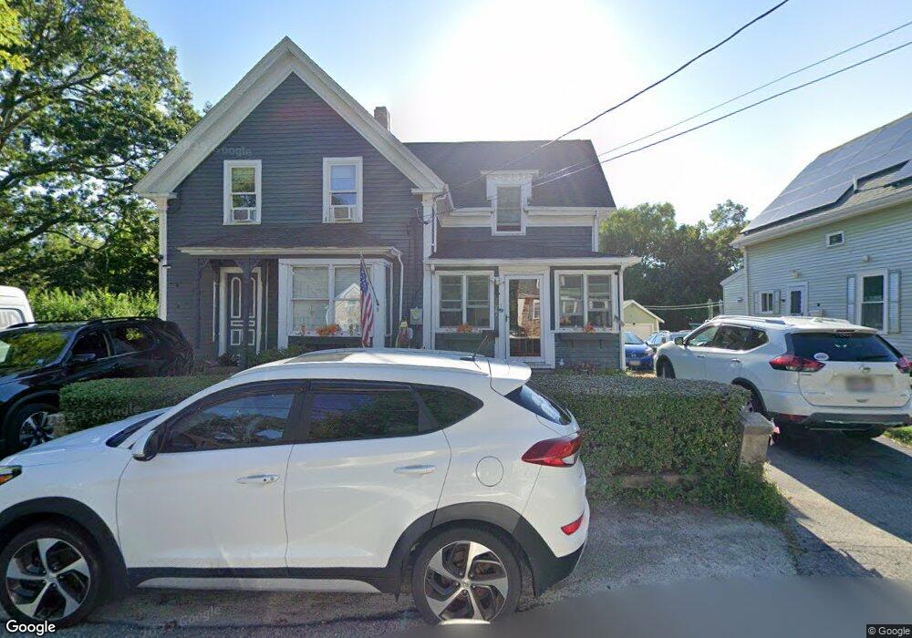
77 High St Gloucester, MA 01930
Estimated Value: $707,000 - $806,000
4
Beds
3
Baths
2,226
Sq Ft
$344/Sq Ft
Est. Value
About This Home
This home is located at 77 High St, Gloucester, MA 01930 and is currently estimated at $764,908, approximately $343 per square foot. 77 High St is a home located in Essex County with nearby schools including Plum Cove School, Ralph B O'maley Middle School, and Gloucester High School.
Ownership History
Date
Name
Owned For
Owner Type
Purchase Details
Closed on
Aug 23, 2019
Sold by
Gorrell Robert E
Bought by
Gorrell-Story Marsha and Story Michael
Current Estimated Value
Home Financials for this Owner
Home Financials are based on the most recent Mortgage that was taken out on this home.
Original Mortgage
$315,000
Outstanding Balance
$275,882
Interest Rate
3.7%
Mortgage Type
New Conventional
Estimated Equity
$489,026
Create a Home Valuation Report for This Property
The Home Valuation Report is an in-depth analysis detailing your home's value as well as a comparison with similar homes in the area
Purchase History
| Date | Buyer | Sale Price | Title Company |
|---|---|---|---|
| Gorrell-Story Marsha | $450,000 | -- |
Source: Public Records
Mortgage History
| Date | Status | Borrower | Loan Amount |
|---|---|---|---|
| Open | Gorrell-Story Marsha | $315,000 |
Source: Public Records
Tax History
| Year | Tax Paid | Tax Assessment Tax Assessment Total Assessment is a certain percentage of the fair market value that is determined by local assessors to be the total taxable value of land and additions on the property. | Land | Improvement |
|---|---|---|---|---|
| 2025 | $5,919 | $608,900 | $263,300 | $345,600 |
| 2024 | $5,771 | $593,100 | $250,700 | $342,400 |
| 2023 | $5,879 | $555,100 | $223,900 | $331,200 |
| 2022 | $5,496 | $468,500 | $190,300 | $278,200 |
| 2021 | $5,313 | $427,100 | $173,000 | $254,100 |
| 2020 | $5,089 | $412,700 | $173,000 | $239,700 |
| 2019 | $5,264 | $414,800 | $173,000 | $241,800 |
| 2018 | $5,003 | $386,900 | $173,000 | $213,900 |
| 2017 | $4,800 | $363,900 | $164,800 | $199,100 |
| 2016 | $4,693 | $344,800 | $165,200 | $179,600 |
| 2015 | $4,630 | $339,200 | $165,200 | $174,000 |
Source: Public Records
Map
Nearby Homes
- 43 High St Unit B
- 9 Hickory St
- 1030 Washington St
- 5 Viking St Unit A
- 22 Woodbury St
- 7 Colburn St
- 4 Ciaramitaro Ct
- 136 Leonard St
- 14 1/2 Story St Unit B
- 17 Story St
- 165 Granite St
- 13 Phillips Ave
- 94 Phillips Ave
- 5 Boulder Top
- 32 Haven Ave
- 13 Rowe Point
- 3 Vine Ave
- 5 Smith St Unit R
- 15 Beach St
- 672 Washington St
Your Personal Tour Guide
Ask me questions while you tour the home.