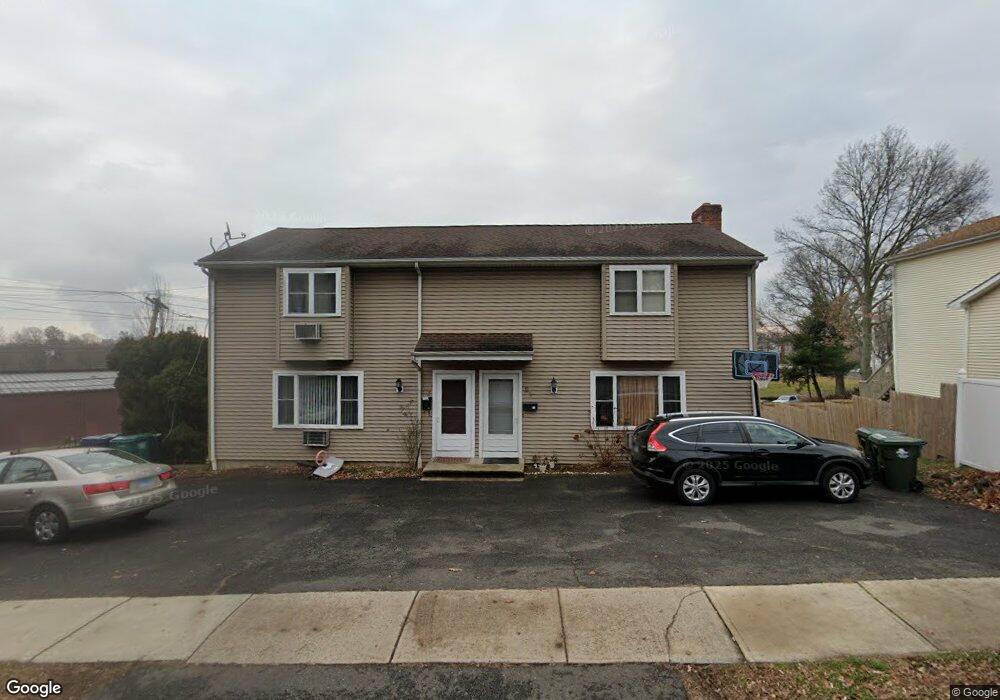
77 Jennings Rd Fairfield, CT 06825
Tunxis Hill NeighborhoodEstimated Value: $683,000 - $985,000
5
Beds
4
Baths
2,538
Sq Ft
$312/Sq Ft
Est. Value
About This Home
This home is located at 77 Jennings Rd, Fairfield, CT 06825 and is currently estimated at $791,939, approximately $312 per square foot. 77 Jennings Rd is a home located in Fairfield County with nearby schools including Mckinley Elementary School, Tomlinson Middle School, and Fairfield Warde High School.
Ownership History
Date
Name
Owned For
Owner Type
Purchase Details
Closed on
Dec 24, 2014
Sold by
Stelmaszek Joanne
Bought by
Mckeon Sean
Current Estimated Value
Home Financials for this Owner
Home Financials are based on the most recent Mortgage that was taken out on this home.
Original Mortgage
$311,250
Outstanding Balance
$239,292
Interest Rate
4.02%
Mortgage Type
New Conventional
Estimated Equity
$552,647
Create a Home Valuation Report for This Property
The Home Valuation Report is an in-depth analysis detailing your home's value as well as a comparison with similar homes in the area
Home Values in the Area
Average Home Value in this Area
Purchase History
| Date | Buyer | Sale Price | Title Company |
|---|---|---|---|
| Mckeon Sean | $415,000 | -- | |
| Mckeon Sean | $415,000 | -- |
Source: Public Records
Mortgage History
| Date | Status | Borrower | Loan Amount |
|---|---|---|---|
| Open | Mckeon Sean | $311,250 | |
| Closed | Mckeon Sean | $311,250 | |
| Previous Owner | Mckeon Sean | $100,000 |
Source: Public Records
Tax History
| Year | Tax Paid | Tax Assessment Tax Assessment Total Assessment is a certain percentage of the fair market value that is determined by local assessors to be the total taxable value of land and additions on the property. | Land | Improvement |
|---|---|---|---|---|
| 2025 | $10,201 | $359,310 | $173,600 | $185,710 |
| 2024 | $10,025 | $359,310 | $173,600 | $185,710 |
| 2023 | $9,885 | $359,310 | $173,600 | $185,710 |
| 2022 | $9,788 | $359,310 | $173,600 | $185,710 |
| 2021 | $9,694 | $359,310 | $173,600 | $185,710 |
| 2020 | $7,522 | $280,770 | $144,690 | $136,080 |
| 2019 | $7,522 | $280,770 | $144,690 | $136,080 |
| 2018 | $7,401 | $280,770 | $144,690 | $136,080 |
| 2017 | $7,249 | $280,770 | $144,690 | $136,080 |
| 2016 | $7,146 | $280,770 | $144,690 | $136,080 |
| 2015 | $7,195 | $290,220 | $146,650 | $143,570 |
| 2014 | $7,081 | $290,220 | $146,650 | $143,570 |
Source: Public Records
Map
Nearby Homes
- 198 Castle Ave
- 45 Sterling St
- 47 Sterling St
- 51 Sterling St
- 53 Sterling St
- 145 Brentwood Ave
- 187 Halley Ave
- 130 Brentwood Ave
- 118 Berwick Ave
- 37 Biro St
- 156 Halley Ave
- 57 Hibiscus St Unit 1
- 206 Sterling St
- 652 Black Rock Turnpike
- 1 Overlook Ave
- 65 Benton St
- 240 Sunnyridge Ave Unit 63
- 155 Moody Ave
- 1335 Black Rock Turnpike
- 143 Sawyer Rd
Your Personal Tour Guide
Ask me questions while you tour the home.