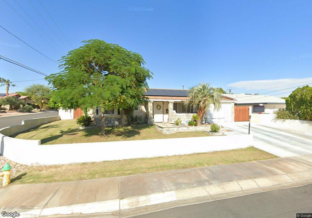
77014 California Dr Palm Desert, CA 92211
Estimated Value: $348,000 - $429,000
2
Beds
2
Baths
1,092
Sq Ft
$361/Sq Ft
Est. Value
About This Home
This home is located at 77014 California Dr, Palm Desert, CA 92211 and is currently estimated at $393,754, approximately $360 per square foot. 77014 California Dr is a home located in Riverside County with nearby schools including Gerald R. Ford Elementary School, Colonel Mitchell Paige Middle School, and Palm Desert High School.
Ownership History
Date
Name
Owned For
Owner Type
Purchase Details
Closed on
Sep 2, 2004
Sold by
Buddhisongranta Phol and Boonma Ratana
Bought by
Stock Steven D and Stock Ruth
Current Estimated Value
Home Financials for this Owner
Home Financials are based on the most recent Mortgage that was taken out on this home.
Original Mortgage
$212,000
Outstanding Balance
$110,174
Interest Rate
6.62%
Mortgage Type
Purchase Money Mortgage
Estimated Equity
$283,580
Purchase Details
Closed on
Apr 29, 2004
Sold by
Jones James Keith
Bought by
Buddhisongranta Phol and Boonma Ratana
Home Financials for this Owner
Home Financials are based on the most recent Mortgage that was taken out on this home.
Original Mortgage
$189,600
Interest Rate
5.92%
Mortgage Type
Purchase Money Mortgage
Create a Home Valuation Report for This Property
The Home Valuation Report is an in-depth analysis detailing your home's value as well as a comparison with similar homes in the area
Home Values in the Area
Average Home Value in this Area
Purchase History
| Date | Buyer | Sale Price | Title Company |
|---|---|---|---|
| Stock Steven D | $265,000 | First American Title Co | |
| Buddhisongranta Phol | $237,000 | First American Title Co |
Source: Public Records
Mortgage History
| Date | Status | Borrower | Loan Amount |
|---|---|---|---|
| Open | Stock Steven D | $212,000 | |
| Previous Owner | Buddhisongranta Phol | $189,600 |
Source: Public Records
Tax History Compared to Growth
Tax History
| Year | Tax Paid | Tax Assessment Tax Assessment Total Assessment is a certain percentage of the fair market value that is determined by local assessors to be the total taxable value of land and additions on the property. | Land | Improvement |
|---|---|---|---|---|
| 2025 | $5,283 | $369,359 | $110,803 | $258,556 |
| 2023 | $5,283 | $355,018 | $106,501 | $248,517 |
| 2022 | $4,957 | $348,058 | $104,413 | $243,645 |
| 2021 | $4,754 | $333,760 | $84,000 | $249,760 |
| 2020 | $4,282 | $298,000 | $75,000 | $223,000 |
| 2019 | $3,626 | $244,400 | $72,800 | $171,600 |
| 2018 | $3,505 | $235,000 | $70,000 | $165,000 |
| 2017 | $3,490 | $235,000 | $70,000 | $165,000 |
| 2016 | $3,371 | $227,000 | $68,000 | $159,000 |
| 2015 | $2,946 | $190,000 | $57,000 | $133,000 |
| 2014 | $2,743 | $190,000 | $57,000 | $133,000 |
Source: Public Records
Map
Nearby Homes
- 77034 California Dr
- 76937 California Dr
- 76954 Florida Ave
- 76826 California Dr
- 77140 Florida Ave
- 77125 Indiana Ave
- 76718 Kentucky Ave
- 76726 Kentucky Ave
- 43660 Elkhorn Trail
- 76835 Oklahoma Ave
- 76701 California Dr
- 77405 Colorado St
- 77340 Florida Ave
- 42795 Tennessee Ave
- 43305 Illinois Ave
- 43725 Texas Ave
- 77431 Huntley Dr
- 42725 Turqueries Ave
- 42706 Liolios Dr
- 43791 Calle Las Brisas W
- 77018 California Dr
- 77031 Indiana Ave
- 77041 Indiana Ave
- 77022 California Dr
- 77010 California Dr
- 77011 California Dr
- 77045 Indiana Ave
- 43671 Tennessee Ave
- 77015 California Dr
- 77026 California Dr
- 76998 California Dr
- 77017 California Dr
- 43655 Tennessee Ave
- 77009 California Dr
- 77055 Indiana Ave
- 77021 California Dr
- 76986 California Dr
- 43631 Tennessee Ave
- 77007 California Dr
- 77030 Indiana Ave