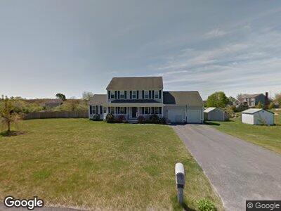
771 Council Oak Way Dighton, MA 02715
Estimated Value: $577,000 - $721,000
3
Beds
3
Baths
2,020
Sq Ft
$327/Sq Ft
Est. Value
About This Home
This home is located at 771 Council Oak Way, Dighton, MA 02715 and is currently estimated at $659,948, approximately $326 per square foot. 771 Council Oak Way is a home located in Bristol County with nearby schools including Dighton-Rehoboth Regional High School.
Ownership History
Date
Name
Owned For
Owner Type
Purchase Details
Closed on
Jun 30, 2003
Sold by
Long Realty Inc
Bought by
Shea David F and Shea Hollyann
Current Estimated Value
Home Financials for this Owner
Home Financials are based on the most recent Mortgage that was taken out on this home.
Original Mortgage
$240,000
Interest Rate
5.53%
Mortgage Type
Purchase Money Mortgage
Create a Home Valuation Report for This Property
The Home Valuation Report is an in-depth analysis detailing your home's value as well as a comparison with similar homes in the area
Home Values in the Area
Average Home Value in this Area
Purchase History
| Date | Buyer | Sale Price | Title Company |
|---|---|---|---|
| Shea David F | $382,284 | -- |
Source: Public Records
Mortgage History
| Date | Status | Borrower | Loan Amount |
|---|---|---|---|
| Open | Shea David F | $90,000 | |
| Open | Shea David F | $319,000 | |
| Closed | Shea David F | $60,000 | |
| Closed | Shea David F | $240,000 |
Source: Public Records
Tax History Compared to Growth
Tax History
| Year | Tax Paid | Tax Assessment Tax Assessment Total Assessment is a certain percentage of the fair market value that is determined by local assessors to be the total taxable value of land and additions on the property. | Land | Improvement |
|---|---|---|---|---|
| 2025 | $7,012 | $558,300 | $138,700 | $419,600 |
| 2024 | $6,819 | $498,500 | $132,200 | $366,300 |
| 2023 | $6,347 | $455,300 | $132,200 | $323,100 |
| 2022 | $6,102 | $427,000 | $130,900 | $296,100 |
| 2021 | $5,966 | $402,300 | $130,900 | $271,400 |
| 2020 | $6,137 | $409,700 | $155,800 | $253,900 |
| 2019 | $6,069 | $404,900 | $155,800 | $249,100 |
| 2018 | $5,744 | $386,300 | $139,600 | $246,700 |
| 2017 | $5,266 | $352,500 | $151,600 | $200,900 |
| 2016 | $5,238 | $343,900 | $156,300 | $187,600 |
| 2015 | $5,171 | $349,400 | $164,400 | $185,000 |
| 2014 | $5,236 | $343,800 | $169,900 | $173,900 |
Source: Public Records
Map
Nearby Homes
- 1971 Elm St
- 37 Waterford Cir
- 352 Main St
- R84 Boxwood Ln Unit 84
- 1337 Karen Rd
- 418 Hart St
- 1325 Rebecca Rd
- 2206 Williams St
- 2375 Williams St
- 2440 County St
- 2120 Water St
- 7 Maris Ln
- 1067 Middle St
- 79 Clubhouse Dr Unit 79
- 3070 Clubhouse Dr Unit Lot 121
- 3082 Hunter Hill Dr Unit Lot 108
- 926 Somerset Ave
- 3057 Anderson Dr
- 3035 Anderson Dr
- 3035 Anderson Dr Unit 8
- 771 Council Oak Way
- 761 Council Oak Way
- 2021 Milk St
- 2060 Manomet Ave
- 2041 Milk St
- 1970 Massasoit Rd
- 2040 Manomet Ave
- 1975 Milk St
- 2061 Milk St
- 758 Council Oak Way
- 751 Council Oak Way
- 1980 Milk St
- 2080 Manomet Ave
- 1953 Massasoit Rd
- 2004 Milk St
- 2004 Milk St Unit 1
- 1940 Massasoit Rd
- 1960 Milk St
- 1945 Milk St
- 2061 Manomet Ave