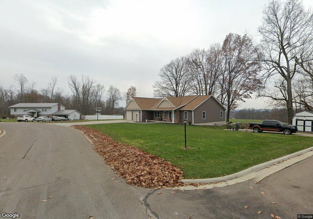
771 Walnut Dr Mansfield, OH 44904
Estimated Value: $291,000 - $534,512
3
Beds
3
Baths
2,259
Sq Ft
$179/Sq Ft
Est. Value
About This Home
This home is located at 771 Walnut Dr, Mansfield, OH 44904 and is currently estimated at $403,378, approximately $178 per square foot. 771 Walnut Dr is a home located in Richland County with nearby schools including Lexington High School, Mansfield Christian School, and Grace Christian School.
Ownership History
Date
Name
Owned For
Owner Type
Purchase Details
Closed on
Jun 27, 2024
Sold by
Campbell Allison R
Bought by
Donley Nathan J
Current Estimated Value
Purchase Details
Closed on
Jul 19, 2005
Sold by
Bonte Richard S and Bonte Mary Jo
Bought by
Donley Nathan J and Donley Linda F
Home Financials for this Owner
Home Financials are based on the most recent Mortgage that was taken out on this home.
Original Mortgage
$154,749
Interest Rate
5.68%
Mortgage Type
FHA
Create a Home Valuation Report for This Property
The Home Valuation Report is an in-depth analysis detailing your home's value as well as a comparison with similar homes in the area
Home Values in the Area
Average Home Value in this Area
Purchase History
| Date | Buyer | Sale Price | Title Company |
|---|---|---|---|
| Donley Nathan J | -- | None Listed On Document | |
| Donley Nathan J | $156,000 | Chicago Title |
Source: Public Records
Mortgage History
| Date | Status | Borrower | Loan Amount |
|---|---|---|---|
| Previous Owner | Donley Nathan J | $154,749 |
Source: Public Records
Tax History
| Year | Tax Paid | Tax Assessment Tax Assessment Total Assessment is a certain percentage of the fair market value that is determined by local assessors to be the total taxable value of land and additions on the property. | Land | Improvement |
|---|---|---|---|---|
| 2024 | $8,171 | $159,440 | $12,750 | $146,690 |
| 2023 | $8,354 | $159,440 | $12,750 | $146,690 |
| 2022 | $7,627 | $120,230 | $10,990 | $109,240 |
| 2021 | $7,736 | $120,230 | $10,990 | $109,240 |
| 2020 | $7,344 | $120,230 | $10,990 | $109,240 |
| 2019 | $6,511 | $97,860 | $8,950 | $88,910 |
| 2018 | $2,560 | $8,950 | $8,950 | $0 |
| 2017 | $2,505 | $45,710 | $8,950 | $36,760 |
| 2016 | $2,477 | $43,650 | $8,270 | $35,380 |
| 2015 | $2,477 | $43,650 | $8,270 | $35,380 |
| 2014 | $2,388 | $43,650 | $8,270 | $35,380 |
| 2012 | $1,162 | $44,990 | $8,520 | $36,470 |
Source: Public Records
Map
Nearby Homes
- 2226 Camden Ct
- 515 W Hanley Rd
- 633 Princeton Ct
- 1332 Bella Vista Ave
- 1346 Bella Vista Ave
- 752 Vanderbilt Rd
- 1938 Richwood Dr
- 309 Vanderbilt Rd
- 615 Bailey Dr
- 0
- 763 York St W
- 635 Karlson Dr
- 1759 Rocky Rill Ct
- 0 Rippling Brook Dr
- 1702 Middle Bellville Rd
- 872 Red Oak Trail Unit 3
- 0 Lot #23132 Hess Cir
- 0 Lot #23127 Hess Cir
- 0 Lot #23139 Hess Cir
- 0 Lot #23121 Hess Cir
- 771 Walnut Dr
- 775 Walnut Dr
- 780 Walnut Dr N
- 775 Walnut Dr
- 770 Walnut Dr
- 781 Walnut Dr N
- 765 Walnut Dr
- 778 Walnut Dr N
- 750 Walnut Dr
- 779 Walnut Dr N
- 755 Walnut Dr
- 751 Vicksburg Dr
- 776 Walnut Dr N
- 740 Walnut Dr S
- 740 Walnut Dr
- 774 Walnut Dr N
- 745 Walnut Dr
- 739 Vicksburg Dr
- 745 Walnut Dr S
- 627 Walnut Dr N
Your Personal Tour Guide
Ask me questions while you tour the home.